geo.wikisort.org - Mountains
The Sierra Madre del Sur is a mountain range in southern Mexico, extending 1,000 kilometres (620 mi) from southern Michoacán east through Guerrero, to the Isthmus of Tehuantepec in eastern Oaxaca.
This article needs additional citations for verification. (December 2011) |
| Sierra Madre del Sur | |
|---|---|
 Sierra Madre del Sur on the coast west of Playa Azul, in Michoacán. | |
| Highest point | |
| Elevation | 3,720 m (12,200 ft) |
| Coordinates | 17°55′41″N 100°18′0″W |
| Dimensions | |
| Length | 1,000 km (620 mi) NW x SE[1] |
| Area | 143,447 km2 (55,385 sq mi) |
| Geography | |
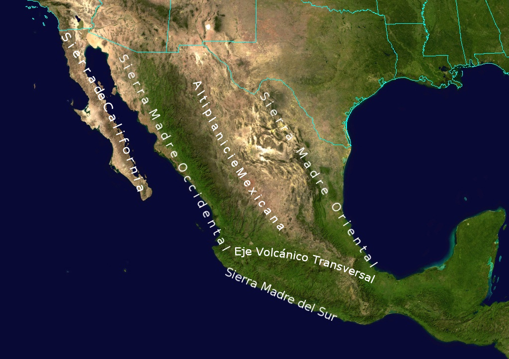 Sierra Madre del Sur, other major mountain ranges, and the Mexican Plateau
| |
| Country | Mexico |
| States | Michoacan, Guerrero, Oaxaca |
Geography
The Sierra Madre del Sur joins with the Eje Volcánico Transversal (Trans-Mexican Volcanic Belt) of central Mexico in northern Oaxaca, but is separated from this range further west by the valley of the Balsas River and its tributary the Tepalcatepec River.
The mountains' highest point is Cerro Nube – 3,720 metres (12,200 ft), in southern Oaxaca, and just one major highway crosses the range between Acapulco and Mexico City.[2]
Although separated from the main part of the Sierra Madre del Sur by the deep canyon of the lower Río Balsas, the mountains of southern Michoacán around Coalcomán are usually considered part of the Sierra Madre del Sur.
Ecology
The range is noted for its very high biodiversity and large number of endemic species.
The Sierra Madre del Sur pine-oak forests ecoregion occupies the higher reaches of the range. These forests are part of a chain of Mesoamerican pine-oak forests that stretch from the Southwestern United States to Costa Rica along the American Cordillera.
Lower elevations of the range are covered by tropical dry forests. Tropical dry forests include closed-canopy forests, woodlands, and thorn scrub, and many trees and shrubs lose their leaves during the winter dry season. The Jalisco dry forests ecoregion occupies the western end of the range's Pacific slope. The Southern Pacific dry forests occupy most of the Pacific slope of the range, from Michoacan in the west through Guerrero and Oaxaca. The basin of the Balsas River, north of the Sierra, is home to the Balsas dry forests.

Protected areas
Protected areas in the Sierra include the Sierra de Manantlán, Zicuirán-Infiernillo, and Tehuacán-Cuicatlán biosphere reserves, General Juan Álvarez National Park, Boquerón de Tonalá Flora and Fauna Protection Area, Omiltemi Ecological State Park, Los Olivos and El Nanchal state reserves, and the Campo Verde, Iliatenco, Cafetal San Juanito (Pluma Hidalgo), Cafetal Soconusco, Cerro Azul, Concepción Vista Hermosa, El Corozal, and El Borbollón, La Pandura y La Yerbabuena voluntary conservation areas.[3]
References
- "Sierra Madre del Sur". Peakbagger.com. Retrieved 17 March 2013.
- Lee Stacy (October 2002). Mexico and the United States. Marshall Cavendish. p. 754. ISBN 978-0-7614-7402-9.
- "Sierra Madre del Sur pine-oak forests". DOPA Explorer. Accessed 15 September 2021.
External links
Sierra Madre del Sur
- "Sierra Madre del Sur pine-oak forests". Terrestrial Ecoregions. World Wildlife Fund.
- World Wildlife Fund, ed. (2001). "Sierra Madre del Sur pine-oak forests". WildWorld Ecoregion Profile. National Geographic Society. Archived from the original on 2010-03-08.
Chilpancingo (capital) | |
| Municipalities and (municipal seats) |
|
| Protected areas |
|
Morelia (capital) | ||
| Municipalities and (municipal seats) |
|  |
| Protected areas |
| |
Physical geography | ||
|---|---|---|
|  | |
| ||
Authority control | |
|---|---|
| General |
|
| National libraries | |
На других языках
[de] Sierra Madre del Sur
Die Sierra Madre del Sur ist ein Gebirgszug im Süden Mexikos, der sich über 1000 km vom Süden Michoacáns, östlich durch Guerrero bis zum Isthmus von Tehuantepec im Osten von Oaxaca erstreckt.- [en] Sierra Madre del Sur
[fr] Sierra Madre del Sur
La sierra Madre del Sur (« Sierra Madre du Sud ») est une chaîne de montagnes localisée dans le Sud du Mexique. Elle s'étend sur une longueur de 1 000 kilomètres entre le sud de Michoacán et l'est d'Oaxaca. Elle est parallèle à la côte de l'océan Pacifique et à l'axe volcanique transversal, dont elle est séparée par la dépression de la Balsas. La cordillère Néovolcanique et la sierra Madre du Sud se rejoignent au nord d'Oaxaca, dans la sierra Mixteca. Son plus haut point, le Cerro Nube, dans l'État d'Oaxaca, est à une altitude de 3 720 mètres. Dans l'État du Guerrero, il faut signaler le Cerro Teotepec, point culminant de cet État à une altitude de 3 540 mètres. Bien qu'elles soient séparées de la chaîne par le canyon de la rivière Balsas, les montagnes situées au sud de Michoacán (connues sous le nom de sierra de Coalcomán), sont aussi considérées comme faisant partie de cette sierra. La cordillère est remarquable par sa grande biodiversité et le grand nombre des espèces endémiques.[it] Sierra Madre del Sud
La Sierra Madre del Sud è una catena montuosa situata nel sud del Messico che si estende per oltre 1.200 km tra il Messico meridionale e l'Istmo di Tehuantepec nello Stato di Oaxaca. Corre parallela alla costa dell'oceano Pacifico e la Fascia Vulcanica Trasversale, dalla quale è separata dalla depressione del Balsas.[ru] Южная Сьерра-Мадре
Ю́жная Сье́рра-Ма́дре[1][2] (исп. Sierra Madre del Sur) — древняя горная система на юге Мексики, вытянутая на 1000 км вдоль берега Тихого океана — проходит от южной части штата Мичоакан через штат Герреро к перешейку Теуантепек на востоке штата Оахака.Другой контент может иметь иную лицензию. Перед использованием материалов сайта WikiSort.org внимательно изучите правила лицензирования конкретных элементов наполнения сайта.
WikiSort.org - проект по пересортировке и дополнению контента Википедии