geo.wikisort.org - River
The Río de la Plata (Spanish pronunciation: [ˈri.o ðe la ˈplata] (![]() listen), lit. "river of silver"), called River Plate or Platine River in British English and the Commonwealth and La Plata River (occasionally Plata River) in other English-speaking countries, is the estuary formed by the confluence of the Uruguay River and the Paraná River at Punta Gorda. It empties into the Atlantic Ocean and forms a funnel-shaped indentation on the southeastern coastline of South America. Depending on the geographer, the Río de la Plata may be considered a river, an estuary, a gulf, or a marginal sea.[3][better source needed] If considered a river, it is the widest in the world, with a maximum width of 220 kilometres (140 mi).
listen), lit. "river of silver"), called River Plate or Platine River in British English and the Commonwealth and La Plata River (occasionally Plata River) in other English-speaking countries, is the estuary formed by the confluence of the Uruguay River and the Paraná River at Punta Gorda. It empties into the Atlantic Ocean and forms a funnel-shaped indentation on the southeastern coastline of South America. Depending on the geographer, the Río de la Plata may be considered a river, an estuary, a gulf, or a marginal sea.[3][better source needed] If considered a river, it is the widest in the world, with a maximum width of 220 kilometres (140 mi).

| Río de la Plata River Plate, La Plata River, Platine River | |
|---|---|
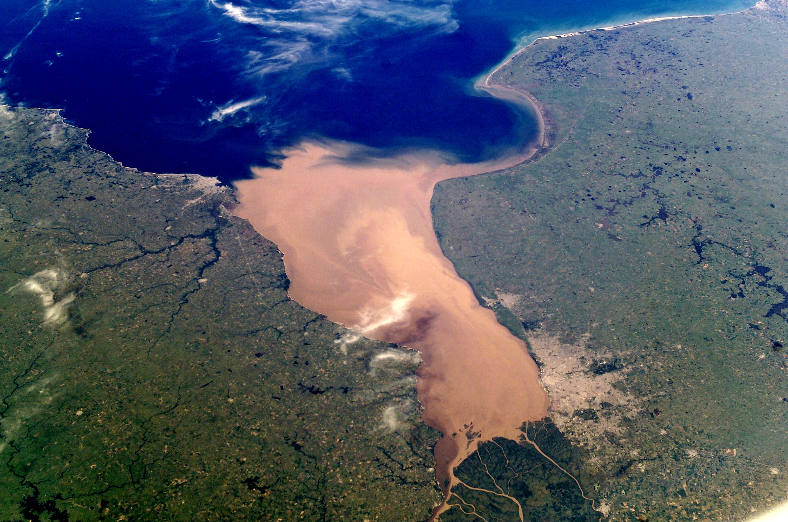 NASA photo of the Río de la Plata looking from northwest to southeast. Buenos Aires is visible on the right side near the Paraná River delta. River sediments turn the seawater brown in the vicinity of Montevideo, visible on the left coast. | |
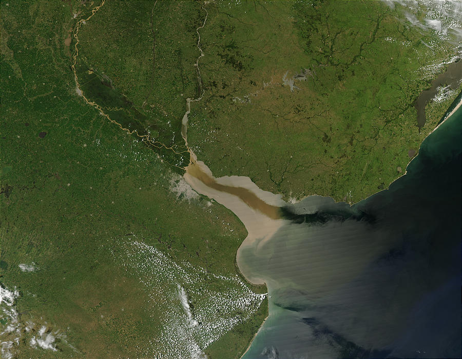
 Map of the Río de la Plata basin, showing the Río de la Plata at the mouths of the Paraná and Uruguay rivers, near Buenos Aires | |
| Etymology | Spanish for "river of silver" |
| Location | |
| Countries | Argentina and Uruguay |
| Cities |
|
| Physical characteristics | |
| Source | Confluence of Paraná and Uruguay Rivers |
| • location | Argentina/Uruguay |
| • coordinates | 34°0′5″S 58°23′37″W[1] |
| Mouth | Atlantic Ocean |
• location | Argentine Sea, Argentina |
• coordinates | 35°40′S 55°47′W[2] |
| Length | 290 km (180 mi)[3] 4,876 km (3,030 mi) including the Paraná |
| Basin size | 3,170,000 km2 (1,220,000 sq mi)[4] 3,182,064 km2 (1,228,602 sq mi)[5] |
| Discharge | |
| • location | Rio de La Plata, Atlantic Ocean |
| • average | (Period 1971-2010)
27,225 m3/s (961,400 cu ft/s)[5] 22,000 m3/s (780,000 cu ft/s)[3] 884 km3/a (28,000 m3/s)[6] |
| • minimum | 12,000 m3/s (420,000 cu ft/s) |
| • maximum | 50,000 m3/s (1,800,000 cu ft/s) |
| Basin features | |
| Tributaries | |
| • left | Uruguay River, San Juan River, Santa Lucía River |
| • right | Paraná River, Luján River, Salado River |
The river is about 290 kilometres (180 mi) long and widens from about 2 kilometres (1.2 mi) at its source to about 220 kilometres (140 mi) at its mouth.[7] It forms part of the border between Argentina and Uruguay. The name Río de la Plata is also used to refer to the populations along the estuary, especially the main port cities of Buenos Aires and Montevideo, where Ríoplatense Spanish is spoken and tango culture developed. The coasts of the river are the most densely-populated areas of Uruguay and Argentina.[3]
Geography
The Río de la Plata begins at the confluence of the Uruguay and Paraná rivers at Punta Gorda and flows eastward into the South Atlantic Ocean. No clear physical boundary marks the river's eastern end; the International Hydrographic Organization defines the eastern boundary of the Río de la Plata as "a line joining Punta del Este, Uruguay and Cabo San Antonio, Argentina".[2]
Though it is generally spoken of as a river, the Río de la Plata is considered by some geographers to be a large bay or marginal sea of the Atlantic Ocean.[3][7] For those who regard it as a river, it is the widest in the world, with a maximum width of about 220 kilometres (140 mi) and a total surface area of about 35,000 square kilometres (14,000 sq mi).[3]
Islands and shoals
The upper river contains several islands, including Oyarvide Island and the Solís Islands in Argentine waters and Juncal Island, Islote el Matón, Martín García Island and Timoteo Domínguez Island in Uruguayan waters. Because of deposition of sediments from the heavy stream load carried down from the river's tributaries, the islands in the Río de la Plata generally grow over time.
A submerged shoal, the Barra del Indio, divides the Río de la Plata into an inner freshwater riverine portion and an outer brackish estuarine portion.[8] The shoal is located approximately between Montevideo and Punta Piedras (the northwest end of Samborombón Bay). The inner fluvial zone is about 180 kilometres (110 mi) long and up to 80 kilometres (50 mi) wide, with a depth which varies from about 1 to 5 metres (3.3 to 16.4 ft); the depth of the outer estuary zone increases from 5 to 25 metres (16 to 82 ft).[8] The river's discharge is strong enough to prevent saltwater from penetrating to the inner portion.[9]
Hydrology
The Río de la Plata behaves as an estuary in which freshwater and seawater mix. The freshwater comes principally from the Paraná River (one of the world's longest rivers and La Plata's main tributary) as well as from the Uruguay River and other smaller streams. Currents in the Río de la Plata are dominated by tides reaching to its sources and beyond, into the Uruguay and Paraná rivers.[7] Both rivers are tidally influenced for about 190 kilometres (120 mi).[3] The tidal ranges in the Río de la Plata are small, but its great width allows for a tidal prism important enough to dominate the flow regime despite the huge discharge received from the tributary rivers.
The river is a salt wedge estuary in which saltwater, being more dense than freshwater, penetrates into the estuary in a layer below the freshwater, which floats on the surface. Salinity fronts, or haloclines, form at the bottom and on the surface, where fresh and brackish waters meet. The salinity fronts are also pycnoclines due to the water density discontinuities. They play an important role in the reproductive processes of fish species.[8]
Drainage basin
The Río de la Plata's drainage basin (sometimes called the Platine basin or Platine region)[10][11] is the 3,170,000 km2 (1,220,000 sq mi)[3]-3,182,064 km2 (1,228,602 sq mi) hydrographical area that drains to the Río de la Plata. It includes areas of southeastern Bolivia, southern and central Brazil, the entire country of Paraguay, most of Uruguay, and northern Argentina. Making up about one fourth of the continent's surface, it is the second largest drainage basin in South America (after the Amazon basin) and one of the largest in the world.[4]
Tributaries
The main rivers of the La Plata basin are the Paraná River, the Paraguay River (the Paraná's main tributary), and the Uruguay River.[8]
The Paraná River's main tributaries include the Paranaíba River, Grande River, Tietê River, Paranapanema River, Iguazu River, Paraguay River, and the Salado River, after which it ends in the large Paraná Delta. The Paraguay River flows through the Pantanal wetland, after which its main tributaries include the Pilcomayo River and the Bermejo River, before it ends in the Paraná. The Uruguay's main tributaries include the Pelotas River, Canoas River, Ibicuí River, and the Río Negro. Another significant tributary to the Río de la Plata is the Salado del Sur River.
History

European exploration
The Río de la Plata was first explored by the Portuguese in 1512–13.[12][13] The Spanish first explored it in 1516, when the navigator Juan Díaz de Solís traversed it during his search for a passage between the Atlantic and the Pacific Oceans, calling it the Mar Dulce, or "freshwater sea."[3] The Portuguese navigator Ferdinand Magellan briefly explored the estuary in 1520 before his expedition continued its circumnavigation,[3] and in 1521 Cristóvão Jacques also explored the Plate River estuary and ascended the Parana River for the first time, entering it for about 23 leagues (around 140 km) to near the present city of Rosario.[14]
Explorer Sebastian Cabot made a detailed study of the river and its tributaries and gave it its modern name. He explored the Paraná and Uruguay rivers between 1526 and 1529, ascending the Paraná as far as the present-day city of Asunción, and also explored up the Paraguay River. Cabot acquired silver trinkets trading with the Guaraní near today's Asunción, and these objects (together with legends of a "Sierra de la Plata" in the South American interior brought back by earlier explorers) inspired him to rename the river "Río de la Plata" ("River of Silver").[3]
The first European colony was the city of Buenos Aires, founded by Pedro de Mendoza on 2 February 1536. This settlement, however, was quickly abandoned; the failure to establish a settlement on the estuary led to explorations upriver and the founding of Asunción in 1537. The area was visited by Francis Drake's fleet in early 1578, in the early stages of his circumnavigation.[15] Buenos Aires was refounded by Juan de Garay on 11 June 1580.[3]
Colonial period

During the colonial era, the Río de la Plata was made the center of the Governorate of the Río de la Plata. The Río de la Plata region, particularly Buenos Aires, was a significant site of trade throughout the 17th century. The Crown initially intended Buenos Aires to be a military establishment for the protection of the Potosí mines, but it soon became evident that a settlement large enough to provide military defense would attract trade. The primary export was silver from the mines of Potosí, and imports generally included European luxury goods, slaves, and sugar. This trade occurred outside of the fleet system authorized by the Spanish Crown, and therefore was generally considered "illicit." However, under the monarchy of the Spanish Habsburgs, the line between licit and illicit trade was quite blurry. Crown officials and military outposts in Buenos Aires often relied upon profits from illicit trade to support their administrative structures.[16]
Under the Bourbon monarchy, the governorate was elevated to the Viceroyalty of the Río de la Plata in 1776. This occurred as a result of the Bourbon Reforms, which attempted to restore the decaying wealth of the Spanish Crown. The reforms elevated the status of trade along the Río de la Plata and expanded what constituted "legal" trade so that the Crown could tax trade what had previously been "contraband." However, the plan did not go as intended. Although trade along the Río de la Plata flourished, very little silver was actually remitted to the Crown. Then, Spanish war with Britain and the simultaneous eruption of revolts in the mining regions of Peru led to a shortage of silver, putting strain on the merchant class of Buenos Aires. This caused a schism between merchants who wanted to try to continue reviving the Spanish Empire through silver trade and those who wanted to move on from silver and prioritize agricultural exports, ultimately tearing at the fabric of the Río de la Plata region's relationship with the Spanish Empire.[17]
In 1806 and 1807 the river was the scene of an important British invasion that aimed to occupy the area and was defeated by the local garrison and population.
Revolutionary period
Conflict in the region intensified after the independence of the former Spanish and Portuguese colonies in the first quarter of the 19th century. Interests in the territories and the navigation rights over the Platine region played a major role in many armed conflicts throughout the century, including the Argentine civil wars, the Cisplatine and Platine wars, and the Paraguayan War.[3] The river was blockaded by France and Britain in 1838–1840 and 1845–1850.
Naval Battles
Battle of Juncal (1827)

During the Cisplatine War, the Battle of Juncal (named after Juncal Island) took place in the waters of the Río de la Plata from 8–9 February 1827 between squadrons of the newly independent United Provinces of the River Plate and the Brazilian Empire. The Argentines scored a decisive victory, capturing or destroying fifteen Brazilian vessels and losing none.[18]
Battle of the River Plate (1939)
In the first naval battle of the Second World War the German pocket battleship Admiral Graf Spee was engaged by the Royal Navy (RN) cruisers HMS Exeter and Ajax, and the Royal New Zealand Navy cruiser Achilles,[19] off the estuary of the River Plate in December 1939. The German ship retired up the estuary with a crippled fuel system and put into port at Montevideo. A few days later, rather than fight when believing himself outgunned, her captain scuttled her in the estuary. This engagement was part of the early Battle of the Atlantic.
English names
The historical English name "River Plate" uses an obsolete sense of the word "plate", which was used extensively as a term for "silver" or "gold" from the 12th century onwards, especially in Early Modern English.[20] The estuary has been known as the River Plate or Plate River in English since at least the time of Francis Drake.[21] This English version of the name served as an inspiration for one of Argentina's most important football clubs, Club Atlético River Plate.
A more literal translation of the name is "Silver River", though this is virtually never used in practice.
Fauna
The Río de la Plata is a habitat for the loggerhead sea turtle, green sea turtle, leatherback sea turtle, the rare La Plata dolphin, and many species of fish.
See also
- Rioplatense Spanish
- Argentina–Uruguay relations
- 1973 Boundary Treaty between Uruguay and Argentina
- The Fontana dei Quattro Fiumi, in Rome's Piazza Navona, contains a figure representing the River Plate.
- 1888 Río de la Plata earthquake
References
- Río Paraná Guazú at GEOnet Names Server (main distributary of the Río Paraná)
- "Limits of Oceans and Seas, 3rd edition" (PDF). International Hydrographic Organization. 1953. Archived from the original (PDF) on 8 October 2011. Retrieved 28 December 2020.
- "Río de la Plata". Encyclopædia Britannica. Archived from the original on 9 May 2015. Retrieved 11 August 2010.
- Raúl A. Guerrero; et al. (June 1997). "Physical oceanography of the Río de la Plata Estuary, Argentina". Continental Shelf Research. 17 (7): 727–742. Bibcode:1997CSR....17..727G. doi:10.1016/S0278-4343(96)00061-1.
- "Balance hídrico en la Cuenca del Plata".
- "Transboundary River Basin Overview – La Plata" (PDF).
- Fossati, Monica; Piedra-Cueva, Ismael. "Salinity Simulations of the Rio de la Plata" (PDF). International Conference on Estuaries and Coasts. Archived from the original (PDF) on 6 March 2012. Retrieved 11 August 2010.
- Seeliger, Ulrich; Kjerfve, Björn (2001). Coastal Marine Ecosystems of Latin America. Springer. pp. 185–204. ISBN 978-3-540-67228-9. Archived from the original on 2017-03-23. Retrieved 2016-02-23.
- Cabreira, A.G.; Madirolas, A.; Alvarez Colombo, G.; Acha, E.M.; Mianzan, H.W. (2006). "Acoustic study of the Río de la Plata estuarine front". ICES Journal of Marine Science. 63 (9): 1718–1725. doi:10.1016/j.icesjms.2006.04.026. ISSN 1095-9289.
- Whigham, Thomas. 2002. The Paraguayan War: Causes and Early Conduct, v. 1. Lincoln, Nebraska: University of Nebraska Press, p. 5. ISBN 978-0-8032-4786-4
- e.g., Scheina, Robert L. 2003. Latin America's Wars: The Age of the Caudillo, 1791–1899, v. 1. Dulles, Virginia: Brassey's, Inc., p. 313. ISBN 978-1-5748-8450-0
- Viana 1994, p. 254.
- Bethell 1987, p. 64.
- John/Silva, Harold/Maria Beatriz Nizza da (1992). Nova História da Expansão Portuguesa (direcção de Joel Serrão e A. H. de Oliveira Marques)- O Império Luso-brasileiro (1500-1620), vol. VI. Lisboa: Editorial Presença. pp. 114–170.
- Kelsey, Harry (2000). Sir Francis Drake: The Queen's Pirate. Yale University Press. pp. 100–102. ISBN 978-0-300-08463-4.
- Moutoukias, Zacarias (1988). "Power, Corruption, and Commerce: The Making of the Local Administrative Structure in Seventeenth-Century Buenos Aires". The Hispanic American Historical Review. 68 (4): 771–801. doi:10.2307/2515681. ISSN 0018-2168. JSTOR 2515681.
- Adelman, Jeremy (2 July 2002). Republic of capital: Buenos Aires and the legal transformation of the Atlantic world. Stanford University Press. ISBN 978-0-8047-6414-8.
- A War Betwixt Englishmen: Brazil Against Argentina on the River Plate 1825-1830, Brian Vale, I. B. Tauris, page 137, chapter 14
- (The Achilles was part of the New Zealand Division)
- Oxford English Dictionary, 2nd edition, online version.
- "Sir Francis Drake's Famous Voyage Round the World; A Narrative by Francis Pretty, one of Drake's Gentlemen at Arms". Archived from the original on 2007-02-04. Retrieved 2007-01-09.
Bibliography
- Mulhall, Michael George, and; Mulhall, Edward T. (1869). "Handbook of the River Plate: Comprising Buenos Ayres, the Upper Provinces, Banda Oriental, Paraguay".
- Bethell, Leslie (1987). Colonial Brazil. Cambridge: Cambridge University Press. ISBN 0-521-34127-2.
- Viana, Hélio (1994). História do Brasil: período colonial, monarquia e república (in Portuguese) (15 ed.). São Paulo: Melhoramentos. ISBN 978-85-06-01999-3.
- Piola, A. R.; Matano, R. P.; Palma, E. D.; Campos, E. D. (2005). "The influence of the Plata River discharge on the western South Atlantic shelf" (PDF). Geophysical Research Letters. 32 (1): L01603. Bibcode:2005GeoRL..32.1603P. doi:10.1029/2004GL021638.
- Real, Walter. España en el Río de la Plata: Descubrimiento y Poblamientos (1516–1588). Montevideo: Club Español. 2001. ISBN 9974-39-317-5.
- Simionato, Claudia G.; Vera, Carolina S.; Siegismund, Frank (2005). "Surface Wind Variability on Seasonal and Interannual Scales Over Río de la Plata Area". Journal of Coastal Research. 21 (4): 770–78. doi:10.2112/008-NIS.1. S2CID 131049528.
External links
- Treaty between Uruguay and Argentina concerning the Rio de la Plata and the Corresponding Maritime Boundary (19 November 1973)
- Paraguay, or the Province of the Rio de la Plata, with the Adjacent Regions Tucamen and Santa Cruz de la Sierra is a map from 1616 depicting the area
- "An Account of a Voyage up the River de la Plata, and Thence over Land to Peru: With Observations on the Inhabitants, as Well as Indians and Spaniards, the Cities, Commerce, Fertility, and Riches of That Part of America" from 1698
- . New International Encyclopedia. 1905.
Authority control | |
|---|---|
| General | |
| National libraries | |
| Other | |
На других языках
[de] Río de la Plata
Als Río de la Plata (spanisch für Silberfluss) wird der gemeinsame 290 km lange und bis zu 220 km breite Mündungstrichter der großen südamerikanischen Ströme Paraná und Uruguay in den Atlantischen Ozean bezeichnet. Das Wasser des Río de la Plata ist durch den hohen Eintrag von lehmigem Schlamm trüb. Aus der Luft kann man sehen, wie sich das ockerfarbene Wasser des Uruguay nur langsam mit dem rotbraunen Wasser des Paraná vermischt. Das Revier weist nur geringe Tiefen auf, im Allgemeinen unter 20 m, so dass Schiffe mit größerem Tiefgang, die Buenos Aires ansteuern, ausgebaggerte Fahrrinnen benutzen müssen.- [en] Río de la Plata
[it] Río de la Plata
Il Río de la Plata (che in spagnolo significa Fiume dell'Argento), talvolta italianizzato in Rio della Plata, è l'estuario formato dal fiume Uruguay e dal fiume Paraná; si tratta di una rientranza a forma di imbuto della costa meridionale del Sud America, lunga 290 chilometri.[ru] Ла-Плата (эстуарий)
Ла-Пла́та (исп. Río de la Plata — «серебряная река») — эстуарий, образованный при слиянии рек Уругвай и Парана. Это залив на юго-восточном побережье Южной Америки, растянувшийся на 320 км от слияния рек до Атлантического океана[1].Другой контент может иметь иную лицензию. Перед использованием материалов сайта WikiSort.org внимательно изучите правила лицензирования конкретных элементов наполнения сайта.
WikiSort.org - проект по пересортировке и дополнению контента Википедии