geo.wikisort.org - Island
Timoteo Domínguez Island (Spanish: Isla Timoteo Domínguez) is an Uruguayan island off the Río de la Plata coast of Uruguay.
This article needs additional citations for verification. (September 2013) |
Isla Timoteo Domínguez | |
|---|---|
 Aerial view of the island formed by (former) islands Timoteo Domínguez (Uruguay) (top right), and Martín García (Argentina) (bottom left), looking west (November 2019) | |
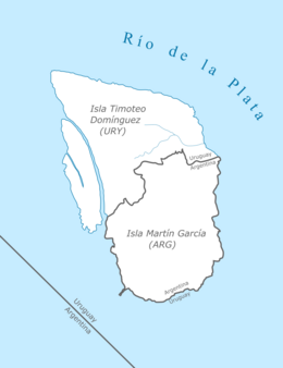 Diagram of Timoteo Domínguez and Martín García Islands | |
| Geography | |
| Location | Río de la Plata |
| Coordinates | 34°10.2′S 58°15.4′W |
| Area | 1.9 km2 (0.73 sq mi) |
| Administration | |
Uruguay | |
| Department | Colonia |
| Demographics | |
| Population | 0 |
The Argentine exclave Martín García island is within the boundaries of Uruguayan waters; in 1973 both countries reached an agreement establishing Martín García as an Argentine territory and also as a nature reserve. In recent decades, river sediments gave birth to the very first dry limit between Argentina and Uruguay: the islands Martín García and Timoteo Domínguez are united.[1]
References
Wikimedia Commons has media related to Isla Timoteo Domínguez.
This article about a location in Uruguay is a stub. You can help Wikipedia by expanding it. |
This article about an island is a stub. You can help Wikipedia by expanding it. |
На других языках
- [en] Timoteo Domínguez Island
[es] Isla Timoteo Domínguez
La Isla Timoteo Domínguez (antiguamente conocida como Punta de Bauzá) es una isla del Río de la Plata bajo soberanía de la República Oriental del Uruguay.Текст в блоке "Читать" взят с сайта "Википедия" и доступен по лицензии Creative Commons Attribution-ShareAlike; в отдельных случаях могут действовать дополнительные условия.
Другой контент может иметь иную лицензию. Перед использованием материалов сайта WikiSort.org внимательно изучите правила лицензирования конкретных элементов наполнения сайта.
Другой контент может иметь иную лицензию. Перед использованием материалов сайта WikiSort.org внимательно изучите правила лицензирования конкретных элементов наполнения сайта.
2019-2026
WikiSort.org - проект по пересортировке и дополнению контента Википедии
WikiSort.org - проект по пересортировке и дополнению контента Википедии