geo.wikisort.org - River
The Paraná River (Spanish: Río Paraná Spanish pronunciation: [ˈri.o paɾaˈna] (![]() listen), Portuguese: Rio Paraná, Guarani: Ysyry Parana) is a river in south Central South America, running through Brazil, Paraguay, and Argentina for some 4,880 kilometres (3,030 mi).[3] It is second in length only to the Amazon River among South American rivers. It merges with the Paraguay River and then farther downstream with the Uruguay River to form the Río de la Plata and empties into the Atlantic Ocean.
listen), Portuguese: Rio Paraná, Guarani: Ysyry Parana) is a river in south Central South America, running through Brazil, Paraguay, and Argentina for some 4,880 kilometres (3,030 mi).[3] It is second in length only to the Amazon River among South American rivers. It merges with the Paraguay River and then farther downstream with the Uruguay River to form the Río de la Plata and empties into the Atlantic Ocean.
| Paraná River Rio Paraná, Río Paraná | |
|---|---|
 Paraná River seen from Zárate, Buenos Aires Province, Argentina | |
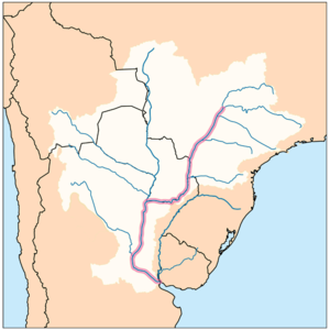 Map of the Rio de la Plata Basin showing the Paraná River in highlight | |
| Native name | Parana (Guarani) |
| Location | |
| Countries |
|
| Region | South America |
| Physical characteristics | |
| Source | Paranaíba River |
| • location | Rio Paranaíba, Minas Gerais, Brazil |
| • coordinates | 19°13′21″S 46°10′28″W[1] |
| • elevation | 1,148 m (3,766 ft) |
| 2nd source | Rio Grande |
| • location | Bocaina de Minas, Minas Gerais, Brazil |
| • coordinates | 22°9′56″S 44°23′38″W |
| Source confluence | Paranaíba and Rio Grande |
| • coordinates | 20°5′12″S 51°0′2″W |
| Mouth | Rio de la Plata |
• location | Atlantic Ocean, Argentina, Uruguay |
• coordinates | 34°0′5″S 58°23′37″W[2] |
• elevation | 0 m (0 ft) |
| Length | 4,880 km (3,030 mi)[3] |
| Basin size | 2,582,672 km2 (997,175 sq mi) |
| Discharge | |
| • location | Paraná Delta, Rio de La Plata |
| • average | (Period 1971-2010)
19,706 m3/s (695,900 cu ft/s)[4] 17,290 m3/s (611,000 cu ft/s)[3] 667 km3/a (21,100 m3/s)[5] |
| • minimum | 2,450 m3/s (87,000 cu ft/s) |
| • maximum | 65,000 m3/s (2,300,000 cu ft/s) |
| Discharge | |
| • location | Corrientes (Basin size 1,950,000 km2 (750,000 sq mi)[4] |
| • average | 18,979 m3/s (670,200 cu ft/s)[4] |
| Discharge | |
| • location | Itaí (Basin size 953,950 km2 (368,320 sq mi) |
| • average | 13,916 m3/s (491,400 cu ft/s)[4] |
| Discharge | |
| • location | Itaipú (Basin size 826,691 km2 (319,187 sq mi) |
| • average | 11,746 m3/s (414,800 cu ft/s)[4] |
| Discharge | |
| • location | Porto Primavera (Basin size 574,379 km2 (221,769 sq mi) |
| • average | 7,938 m3/s (280,300 cu ft/s)[4] |
| Basin features | |
| River system | Río de la Plata |
| Tributaries | |
| • left | Iguaçu, Piquiri, Ivaí, Paranapanema, Tietê, Rio Grande |
| • right | Salado, Paraguay, Ivinhema, Pardo, Paranaiba |
The first European to go up the Paraná River was the Venetian explorer Sebastian Cabot, in 1526, while working for Spain.
In 2021 a drought hit the river causing a 77-year low.[6][7]
Etymology
In eastern South America there is "an immense number of river names containing the element para- or parana-", from Guarani language words meaning "river" or "sea"; attempts to derive a more precise meaning for the name of this, the largest of them, e.g. "kin of the sea", have been discounted.[8]
Course
The course is formed at the confluence of the Paranaiba and Rio Grande rivers in southern Brazil. From the confluence the river flows in a generally southwestern direction for about 619 km (385 mi) before encountering the city of Saltos del Guaira, Paraguay. This was once the location of the Guaíra Falls (Sete Quedas waterfalls, where the Paraná fell over a series of seven cascades. This natural feature was said to rival the world-famous Iguazu Falls to the south. The falls were flooded, however, by the construction of the Itaipu Dam, which began operating in 1984. For approximately the next 200 km (120 mi) the Paraná flows southward and forms a natural boundary between Paraguay and Brazil until the confluence with the Iguazu River. Shortly upstream from this confluence, however, the river is dammed by the Itaipu Dam, the second largest hydroelectric power plant in the world (following the Three Gorges Dam in the People's Republic of China), and creating a massive, shallow reservoir behind it.
After merging with the Iguazu, the Paraná then becomes the natural border between Paraguay and Argentina. Overlooking the Paraná River from Encarnación, Paraguay, across the river, is downtown Posadas, Argentina. The river continues its general southward course for about 468 km (291 mi) before making a gradual turn to the west for another 820 km (510 mi), and then encounters the Paraguay River, the largest tributary along the course of the river. Before this confluence, the river passes through a second major hydroelectric project, the Yaciretá Dam, a joint project between Paraguay and Argentina. The massive reservoir formed by the project has been the source of a number of problems for people living along the river, most notably the poorer merchants and residents in the low-lying areas of Encarnación, a major city on the southern border of Paraguay. River levels rose dramatically upon completion of the dam, flooding out large sections of the city's lower areas.
From the confluence with the Paraguay River, the Paraná again turns to the south for another approximately 820 km (510 mi) through Argentina, making a slow turn back to the east near the city of Rosario for the final stretch of less than 500 km (310 mi) before merging with the Uruguay River to form the Río de la Plata. This flows into the Atlantic Ocean. During the part of its course downstream from the city of Diamante, Entre Ríos, it splits into several arms and it forms the Paraná Delta.
Uses
Together with its tributaries, the Rio Paraná forms a massive drainage basin that encompasses much of the southcentral part of South America, essentially including all of Paraguay, much of southern Brazil, northern Argentina, and the southeastern part of Bolivia. If the Uruguay River is counted as a tributary to the Paraná, this watershed extends to cover most of Uruguay as well. The volume of water flowing into the Atlantic Ocean through the Río de la Plata roughly equals the volume at the Mississippi River delta. This watershed contains a number of large cities, including São Paulo, Buenos Aires, Rosario, Asunción, Brasília, and La Plata.
The Paraná and its tributaries provide a source of income and of daily sustenance for fishermen who live along its banks. Some of the species of fish (such as the surubí and the sábalo) are commercially important, and they are exploited for heavy internal consumption or for export. The Parana River delta ranks as one of the world's greatest bird-watching destinations.[9]
Much of the length of the Paraná is navigable, and the river serves as an important waterway linking inland cities in Argentina and Paraguay with the ocean, providing deepwater ports in some of these cities. The construction of enormous hydroelectric dams along the river's length has blocked its use as a shipping corridor to cities further upstream, but the economic impact of those dams offsets this. The Yacyretá Dam and the Itaipu Dam on the Paraguay border have made the small, largely undeveloped nation of Paraguay the world's largest exporter of hydroelectric power.
Due to its use for oceangoing ships, measurements of the water tables extend back to 1904. The data correlates with the Sun's solar cycle.[10][11]
Gallery
 The sun rising over the Paraná River, from northeast of Rosario, Argentina
 Paraná River source at the border of the states of São Paulo, Mato Grosso do Sul and Minas Gerais, in Brazil.
 Container ship, traveling downstream by the city of Ramallo, Argentina
 The Rosario-Victoria Bridge
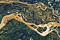 Astronaut's photo showing a 29-kilometre (18 mi) stretch of the Paraná, just downstream from Goya, Argentina
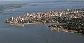 Parana river in Posadas, Argentina
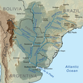 Map of the Rio de la Plata Basin showing the Paraná River and its major tributaries


Links across the Paraná
The course of the Paraná is crossed by the following bridges, beginning upstream:
| Crossing | Location | Built | Carries | Coordinates | |
|---|---|---|---|---|---|
| Brazil | |||||
| Rollemberg–Vuolo Road–Railway Bridge | Aparecida do Taboado-Rubineia | 1998 | 20°06′17.9″S 51°00′32.4″W | ||
| Ilha Solteira Dam | Selvíria-Ilha Solteira | 1973 | 20°22′54.2″S 51°21′59.7″W | ||
| Engineer Souza Dias Dam | Três Lagoas-Castilho | 1968 | BR-262 | 20°46′44.7″S 51°37′49.3″W | |
| Paulicéia-Brasilândia Bridge | Brasilândia-Pauliceia | 2009 | BR-158 | 21°16′08.4″S 51°51′18.8″W | |
| Hélio Serejo (Maurício Joppert) Bridge | Bataguassu-Presidente Epitácio | 1964 | BR-267 | 21°45′12.1″S 52°11′05.6″W | |
| Sérgio Motta (Porto Primavera) Dam | Rosana | 1999 | 22°28′30.5″S 52°57′29.6″W | ||
| Porto Camargo Bridge | Alto Paraíso | BR-487 | 23°22′24.5″S 53°46′08.3″W | ||
| Ayrton Senna Bridge | Mundo Novo-Guaíra | 1998 | BR-163 | 24°03′31″S 54°15′28.6″W | |
| Brazil-Paraguay | |||||
| Friendship Bridge | Ciudad del Este-Foz do Iguaçu | 1965 | PY02-BR-277 | 25°30′33.5″S 54°36′03.3″W | |
| Integration Bridge | Presidente Franco-Foz do Iguaçu | Under construction | 25°35′19″S 54°35′37″W | ||
| Paraguay-Argentina | |||||
| San Roque González de Santa Cruz Bridge | Encarnación-Posadas | 1990 | 27°22′09.3″S 55°51′43.3″W | ||
| Yacyretá Dam | Ayolas-Ituzaingó | 1994 | 27°28′58.5″S 56°44′19.5″W | ||
| Argentina | |||||
| General Manuel Belgrano Bridge | Resistencia-Corrientes | 1973 | National Route 16 | 27°28′12.3″S 58°51′35.1″W | |
| Second Resistencia-Corrientes Bridge | Resistencia-Corrientes | Planned | |||
| Reconquista-Goya Bridge | Reconquista-Goya | Planned | |||
| Raúl Uranga - Carlos Sylvestre Begnis Subfluvial Tunnel | Santa Fe-Paraná | 1969 | National Route 168 | 31°42′08.7″S 60°30′12.6″W | |
| Second Santa Fe-Paraná Bridge | Santa Fe-Paraná | Planned | |||
| Rosario-Victoria Bridge | Rosario-Victoria | 2003 | National Route 174 | 32°52′11.4″S 60°41′07.9″W | |
| Bartolomé Mitre Bridge | Zárate-Ceibas | 1977 | National Route 12 | 34°06′10.9″S 59°00′10″W | |
| Justo José de Urquiza Bridge | Zárate-Ceibas | 1977 | National Route 12 | 33°54′37.1″S 58°53′06.9″W | |
See also
- Tributaries of the Río de la Plata
- Paraná River steamers
References
- "Monitoramento da Qualidade das Águas Superficiais da Bacia do Río Paranaíba: Relatório Annual 2007". Governo do Estado de Minas Gerais, Instituto Mineiro de Gestão das Águas. 2008. Archived from the original (PDF in ZIP) on 6 July 2011. Retrieved 12 August 2010.
- Río Paraná Guazú at GEOnet Names Server (main distributary)
- "Parana River". Encyclopædia Britannica. Encyclopædia Britannica Online. Encyclopædia Britannica Inc., 2012. Web. 26 May. 2012 <https://www.britannica.com/EBchecked/topic/443063/Parana-River Archived 2012-04-28 at the Wayback Machine>. "Rio de la Plata". Encyclopædia Britannica. Encyclopædia Britannica Online. Encyclopædia Britannica Inc., 2012. Web. 26 May. 2012 <https://www.britannica.com/EBchecked/topic/463804/Rio-de-la-Plata Archived 2015-05-09 at the Wayback Machine>
- "Balance hídrico en la Cuenca del Plata".
- "Transboundary River Basin Overview – La Plata" (PDF).
- "South America's drought-hit Paraná river at 77-year low". BBC News. 2021-09-01. Retrieved 2021-09-04.
- "Down river". Reuters. Retrieved 2021-11-06.
- Holmer, Nils m. (1960). "Indian Place Names in South America and the Antilles. I." Names: A Journal of Onomastics. 8 (3): 133–148. doi:10.1179/nam.1960.8.3.133. Retrieved 20 September 2021., pp=139-141.
- Iriondo, Martín H., Juan César Paggi, and María Julieta Parma, eds. The Middle Paraná River: Limnology of a subtropical wetland. Chapter "Birds." Springer Science & Business Media, 2007.
- Pablo J.D. Mauas & Andrea P. Buccino. "Long-term solar activity influences on South American rivers" page 5. Journal of Atmospheric and Solar-Terrestrial Physics on Space Climate, March 2010. Accessed: 20 September 2014.
- Antico, A.; Kröhling, D. M. (October 2011). "Solar motion and discharge of Paraná River, South America: Evidence for a link". Geophysical Research Letters. 38 (19): n/a. Bibcode:2011GeoRL..3819401A. doi:10.1029/2011GL048851. hdl:11336/72975. S2CID 130181708.
External links
- Information and a map of the Paraná's watershed
- . New International Encyclopedia. 1905.
Authority control | |
|---|---|
| General |
|
| National libraries | |
На других языках
[de] Río Paraná
Der Paraná (Guaraní Parana; spanisch Río Paraná; portugiesisch Rio Paraná) ist ein Fluss in Südamerika. Er beginnt am Zusammenfluss des Paranaíba und des Rio Grande an dem Punkt, an dem auch die brasilianischen Bundesstaaten Minas Gerais, São Paulo und Mato Grosso do Sul ein Dreiländereck bilden. Nach etwa 3200 Kilometern in Richtung Süden fließt er mit dem Río Uruguay zusammen zu dem 290 km langen und bis zu 220 km breiten Mündungstrichter des Río de la Plata.- [en] Paraná River
[it] Paraná (fiume)
Il Paraná (in spagnolo: Río Paraná, in portoghese: Rio Paraná) è un fiume del Sud America che attraversa il Brasile, il Paraguay e l'Argentina. È lungo 4.880 chilometri ed è considerato il secondo fiume più lungo del Sud America dopo il Rio delle Amazzoni.[ru] Парана
Парана́ (исп. Paraná, порт. Paraná) — река в Южной Америке, вторая по длине река этого континента (после Амазонки). Протекает в южной части континента по территории Бразилии, Парагвая и Аргентины. Длина собственно Параны (от места слияния Паранаибы и Риу-Гранде) составляет 2570 км, от истока Паранаибы — 3740 км[2]. Площадь бассейна 2 582 672[3] км². Впадает в залив Ла-Плата Атлантического океана недалеко от города Буэнос-Айреса. До города Росарио в нижнем течении осуществляется морское судоходство. В среднем течении по реке проходит государственная граница между Парагваем и Аргентиной, ниже она является западной границей низменного района аргентинского Междуречья.Другой контент может иметь иную лицензию. Перед использованием материалов сайта WikiSort.org внимательно изучите правила лицензирования конкретных элементов наполнения сайта.
WikiSort.org - проект по пересортировке и дополнению контента Википедии