geo.wikisort.org - River
Pilcomayo (in Hispanicized spelling)[2] (Quechua Pillkumayu or Pillku Mayu, pillku red, mayu river,[3] "red river", Guarani Ysyry Araguay [ʔɨsɨˈɾɨ ʔaɾaɰʷaˈɨ]) is a river in central South America. At 1,100 kilometres (680 mi) long,[4] it is the longest western tributary of the Paraguay River. Its drainage basin is 270,000 square kilometres (100,000 sq mi) in area, and its mean discharge is 200 cubic metres per second (7,100 cu ft/s).[4]
| Pilcomayo Ysyry Araguay | |
|---|---|
 Pilcomayo River, seen in Bolivia | |
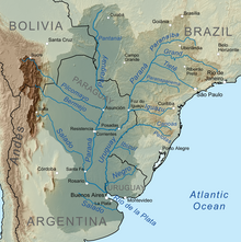 Map of the Rio de la Plata Basin, showing the Pilcomayo joining the Paraguay River near Asunción | |
| Etymology | Quechua |
| Native name | Pillkumayu (Quechua) |
| Location | |
| Countries |
|
| Physical characteristics | |
| Source | Most distant source of Pilcomayo-Pilaya-Camblaya-San Juan-Orosmayo-Ajedrez-Porvenir System |
| • location | East slopes of Cerro Sipisami, Jujui Province, Argentina |
| • coordinates | approximately 22°51′52″S 66°32′55″W |
| • elevation | approximately 4800 m |
| 2nd source | Most distant source of main stem Pilcomayo |
| • location | Municipio Santiago de Huari, Oruro, Bolivia |
| • coordinates | 19°23′36″S 66°25′5″W |
| • elevation | 4820 metres |
| Mouth | Confluence with Paraguay River |
• location | Near Asunción, Paraguay |
• coordinates | 25°16′40″S 57°40′16″W |
Ramsar Wetland | |
| Official name | Rio Pilcomayo |
| Designated | 4 May 1992 |
| Reference no. | 557[1] |
Along its course, the Pilcomayo silts up and splits into two main branches, North and South. After some distance, these branches rejoin to form the Lower Pilcomayo.[4]
The Pilcomayo rises in the foothills of the Andes mountain range in the Oruro Department in Bolivia, east of Lake Poopó. The Jach'a Juqhu River is considered the origin of the Pilcomayo.[5] Upstream the Jach'a Juqhu River successively receives the names Aguas Calientes and Kachi Mayu. From the confluence with the Chillawa (Chillahua), the river is called Pilcomayo.[6][7] From there, it flows in a southeasterly direction through Chuquisaca and Tarija departments, passes through the Argentine province of Formosa and the Gran Chaco plains of Paraguay, forming most of the border between these two countries before it joins the Paraguay River near Asunción. The Río Pilcomayo National Park is located on the Argentine side of the border. It also forms a short part of the boundary between Argentina and Bolivia, just prior to the Argentina–Bolivia–Paraguay tripoint.
Human settlement
The river basin is home to approximately 1.5 million people: one million in Bolivia, 300,000 in Argentina, and 200,000 in Paraguay.
The Nakotoi Indian Tribe resides in the southern region of the Pilcomayo, a region located along the river in central Paraguay.[8] The aborigines of this tribe are descendants of the highly renowned Redskin Tribe.[8] The Natokoi treated all neighbors as enemies, but none more so than the Tobas Tribe and the Nimká Tribe, their respective neighbors to the southwest and northeast.[8] Guerrilla warfare has long existed between the tribes, isolating the tribe from direct intercourse with the European settlers in the late 19th century.[8] Men of this tribe are generally tall and skinny, built like hunters or warriors, whereas women are short in size.[9] The Natokoi dress in a rug, fastened around the waist-line.[9]
Gallery
 Local fishermen with fishing nets crossing Rio Pilcomayo 1908.
 Pilcomayo River as seen through Tarija Department, Bolivia.
 Pilcomayo River highlighted within the Paraná River drainage basin.
 San Ignacio Bridge over Pilcomayo River, between Clorinda and José Falcon (AR)-(PY) border.
 A 19th century-built footbridge over the Pilcomayo River as seen at Bolivia's Route 5, between Sucre and Potosí, Southern Bolivia.
 Pilcomayo Valley, near Villamontes, Bolivia.
 Pilcomayo River, near Asunción.


See also
- List of rivers of Argentina
- List of rivers of Paraguay
- List of rivers of Bolivia
- Oroncota, Yampara settlement and Inca fortress in the Pilcomayo River valley of Bolivia.
- Gran Chaco
References
- "Rio Pilcomayo". Ramsar Sites Information Service. Retrieved 25 April 2018.
- Río Pilcomayo at GEOnet Names Server
- Teofilo Laime Ajacopa, Diccionario Bilingüe, Quechua-Castellano, Castellano Quechua, La Paz, 2007: mayu - s. Río. pillku - adj. Rojo (sínón.: Puka).
- Varis, Olli; Tortajada, Cecilia; Biswas, Asit K. (2008). Management of Transboundary Rivers and Lakes. Springer. p. 271. ISBN 978-3-540-74926-4.
- Jorge Molina Carpio, Daniel Espinoza Romero, Balance hídrico superficial de la cuenca alta del río Pilcomayo, La Paz 2005 (Spanish)
- lib.utexas.edu Map showing Jach'a Juqhu River from the origin
- Santiago de Huari Municipality: Archived 2014-10-16 at the Wayback Machine population data and map showing Jach'a Juqhu River
- Kerr, p. 116
- Kerr, p. 117
Sources
- Kerr, Graham. A Naturalist in the Gran Chaco. Cambridge: Cambridge UP, 1950.
- Pilcomayo River. (2010). In Encyclopædia Britannica. Retrieved January 18, 2010, from Encyclopædia Britannica Online: http://www.britannica.com/EBchecked/topic/460371/Pilcomayo-River
- W. H. Strosnider, F. Llanos, R.W. Nairn: LEGACY OF NEARLY 500 YEARS OF MINING IN POTOSÍ, BOLIVIA: STREAM WATER QUALITY (pdf) - conference paper at the 2008 National Meeting of the American Society of Mining and Reclamation. New Opportunities to Apply Our Science, June 14–19, Richmond, VA.
На других языках
[de] Río Pilcomayo
Der Río Pilcomayo (Guaraní: Araguay) ist ein Fluss in den zentralen Teilen von Südamerika, längster westlicher Nebenfluss des Río Paraguay. Sein Einzugsgebiet dehnt sich über eine Fläche von 272.000 km² aus.- [en] Pilcomayo River
[es] Río Pilcomayo
El río Pilcomayo, también llamado río Araguay, es un curso de agua de la cuenca del Plata que discurre por territorio de Bolivia, Argentina y Paraguay, sirviendo de frontera en parte de su curso. Tiene una longitud nominal de 1590 km,[1] y drena una cuenca de 270 000 km². Es el único río del mundo que presenta el fenómeno de extinción del cauce por atarquinamiento.[2][it] Pilcomayo (fiume)
Il fiume Pilcomayo (in lingua spagnola Río Pilcomayo) è un fiume situato nelle regioni centrali del Sud America, ed è il più lungo affluente di destra del fiume Paraguay. Il suo bacino idrografico si estende su una superficie di circa 270.000 km².[ru] Пилькомайо (река)
Пилькома́йо (исп. Río Pilcomayo[2]) или Арагва́й (исп. Río Araguay[источник не указан 792 дня]) — река в Боливии, Парагвае и Аргентине, приток Парагвая. Средний расход воды — 188 м³/с.[источник не указан 583 дня]Другой контент может иметь иную лицензию. Перед использованием материалов сайта WikiSort.org внимательно изучите правила лицензирования конкретных элементов наполнения сайта.
WikiSort.org - проект по пересортировке и дополнению контента Википедии