geo.wikisort.org - Reservoir
Lake Poopó (Spanish: Lago Poopó Spanish: [ˈlaɣo po.oˈpo]) was a large saline lake in a shallow depression in the Altiplano Mountains in Oruro Department, Bolivia, at an altitude of approximately 3,700 m (12,100 ft).[2][3] Because the lake was long and wide (90 by 32 km, 56 by 20 mi), it made up the eastern half of the department, known as a mining region in southwest Bolivia. The permanent part of the lake body covered approximately 1,000 square kilometres (390 sq mi) and it was the second-largest lake in the country.[4] The lake received most of its water from the Desaguadero River, which flows from Lake Titicaca at the north end of the Altiplano. Since the lake lacked any major outlet and had a mean depth of less than 3 m (10 ft), the surface area differed greatly seasonally.[5]
| Lake Poopó | |
|---|---|
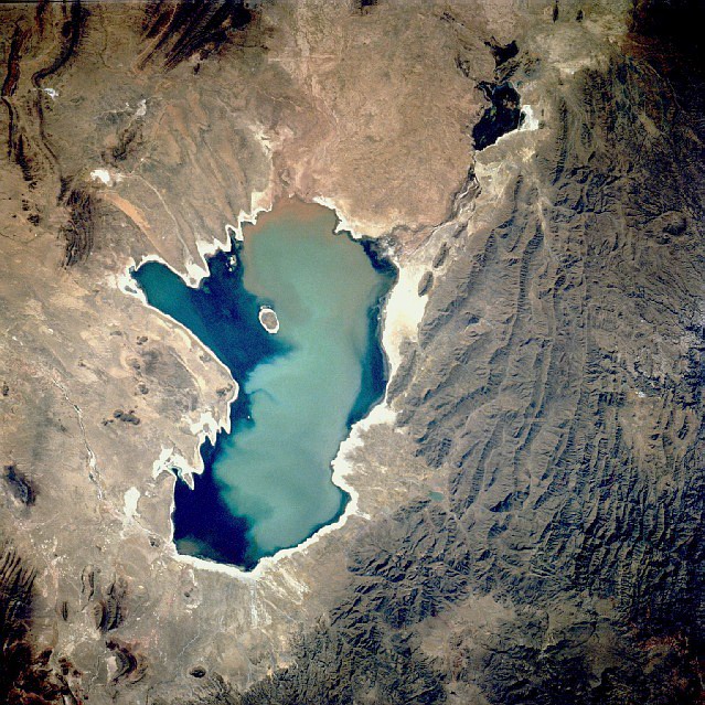 Aerial photograph of the lake in 1991 | |
 Lake Poopó  Lake Poopó | |
| Location | Altiplano |
| Coordinates | 18°33′S 67°05′W |
| Type | Endorheic salt lake |
| Native name | Lago Poopó (Spanish) |
| Primary inflows | River Desaguadero |
| Primary outflows | evaporation |
| Catchment area | 27,700 km2 (10,700 sq mi) |
| Basin countries | Bolivia |
| Surface area | 1,000 km2 (390 sq mi) |
| Average depth | >1 m (3 ft 3 in) |
| Surface elevation | 3,686 m (12,093 ft) |
| Settlements | Oruro Challapata, Huari |
 | |
Ramsar Wetland | |
| Official name | Lagos Poopó y Uru Uru |
| Designated | 11 July 2002 |
| Reference no. | 1181[1] |

In 2002 the lake was designated as a site for conservation under the Ramsar Convention.[6][7][8] By December 2015, the lake had completely dried up, leaving only a few marshy areas.[9][4][3] Although the lake has dried up completely twice in the past, it does not appear that it will recover this time.[10] Suggested causes of the decline are the melting of the Andes glaciers and loss of their waters, because of a drought due to climate change, as well as continued diversion of water for mining and agriculture.[10]
Archaeological evidence
Archaeological investigations conducted by the San Andrés University of La Paz, Bolivia, shows the influence of the Wankarani culture in the Poopó area. Complex central urban areas, such as villages and towns, were developed that expanded into the Poopó basin during the Late Formative period, (200 BC – 200 AD), probably in conjunction with changing patterns of agriculture. Herders and the life style of llama caravan merchants coexisted with more sedentary farmers in a harmonious system of exchange of goods and services.
Other investigators examining the following period, the Early Regional Developments (c. 300 – 900 AD), have concluded that the size of the inhabited areas increased. The South Poopó inhabitants developed a unique style of ceramics style with triangular spirals. The east portion of the lake has evidence of an important Tiwanaku enclave, with ceramic styles from the core Titicaca area and surrounding styles, demonstrating the interactions between different peoples in the area.[11]
Lake dynamics
The main inlet of Lake Poopó (roughly 92% of the water) comes from the Desaguadero River, which enters the lake at the north end. It flows south from Lake Titicaca. There are numerous smaller inlets along the eastern shore of the lake, many of which are dry most of the year. At times of very high water levels, Poopó is connected to the salt desert Salar de Coipasa in the west. A minor outlet leads to Salar de Uyuni in the far south of the Altiplano, but as the lake lacks any major outlet, it is classified as an endorheic basin.

When the water level of Lake Titicaca is below 3,810 m (12,500 ft), the flow of Desaguadero River is so low it can no longer compensate for the massive water losses due to evaporation from the surface of Lake Poopó. At this point, the lake volume begins to decrease. At its maximum in 1986, the lake had an area of 3,500 km2 (1,400 sq mi). During the years that followed, the surface area steadily decreased until 1994, when the lake disappeared completely. The time period between 1975 and 1992 is the longest period in recent times when the lake had a continuous water body. Renewed rainfalls in the mid-1990s revitalized the lake again.
Action has been taken in order to make the area ecologically sustainable again, with the help of funding from the European Union. But the efforts have been unable to offset other changes: since 1995 regional temperatures have risen and consequently tripled the evaporation rates. In addition, water was drawn off for mining and irrigation, compounding the problems.[12] On 20 January 2016 the area was declared a disaster zone by the Bolivian government.[13]
Salinity and geology

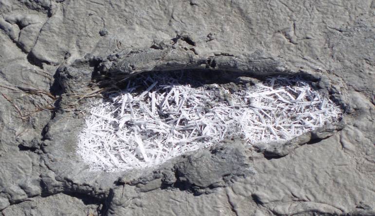
The water of Lake Poopó is highly saline. The salinity is a result of the endorheic nature of the hydrological system on the Altiplano, which allows all weathered ions to remain in the system. The salinity of Lake Poopó is further increased by the arid climate and the high evaporation from the lake surface.
In the northern end of Lake Poopó, dilution of the salinity occurs due to freshwater flow from the Desaguadero River. The salt gradient of the water increases towards the south.
The salinity varies with water volume. During October and November 2006, the salinity in the north end of the lake varied between brackish and saline (15–30,000 mg/L). In the south end of the lake the water was classified as a brine (105,000–125,000 mg/L). The water type is a 4–2 Na-(Mg)-Cl-(SO4).[clarification needed]
Geological sources of sodium chloride (NaCl), such as halite and feldspars, are present in the drainage area. These could also contribute to the salinity of Lake Poopó. The lake body is situated on top of Cenozoic deposits, consisting mainly of unconsolidated material. These sediments are the remains of extensive prehistoric lakes, which covered the Altiplano during at least five glaciation periods.
Mining and heavy metals
There is a long tradition of mining in the Poopó Basin. Extraction of metals was ordered in the 13th century to support the Inca army. After Spanish colonization in the 16th century, the mining operations increased in scale. At this point the region became known as one of the mining centres of Bolivia.
The mining districts are situated at the foothills of the Cordillera Oriental along the eastern border of the Poopó basin. The most important minerals to the economy are silver and tin.
Studies have shown elevated concentrations of heavy metals in surface and ground waters of the Poopó basin. These metals are naturally present in the bedrock, from which they are released through weathering processes. The mining activities in the area further contributes to the heavy metal pollution. Acid leaching from mines and mechanical processing of ore speed up the process.
The major part of the heavy metals transported to Lake Poopó seem to be immobilized in the bottom sediments. But concentrations of arsenic, lead, and cadmium in the lake water exceed Bolivian and World Health Organization guideline values for drinking water.
Flora and fauna
There are only three fish species in the system: the native pupfish Orestias agassizii and catfish Trichomycterus rivulatus, and the introduced silverside Odontesthes bonariensis.[14] The lake had a relatively large fish population, but by 2017 pollution and the near-complete reduction of water had all but decimated the locally important fishing industry.[15]
The aquatic bird life was very diverse, with a total of 34 species. Most famous are the three species of flamingo (Andean, James's and Chilean), which mainly lived in the shallow lagoons in the northern and eastern parts of the lake. An inventory of the bird population, made in 2000 in cooperation with BirdLife International, identified 6 threatened species and others that are near-threatened. Among these are the Andean flamingo and the Andean condor.
A total of 17 higher plants and 3 species of algae were identified in and around Lake Poopó. Due to the constant drought and flooding, the littoral zone experiences great disturbances. As a result, there was hardly any vegetation to be found on the shores of the lake.
Effects of the loss of the lake
The sparse communities nearby have suffered culturally and financially due to the local economy being dependent on lake fishing.[16][17] Moreover, many bird species native to Bolivia and internationally have been affected due to loss of food, and an annual migration area.
See also
- Desertification
- Ouki
- Tulare Lake
References
- "Lagos Poopó y Uru Uru". Ramsar Sites Information Service. Retrieved 25 April 2018.
- Machicao, Dave Sherwood y Monica (4 August 2021). "El dramático fin del segundo lago más grande de Bolivia: hoy se encuentra sin agua y convertido en un desierto". La Tercera. Retrieved 4 August 2021.
- Blair, Laurence (4 January 2018). "The ecological catastrophe that turned a vast Bolivian lake into a salt desert". The Guardian. ISSN 0261-3077. Retrieved 16 October 2020.
- Paskevics, Emily (19 December 2015). "Lake Poopó, Second Largest In Bolivia, Dries Up Completely". Headlines & Global News (HNGN). Archived from the original on 9 February 2016. Retrieved 9 February 2016.
- "Lake Poopó". Encyclopædia Britannica. Retrieved 18 July 2007.
- 11 July 2002 "Ramsar, with Bolivia's help, surpasses 200 million hectares of global coverage". Ramsar Convention Sectretariat. 2 February 2013. Archived from the original on 5 September 2015.
- "Bolivia completes Ramsar SGF project on Lake Poopó". Ramsar Convention Sectretariat. 25 February 2003. Archived from the original on 9 February 2016.
- "Climate Change Claims; a Lake, and an Identity". NYTimes. 7 July 2016. Retrieved 10 July 2016.
- Mercado, David. "Lake Poopó Dries Up". Reuters. Archived from the original on 19 December 2015.
- Valdez, Carlos; Bajak, Frank (21 January 2016). "Disappearance of Bolivia's No. 2 lake a harbinger". The News-Herald. Archived from the original on 9 February 2016.
- "Central places formation at the southern Poopó lake basin". Uppsala Universitet. Archived from the original on 9 June 2007. Retrieved 18 July 2007.
- "Lake Poopó". Encyclopædia Britannica. Retrieved 3 March 2016.
- Mururi, Manish (21 January 2016). "National disaster declared upon drying up of Lake Poopó". Biotech in Asia. Archived from the original on 22 January 2016. Retrieved 21 January 2016.
- Calizaya, A. (2009), Water resources management efforts for best water allocation in the Lake Poopo basin, Bolivia, Lund University
- Whitt, V. (30 June 2017). "Dying and Drying: The Case of Bolivia's Lake Poopó". nacla. Retrieved 23 January 2020.
- Casey, Nicholas; Haner, Josh (7 July 2016). "Climate Change Claims a Lake, and an Identity". The New York Times. ISSN 0362-4331. Retrieved 28 September 2019.
- "Bolivia's 'People of the Water' try to survive loss of lake". 9 June 2021.
- Drever, James I: The Geochemistry of Natural Waters, 3rd edition, Prentice Hall, 1997.
- Montes de Oca; Geografia y Recursos Naturales de Bolivia, 3rd Edition, EDOBOL, La Paz, 1997.
- Rocha, O.O. (editor): "Diagóstico de los recursos naturales y culturales de los lagos Poopó y Uru Uru, Oruro – Bolivia". Convención Ramsar, WCS/Bolivia, La Paz, 2002.
- Troëng, B., Riera-Kilibarda C. Mapas temáticos de recursos minerales de Bolivia, Boletin del Servicio geológico de Bolivia N 7, La Paz, 1996.
External links
- Master thesis about heavy metals in the rivers of the Poopó basin[permanent dead link]
- Master thesis about heavy metals in Lake Poopó
- Satellite images and information from NASA about Lake Poopó
- Lake Titicaca, Lake Poopó, and Salar de Uyuni, Bolivia
- Bolivia Drainage
- Bolivia's second-largest lake dries up and may be gone forever, lost to climate change – The Guardian
- Google Earth view
Lakes on the Altiplano | |
|---|---|
| Present-day lakes and salt pans |
|
| Lake expansions of Lake Titicaca | |
| Ancient lakes | |
| Other paleolakes and lake expansions in the region | |
Authority control | |
|---|---|
| General |
|
| National libraries | |
На других языках
[de] Poopó-See
Der Poopó-See ist ein rund 1340 km² großer Salzsee in den Anden in Bolivien. Die Behörden erklärten den See im Dezember 2015 offiziell für ausgetrocknet, im Februar 2017 wurde er durch starke Sommerregen zu einem großen Teil wieder aufgefüllt, jedoch 2021 wieder ausgetrocknet.[1]- [en] Lake Poopó
[es] Lago Poopó
El lago Poopó es un lago de agua salada, el segundo más grande de Bolivia después del lago Titicaca.[1][2] Ambos están conectados por el río Desaguadero. De los lagos ubicados exclusivamente en territorio boliviano es el de mayor tamaño. El 16 de diciembre de 2015 desapareció tras un acelerado proceso de desertificación, sin embargo, con las lluvias que se registraron los meses de diciembre de 2016 y los primeros meses de 2017 pudo recuperar un tercio del agua perdida.[fr] Lac Poopó
Le lac Poopó est un lac salin de Bolivie, situé à environ 3 686 mètres d'altitude sur l'Altiplano à 75 km au sud d'Oruro, dans une région de climat aride.[it] Lago Poopó
Il lago Poopó è un grande lago salato situato in una depressione superficiale nella sezione boliviana dell’altiplano ad un'altitudine di circa 3.686 metri sul livello del mare. Misura 90 km di lunghezza per 32 km di larghezza e costituisce la metà orientale del Dipartimento di Oruro, una regione mineraria nel sud-ovest della Bolivia.[ru] Поопо
Поопо́ (исп. Lago Poopó, айм. Pü Pü Quta, кечуа Puwpu qucha) — пересохшее[1][2] бессточное солёное озеро в Боливии, примерно в 130 км к югу от города Оруро.Другой контент может иметь иную лицензию. Перед использованием материалов сайта WikiSort.org внимательно изучите правила лицензирования конкретных элементов наполнения сайта.
WikiSort.org - проект по пересортировке и дополнению контента Википедии