geo.wikisort.org - Island
The Desventuradas Islands (Spanish: Islas Desventuradas,[2] IPA: [ˈizlaz ðezβentuˈɾaðas], "Unfortunate Islands" or Islas de los Desventurados, "Islands of the Unfortunate Ones"[3]) is a group of four small oceanic islands located 850 kilometres (530 mi) off the coast of Chile, northwest of Santiago in the Pacific Ocean.[4] They are considered part of Insular Chile.
Native name: Islas Desventuradas | |
|---|---|
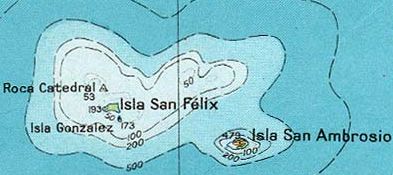 Map of Desventuradas Islands, also known as San Félix Islands | |
 Desventuradas Islands The Desventuradas Islands are part of oceanic Chile | |
| Geography | |
| Location | Chilean Sea |
| Coordinates | 26.32°S 80°W |
| Archipelago | Desventuradas |
| Adjacent to | Pacific Ocean |
| Total islands | 4 |
| Major islands | San Ambrosio, San Félix, Gonzalez and Roca Catedral |
| Area | 5.36 km2 (2.07 sq mi)(together) |
| Highest elevation | 479 m (1572 ft) max. |
| Administration | |
| Region | |
| Province | Valparaíso Province |
| Commune | Juan Fernández |
| Demographics | |
| Population | 11 |
| Additional information | |
| Time zone |
|
| • Summer (DST) |
|
| NGA UFI= -900077 "San Ambrosio" -883263 "Gonzáles" -900282 "San Félix" | |
Due to their isolation and difficulty of access there are no civilian settlements on these islands, but a detachment of the Chilean Navy is stationed on Isla San Félix, which also hosts the 2,000-metre (6,600 ft) Isla San Felix Airport.
History
Prehistory
No signs of prehistoric human activity by Polynesians or Indigenous peoples of the Americas have ever been found on the islands, or on the neighboring Juan Fernández Islands.[5] Michael Levinson's 1973 book The Settlement of Polynesia states, "the Juan Fernández Islands and San Felix and San Ambrosio were apparently unoccupied in pre-Columbian times and were not discovered by the Spanish until between 1563 and 1574. There is no evidence available to suggest that they were visited for fishing or other reasons by Amerindians before this."[6]
Discovery
The islands were possibly discovered by Ferdinand Magellan as early as 1521. The first confirmed sighting was by Juan Fernández on 6 November 1574 while voyaging from Callao to Valparaíso.[7] Pedro Sarmiento de Gamboa wrote in 1579 that "they are now called after St. Felix and St. Ambor (i.e. Felix and Nabor)". However, the name of the martyr Ambor (Nabor) became confused with that of the more famous bishop Saint Ambrose (San Ambrosio).[8][9] It is, probably, one of these islands that Captain John Davis struck one night in 1686. He was able to continue his voyage but erroneously reported the position of the incident.[10]
San Felix played a part in the Falklands War. In May 1982, the Chilean government allowed an RAF Nimrod R1 to fly signals reconnaissance sorties from the island, gathering information on Argentine Air Force movements.[11][12]
Ecology
Vegetation of the larger islands is a miniature mosaic of matorral, barren rock, various sizes of trees, and shrubs mixed with ferns and perennial herbs. Thamnoseris lacerata is an endemic shrub species. The large islands, San Félix and San Ambrosio, are home to a critical WWF recognized temperate forest biome.
The marine fauna shares close affinities with the south Pacific and the central Pacific, more so than with the nearing South America. This is partly due to the Humboldt Current, which helps create a powerful biogeographic barrier between these islands and South America.[13]
There are no permanent sources of fresh water on any of the islands. Vertebrates inhabiting both of the largest islands are limited to birds. Ten species of marine birds and one land bird species, some of them endangered, make their nests on or visit the islands. The island group has been recognised as an Important Bird Area (IBA) by BirdLife International because it is a breeding site for large numbers of Masatierra petrels.[14]
List of islands and location
The Desventuradas Islands, from east to west:
| Island/Rock | Area (km²) | Peak Elevation (m) | Geographical Coordinates | |||||
|---|---|---|---|---|---|---|---|---|
| San Ambrosio | 3.1 | 479 | 26°20′37″S 79°53′28″W | |||||
| San Felix group | ||||||||
| Islote González | 0.25 | 173 | 26°18′36″S 80°05′06″W | |||||
| San Félix | 2 | Cerro Amarillo, 193 | 26°17′30″S 80°05′42″W | |||||
| Roca Catedral | 0.01 | 53 | 26°16′25″S 80°07′15″W | |||||
| Total | 5.36 | 479 | ||||||
See also
- List of islands of Chile
- Insular Chile
References
- "Time Zone & Clock Changes in Desventuradas Islands, Chile". timeanddate.com. Retrieved 4 May 2020.
- Anderson, Athol; Haberle, Simon; Rojos, Gloria; Seelenfreund, Andrea; Smith, Ion; Worthy, Trevor (2002). "An archaeological exploration of Robinson Crusoe Island, Juan Fernandez Archipelago, Chile". In Shutler, Richard (ed.). Fifty Years in the Field: Essays in Honour and Celebration of Richard Shutler Jr's Archaeological Career. New Zealand Archaeological Association. pp. 239–249. ISBN 978-0-9597915-8-7. OCLC 606934180.
- ADM - Records of the Admiralty, Naval Forces, Royal Marines, Coastguard, and related bodies; Pacific Ocean: South America, W Coast: Chile: Islas de los Desventurados and Islas Juan Fernandez;
- "San Félix-San Ambrosio Islands temperate forests". Terrestrial Ecoregions. World Wildlife Fund.
- Flett, Iona; Haberle, Simon (2008). "East of Easter: Traces of human impact in the far-eastern Pacific" (PDF). In Clark, Geoffrey; Leach, Foss; O'Connor, Sue (eds.). Islands of Inquiry. ANU Press. pp. 281–300. CiteSeerX 10.1.1.593.8988. hdl:1885/38139. ISBN 978-1-921313-89-9. JSTOR j.ctt24h8gp.20.
- https://openresearch-repository.anu.edu.au/bitstream/1885/114825/2/b13217963.pdf [bare URL PDF]
- Delgado, James P.; Brennan, Michael L.; Rapu Haoa, Sergio A.; Rapu Leong, Julianna H.; Gaymer, Carlos F.; Carabias, Diego; Stokes, Emily; Wagner, Daniel (1 February 2022). "The hidden landscape: Maritime cultural heritage of the Salas y Gómez and Nazca ridges with implications for conservation on the high seas". Marine Policy. 136: 104877. doi:10.1016/j.marpol.2021.104877. S2CID 245223594.
- Corney, B. Glanvill (1920). "The Isles of San Felix and San Nabor". The Geographical Journal. 56 (3): 196–200. doi:10.2307/1781535. JSTOR 1781535.
- Brand, Donald D. The Pacific Basin: A History of its Geographical Explorations The American Geographical Society, New York, 1967, p.127.
- Jacques Julien Houtou de Labillardière (1800). Relation du voyage à la recherche de La Pérouse ... 1791, 1792, et pendant la Ière et la 2de année de la République françoise. 2 tom. [and] Atlas.
- "Chile". Archived from the original on 2012-04-30. Retrieved 2008-08-26.
- Alexander, Harriet (7 July 2014). "'Without Chile's help, we would have lost the Falklands'". The Telegraph. Retrieved 8 July 2014.
- "Desventuradas Islands".
- "Islas Desventuradas". BirdLife Data Zone. BirdLife International. 2021. Retrieved 22 January 2021.
External links
- GoogleMaps picture of San Felix island
- Islands of Chile @ United Nations Environment Programme
- World island information @ WorldIslandInfo.com
- South America Island High Points above 1000 meters
- Archipiélago de Las Desventuradas (Spanish)
- United States Hydrographic Office, South America Pilot (1916)
На других языках
[de] Desventuradas-Inseln
Die Desventuradas-Inseln (von span. Islas Desventuradas, etwa „Unglückliche Inseln“) sind eine kleine Inselgruppe im Pazifischen Ozean, bestehend aus den Hauptinseln San Félix und San Ambrosio sowie zwei kleineren Eilanden. Politisch gehören die Inseln zum Stadtgebiet von Valparaíso, von deren Stadtmitte sie 1.090 km (San Ambrosio) bzw. 1111 km (San Félix) entfernt liegen. Übliche Schreibweisen sind außer Desventuradas auch Desventurados oder Desaventuradas.- [en] Desventuradas Islands
[es] Islas Desventuradas
Islas Desventuradas es un archipiélago del Océano Pacífico perteneciente a Chile, a 850 km de la costa de América del Sur: el islote González, la roca Catedral y las islas San Ambrosio y San Félix. Estas dos últimas son temporalmente habitadas por isleños de Robinson Crusoe. Política y administrativamente pertenecen a la comuna de Valparaíso, habiendo sido hasta 1979 parte de la comuna de Caldera.[1][fr] Îles Desventuradas
Les îles Desventuradas, également appelées îles Malheureuses ou îles d'Infortune, sont de petites îles de l'océan Pacifique situées approximativement à 890 kilomètres des côtes du Chili à qui elles appartiennent. Les deux îles principales sont l'île San Félix et l'île San Ambrosio. Elles sont rattachées administrativement à la région de Valparaíso.[it] Isole Desventuradas
Le isole Desventuradas (in spagnolo: Islas Desventuradas) sono delle piccole isole situate nell'oceano Pacifico circa 870 km al largo delle coste del Cile; fanno parte del comune di Valparaíso.[ru] Ислас-Десвентурадас
Ислас-Десвентурадас (исп. Islas Desventuradas) — цепь из четырех небольших островов, расположенных в 850 км от побережья Чили, к северо-западу от столицы страны Сантьяго в Тихом океане[1].Другой контент может иметь иную лицензию. Перед использованием материалов сайта WikiSort.org внимательно изучите правила лицензирования конкретных элементов наполнения сайта.
WikiSort.org - проект по пересортировке и дополнению контента Википедии