geo.wikisort.org - Island
The Gulf Islands are a group of islands in the Salish Sea between Vancouver Island and the mainland coast of British Columbia.
 View from Baynes Peak on Salt Spring Island | |
| Geography | |
|---|---|
| Location | Salish Sea |
| Coordinates | 48°57′N 123°32′W |
| Major islands | 20 |
| Administration | |
Canada | |
| Province | British Columbia |
| Demographics | |
| Population | 23,497 (2016 est.) |
Etymology
The name "Gulf Islands" comes from "Gulf of Georgia," the original term used by George Vancouver in his mapping of the southern part of the archipelago and which before the San Juan Island dispute also was taken to include what have since been called the San Juan Islands.[citation needed] Strictly speaking, the Strait of Georgia is only the wide, open waters of the main strait between the mainland and Vancouver Island, and does not officially refer to the adjoining waters between the islands and Vancouver Island but has become a common misnomer for the entire Gulf, which includes waters such as Active Pass (between Galiano Island and Mayne Island), Trincomali Channel (between Galiano Island and Saltspring Island), Sansum Narrows (between Saltspring Island and Vancouver Island), and Malaspina Strait (between Texada Island and the mainland around Powell River). "The Gulf" refers to all such waters collectively, and to those communities and shores surrounding it.[1] Only the term "Strait of Georgia" remains in the provincial gazette although its use as a synonym for the Gulf is unofficial, while the term Gulf of Georgia remains in current use though not in the provincial gazette.
The term Salish Sea was adopted in 2010 to refer to the Strait of Georgia, the Strait of Juan de Fuca, Puget Sound, and all connecting and adjoining waters.[2]
Boundaries
According to BC Geographical Names (BCGNIS) the name "Gulf Islands" was originally intended and commonly understood to refer to the archipelago at the southern end of the Strait of Georgia; from Gabriola Island in the north to Saturna Island in the southeast and D'Arcy Island in the southwest. During the 1990s, however, the name began to be applied to all the islands in the Strait of Georgia, resulting in the introduction of the term "Southern Gulf Islands", which BCGNIS calls a misnomer, to distinguish the original "Gulf Islands" from the rest, which are sometimes called the "Northern Gulf Islands". BCGNIS further notes that Quadra Island is increasingly described as the "northernmost of the Gulf Islands".[3]
Island groups
The division of the Gulf Islands into two groups, the Southern and Northern Gulf Islands, is relatively common. The dividing line is approximately that formed by the city of Nanaimo on Vancouver Island, and the mouth of the Fraser River on the mainland. The islands of the Discovery Islands, Howe Sound, and Fraser River delta are not considered part of the Gulf Islands.
Southern Gulf Islands
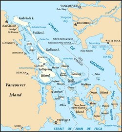
The Southern Gulf Islands are near the southern end of the Strait of Georgia, forming an intricate network of waterways between them, collectively referred to as part of the Salish Sea. The Southern Gulf Islands include hundreds of islands and islets, and form part of a larger archipelago that also includes the nearby San Juan Islands of the state of Washington in the United States.
The major Southern Gulf Islands are:
| Island | Regional district | Area (km2) | Population | Density (per km2) |
|---|---|---|---|---|
| Gabriola | Nanaimo | 57.6 | 4,500[4] | 78.1 |
| Galiano | Capital | 60.15 | 1,044 | 17.4 |
| Mayne | Capital | 21 | 1,071 | 51 |
| Moresby | Capital | 8.34 | 3 | 0.4 |
| Pender | Capital | 34 | 2,245 | 66.0 |
| Penelakut | Cowichan Valley | 8.66 | 302 | 34.9 |
| Prevost | Capital | 6.75 | ? | ? |
| Salt Spring | Capital | 182.7 | 11,635[5] | 63.7 |
| Saturna | Capital | 31 | 350 | 11.3 |
| Sidney | Capital | 8.66 | ? | ? |
| Thetis | Cowichan Valley | 10.36 | 350 | 33.8 |
| Valdes | Cowichan Valley | 9 | ? | ? |
Northern Gulf Islands

The Northern Gulf Islands are located near the northern end of the Strait of Georgia, including all islands south of Savary Island, the southernmost island of the neighbouring Discovery Islands.
The major Northern Gulf Islands are as follows:
| Island | Regional district | Area (km2) | Population | Density (per km2) |
|---|---|---|---|---|
| Ahgykson | qathet | 9.25 | 0 | 0 |
| Denman | Comox Valley | 51.03 | 1,165 | 22.8 |
| Hardy | Sunshine Coast | 7.25 | ? | ? |
| Hornby | Comox Valley | 29.97 | 958 | 32.0 |
| Lasqueti | qathet | 73.32 | 399 | 5.4 |
| Nelson | Sunshine Coast | 102.8 | ? | ? |
| Texada | qathet | 300.45 | 1,053 | 3.5 |
| Thormanby | Sunshine Coast | 8.65 | ? | ? |
Ecology

The islands and surrounding ocean are rich with ecologically diverse plants and sea life including Garry oaks, wild lilies, kelp beds and Orcas.
The Gulf Islands are home to one of the last remaining pockets of Garry oak ecosystems. Only about five percent of Garry oak ecosystems remain in their natural state, landing 91 of the approximately 350 species it supports on the province's list of species at risk. The unique Mediterranean characteristics of the islands' climate supports the Garry oak ecosystem. Garry oak ecosystems are home to more plant species, such as the camas, than any other terrestrial ecosystem in coastal B.C. and are one of Canada's most at-risk natural habitats.
Today, Garry oak meadows exist in the shallow and exposed soil of valleys, rocky foothills and southern slopes—areas that the settlers of the past 150 years have found unsuitable for agriculture or development.
The Garry Oak Ecosystems Recovery Team (GOERT), a partnership of a number of governmental and non-governmental agencies that comprise 22 individuals, was established in 1999 after the delegates of the First International Garry Oak Ecosystem Symposium met in Victoria and declared the ecosystem endangered. Since then, GOERT has been working to motivate public and private restoration of the rare ecosystem and promote conservation activities.
Conservation
The unique ecosystem of the islands has been a focal point of conservation efforts for decades. BC Parks operates a variety of provincial parks on the islands, the oldest being Mount Maxwell Provincial Park on Salt Spring Island.
In 2003, Parks Canada established Gulf Islands National Park Reserve to protect ecologically important regions of the southeastern Gulf Islands. As a National Park Reserve, the long-term goal is to protect most of the southeastern Gulf Islands.[6]
In 2012, Parks Canada published a feasibility Study for the proposed Southern Strait of Georgia National Marine Conservation Area Reserve. The goal of the National Marine Conservation Area is to protect ecologically significant marine habitats and ensure sustainable use of marine resources. It would also serve as a complement to the existing national park reserve. [7]
Agriculture

In most parts of Canada, olive trees cannot thrive; the long, harsh winter and short, humid summer and spring make it difficult for olives to grow comfortably and properly, but Pender Island, Saturna Island, and Salt Spring Island have a Mediterranean style climate that permits olive production.[8][9]
Banana Joe Clemente was one of the first Islanders to introduce olive trees to the Southern Gulf Islands in 1993 growing dozens from seed. In 1994 / 1995 planting a grove of the seed-grown olive trees around a Botchi pit on Salt Spring Island. He also distributed them to Islanders for their private gardens. Banana Joe is also responsible for introducing Musa basjoo, a hardy species of Banana plant to Salt Spring Island. Farm owner Andrew Butt planted his first olive tree in 2001 at his farm on Pender Island, using Frantoio and Leccino cultivars that he obtained from California.[9] He uses kelp obtained from the surrounding straits as fertilizer and uses a pruning method that enhances the sunlight exposure on the trees.[9] Michael Pierce and colleagues established an olive tree nursery on Saturna Island in 2009 that supplied olive trees to the region.[10]
Transportation
The larger populated islands are served by BC Ferries, which operates various vehicle and passenger ferries between the Gulf Islands and to terminals near the major cities of Nanaimo and Victoria on Vancouver Island as well as Vancouver on the mainland.
None of the islands are linked to another island by bridge, the exception being Pender Island which was artificially divided into two by a canal dug in 1903. Various proposals have been made to link one or more of the islands to another island, or with the mainland coast of the province, without success. Challenges include high capital costs, the presence of ecologically sensitive ecosystems, the mountainous terrain of the islands, impracticality due to the low population of the islands, and opposition from locals.[11][12]
See also
- List of islands of Canada
- Islands Trust
- Southern Gulf Islands Electoral Area
References
- "About the Strait • Georgia Strait Alliance".
- "Salish Sea". BC Geographical Names. Retrieved 2011-07-30.
- "Gulf Islands". BC Geographical Names. Retrieved 2011-07-30.
- Government of Canada, Statistics Canada (2022-02-09). "Profile table, Census Profile, 2021 Census of Population - Nanaimo B, Regional district electoral area (RDA) [Census subdivision], British Columbia". www12.statcan.gc.ca. Retrieved 2022-06-30.
- Government of Canada, Statistics Canada (2022-02-09). "Profile table, Census Profile, 2021 Census of Population - Saltspring Island, Regional district electoral area (RDA) [Census subdivision], British Columbia". www12.statcan.gc.ca. Retrieved 2022-06-30.
- Parks Canada Agency, Government of Canada (2017-01-26). "Park boundaries and legal description - Gulf Islands National Park Reserve". www.pc.gc.ca. Retrieved 2020-09-25.
- Parks Canada Agency, Government of Canada (2017-06-05). "Welcome - National Marine Conservation Areas". www.pc.gc.ca. Retrieved 2020-09-25.
- Mccarthy, Michael (2016-09-06). "Bananas and olives now thriving in the Banana Belt of Canada". The Province.
- Adams, Barbara (2015-03-26). "Canadian Farmer Succeeds with Olives and Gives Kelp Seaweed Some of the Credit". Olive Oil Times.
- "At the farmgate – Saturna Olive Consortium". The Province. 2014-01-25.
- "B.C. government axes bridge from Gabriola Island to Vancouver Island | News". dailyhive.com. Retrieved 2020-09-25.
- "BC decides not to build a bridge to Sunshine Coast from Metro Vancouver | Urbanized". dailyhive.com. Retrieved 2020-09-25.
External links
 Southern Gulf Islands travel guide from Wikivoyage
- Gulf Islands National Park Reserve — Parks Canada
- Come to the Islands Canadian Geographic Special Feature on B.C.'s Gulf Islands
- Southern Gulf Islands Atlas
- Islands Trust
Subdivisions of British Columbia | |||||
|---|---|---|---|---|---|
| Subdivisions |
| ||||
| Communities |
| ||||
| Metro areas and agglomerations |
| ||||
| Regions |
| ||||
| |||||
Authority control | |
|---|---|
| General |
|
| National libraries | |
На других языках
[de] Gulf Islands
Die Gulf Islands sind eine Inselgruppe in der Straße von Georgia, einem Meeresarm des Pazifiks zwischen Vancouver Island und der Küste von British Columbia. Ein Großteil der Inseln gehört zum Gulf-Islands-Nationalpark. Der Name der Inselgruppe stammt von der Bezeichnung „Gulf of Georgia“, als man die Meeresstraße noch für eine Bucht hielt.- [en] Gulf Islands
[ru] Острова Галф
Острова Галф или острова Залива (англ. Gulf Islands) — острова в проливе Джорджии (также называемом морем Салиш), между островом Ванкувер и материковой частью Британской Колумбии, Канада.Другой контент может иметь иную лицензию. Перед использованием материалов сайта WikiSort.org внимательно изучите правила лицензирования конкретных элементов наполнения сайта.
WikiSort.org - проект по пересортировке и дополнению контента Википедии