geo.wikisort.org - Island
Denman Island, or Sla-dai-aich (Taystayic), its Indigenous name, is one of the Northern Gulf Islands and part of the Comox Valley Regional District of British Columbia, Canada, and is home to a small community of 1,165 year-round residents.[1]
 Denman Island looking south from Comox | |
 Location in British Columbia 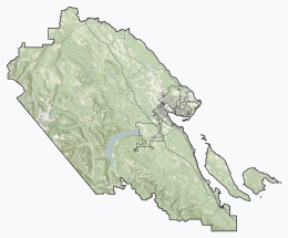 Location in Comox Valley Regional District | |
| Geography | |
|---|---|
| Location | Strait of Georgia |
| Coordinates | 49°33′N 124°48′W |
| Archipelago | Gulf Islands |
| Area | 51.03 km2 (19.70 sq mi) |
| Administration | |
Canada | |
| Province | British Columbia |
| Regional district | Comox Valley |
| Demographics | |
| Population | 1,165 (2016) |
History
Denman Island was first inhabited by Indigenous peoples including the Pentlatch and Sliammon as evidenced by middens, gravesites, and oral history. It was seen and mapped by Europeans during the 1791 voyage of the Spanish ship Santa Saturnina, under Juan Carrasco and José María Narváez.[2] It was named by Captain Richards in 1860 for Rear Admiral Joseph Denman who was commander of the Pacific station from 1864 to 1866.[3][4]
The earliest colonial settlers of Denman Island arrived during the 1870’s. Some were attracted by the establishment of the Baynes Sound Coal Mine on the Tsable River, across Baynes Sound from Denman Island. Mine construction started in 1873 and coal was shipped in 1876. Several large families migrated to Denman Island from Eastern Canada in1876 including the McFarlane, Piercy and Graham families.[5] After being briefly in production the Baynes Sound mine closed in 1877 and mine surveyer David Pickles moved to Denman Island, preempting a large wetland in the middle of the island.[6]
Denman Island life
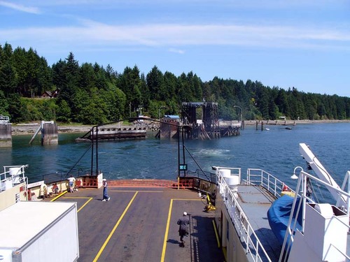
Regular ferry service links Denman Island to both Hornby Island from Gravelly Bay on the east side of Denman and across Baynes Sound via the MV Baynes Sound Connector cable ferry to Buckley Bay on Vancouver Island on the west side. "Downtown" Denman consists of one general store and Post Office, two community halls and a museum, the Dora Drinkwater Volunteer Library, a community school, an Anglican church and the Arts Centre. There is also a hardware store, craft store and a books and coffee shop.[7] Around the corner on Piercy Road is the Denman Island Health Centre.[8]
Denman Island has long been a haven for people escaping from busy urban centres.[tone][citation needed] It is known for its dances, festivals, quiet roads, and scenery.[citation needed] A number of potters, weavers and painters have made Denman Island their home for decades.[9] The island has a land area of 51.03 square kilometres (19.70 sq mi).
The author Emily St. John Mandel spent most of her childhood on Denman Island.[10]
Vegetation and soils
The western part of Denman Island is covered by a dense forest dominated by Douglas fir, western hemlock, and western red cedar on deep loamy glacial till or marine deposits mapped as Royston gravelly loam or Tolmie-Merville complex. Some areas have shallow soils over sedimentary rock and are mapped as Haslam shaly loam or Rough Stony-Haslam complex. The eastern part has a loamy sand (Kye-Qualicum complex or Bowser series) on which arbutus is frequently present near the shore. Poorly drained depressions are mapped as Tolmie loam, Parksville sandy loam, or Arrowsmith peat.[11]
Denman Island Disease
An infectious disease among Pacific oysters was identified in 1960 off Denman Island. The disease causes visible yellow/green pustules on the body and adductor muscles of the oysters therefore reducing marketability of the oysters. It was found that the causative agent of these lesions are associated with microcells, which were later identified as Mikrocytos mackini.[12]
Provincial Parks located on Denman Island

- Sandy Island Marine Provincial Park (off northern tip, accessible on foot at low tide).
- Fillongley Provincial Park – B.C. Ministry of Environment Site
- Boyle Point Provincial Park – B.C. Ministry of Environment Site
- Denman Island Park and Protected Area – B.C. Ministry of Environment Site
Local media
Denman Island has a monthly news and artistic journal called the Flagstone,[13] a weekly news and advertising circular called the Grapevine,[14] a community radio station, CKLR-FM, and several active online groups, including the Denman Open Bulletin Board.[citation needed]
References
- Population calculated by combining the populations of Dissemination Areas 59260347 (666) and 59260348 (499)
- McDowell, Jim (2015). Uncharted Waters, The Explorations of Jose Narvaez (1768 - 1840). Vancouver, BC, Canada: Ronsdale Press. pp. 146–148. ISBN 978-1-55380-434-5.
- "Denman Island". BC Geographical Names.
- Richards, Captain G.H. (2012). Dorricott1 Cullon2, Linda1 Deidre2 (ed.). The Private Journal of Captain G.H. Richards, The Vancouver Island Survey (1860-1862). Vancouver BC Canada: Ronsdale Press. p. 33. ISBN 9781553801276.
- Mackie, Richard Somerset (1995). The Wilderness Profound, Victorian life on the Gulf of Georgia. Victoria BC Canada: Sono Nis Press. pp. 189, 190. ISBN 1-55039-058-9.
- Isenor1 McInnes2 Stephens3 Watson4, D.E.1 W.N.2 E.G.3 D.E4 (1987). Land of Plenty A History of the Comox District. Campbell River, BC Canada: Ptarmigan Press. p. 115. ISBN 978-0-919537-45-3.
- "About Denman Island". Visit Denman Island. 11 November 2022. Retrieved 11 November 2022.
- "Denman Island Health Centre". islandhealth.ca/our-locations. Retrieved 11 November 2022.
- "Denman Craft Shop". Visit Denman Island. Retrieved 2022-10-14.
- Kirch, Claire (9 March 2012). "Emily St. John Mandel: Once a Dancer, Now a Noir Phenom". Publishers Weekly. Retrieved 30 September 2015.
- Canada, Government of Canada; Agriculture and Agri-Food (1959). "Soil Survey of Southeast Vancouver Island and Gulf Islands, British Columbia". Retrieved 2018-03-11.
- Elston, R; Friedman, C; Gustafson, L; Meyer, G; Rogers, R (2015-05-21). "Denman Island disease in Washington State, USA: distribution and prevalence in Pacific and Olympia oysters". Diseases of Aquatic Organisms. 114 (2): 147–154. doi:10.3354/dao02862. ISSN 0177-5103. PMID 25993889.
- "The Flagstone". Denman Job Board. 22 October 2015. Retrieved 13 March 2022.
- "Home". The Islands Grapevine. Retrieved 13 March 2022.
Further reading
- Day, J.H., L. Farstad, and D.G. Laird, 1959. Soil Survey of Southeast Vancouver Island and Gulf Islands, British Columbia. B.C. Soil Survey, Rept. No. 6, Can. Dept. Agric.
- Denman Island Trust Area, Comox-Strathcona K Regional District Electoral Area, British Columbia; Statistics Canada
External links
- Association of Denman Island Marine Stewards
- Denman Conservancy Association
- Hornby& Denman Community Health Care Society}
- https://denmanmuseum.ca/wp-content/uploads/2020/05/Names.pdf
| Authority control: National libraries |
|---|
На других языках
[de] Denman Island
Die Insel Denman Island gehört zum nördlichen Teil der Gulf Islands in der kanadischen Provinz British Columbia und liegt zwischen dem Festland und Vancouver Island. Vom westlich gelegenen Vancouver Island wird die Insel durch den etwa 2 Kilometer breiten Baynes Sound getrennt. Von ihrer östlichen Nachbarinsel Hornby Island ist sie durch den etwa 1,5 Kilometer breiten Lambert Channel getrennt.- [en] Denman Island
[fr] Île Denman
L'île Denman est une des îles Gulf. Elle fait partie du district régional de Comox Valley en Colombie-Britannique.Другой контент может иметь иную лицензию. Перед использованием материалов сайта WikiSort.org внимательно изучите правила лицензирования конкретных элементов наполнения сайта.
WikiSort.org - проект по пересортировке и дополнению контента Википедии