geo.wikisort.org - Mountains
The Sierra Madre Oriental (Spanish: [ˈsjera ˈmaðɾe oɾjenˈtal] (![]() listen)) is a mountain range in northeastern Mexico. The Sierra Madre Oriental is part of the American Cordillera, a chain of mountain ranges (cordillera) that consists of an almost continuous sequence of mountain ranges that form the western "backbone" of North America, Central America, South America, and Antarctica.
listen)) is a mountain range in northeastern Mexico. The Sierra Madre Oriental is part of the American Cordillera, a chain of mountain ranges (cordillera) that consists of an almost continuous sequence of mountain ranges that form the western "backbone" of North America, Central America, South America, and Antarctica.
| Sierra Madre Oriental | |
|---|---|
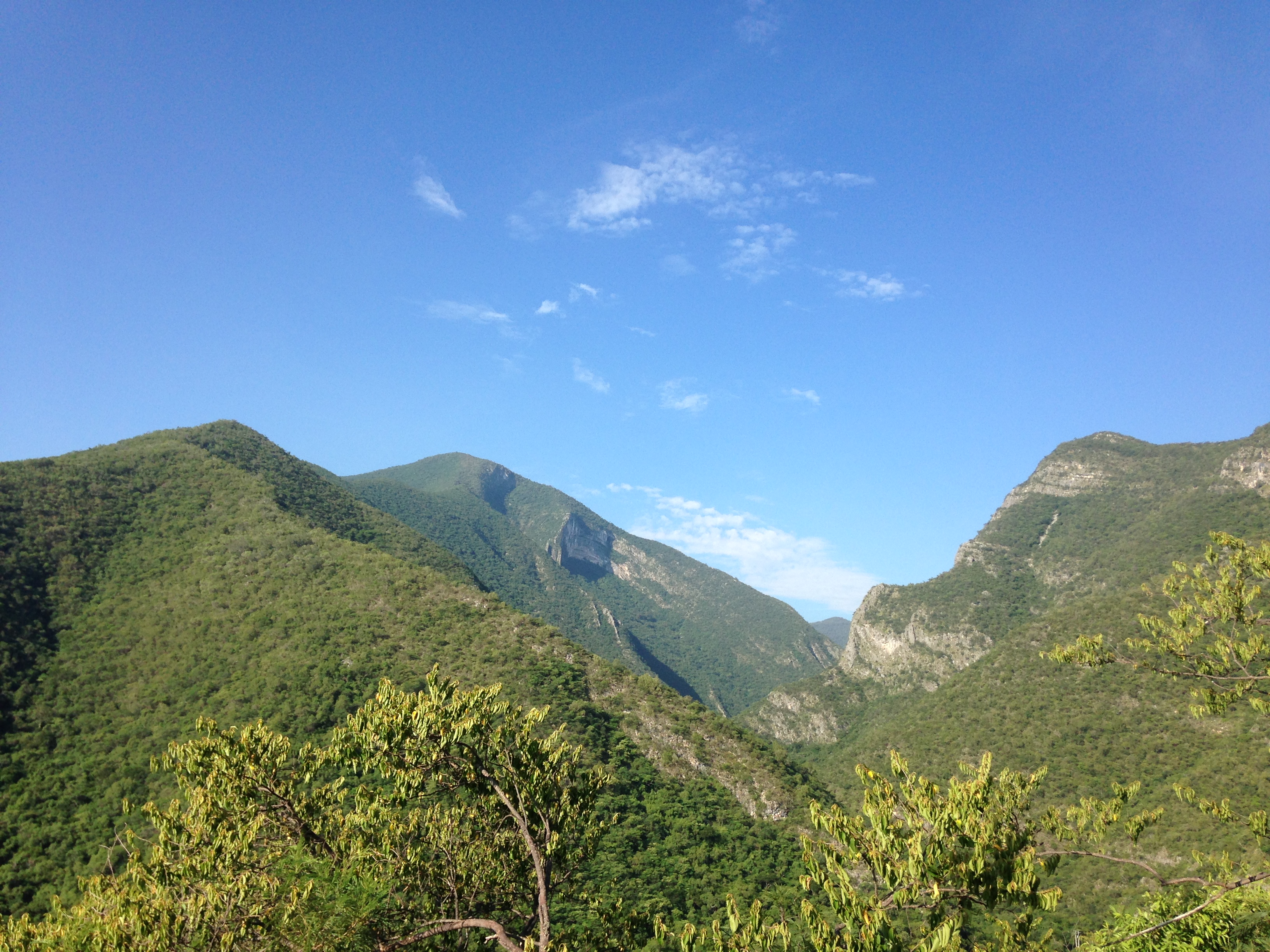 Sierra Madre Oriental near Ciudad Victoria, Tamaulipas | |
| Highest point | |
| Peak | Cerro San Rafael |
| Elevation | 3,700 m (12,100 ft) |
| Prominence | 1,855 m (6,086 ft) |
| Coordinates | 25°22′N 100°33′W |
| Geography | |
| |
| Country | Mexico |
| States | Coahuila, Nuevo León, Tamaulipas, San Luis Potosí, Hidalgo, Puebla and Querétaro |
Setting
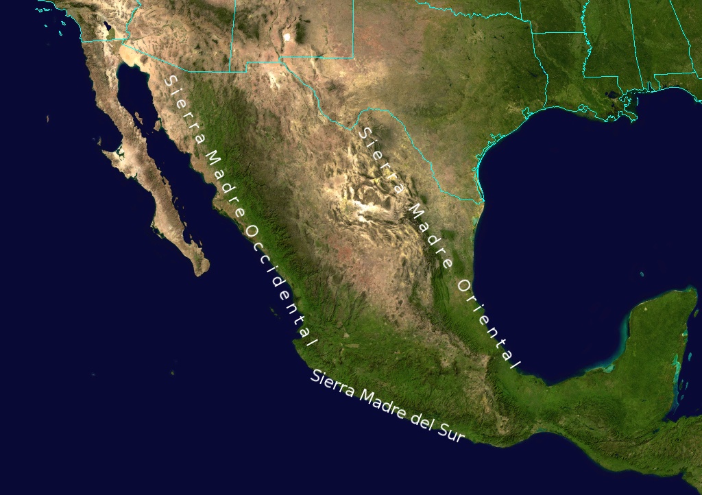
Spanning 1,000 kilometres (620 mi) the Sierra Madre Oriental runs from the Rio Grande on the border between Coahuila and Texas south through Nuevo León, southwest Tamaulipas, San Luis Potosí, Querétaro, and Hidalgo to northern Puebla, where it joins with the east-west running Eje Volcánico Transversal of central Mexico. The northernmost are the Sierra del Burro and the Sierra del Carmen which reach the border with the United States at the Rio Grande. North of the Rio Grande, the range continues northwestward into Texas and beyond as the Davis and Guadalupe Ranges.

Mexico's Gulf Coastal Plain lies to the east of the range, between the mountains and the Gulf of Mexico coast. The Mexican Plateau, which averages 1,100 metres (3,600 ft) in elevation, lies between the Sierra Madre Oriental and the Sierra Madre Occidental further west.
The climate of the Sierra Madre Oriental is drier than the rainforest areas further south. The Serranias del Burro in the northern range is much drier, semi-arid to arid, yet annually orographically induces and/or intensifies notably vigorous thunderstorm activity in April and May. This small region consistently is a particularly active area for supercells with significantly severe hail and tornadoes, which first form over to just leeward of the mountains then move eastward, sometimes hundreds of kilometres (miles) past the Rio Grande River into Texas.[1][2]

Highest major summits
Cerro San Rafael, at 3,700 metres (12,100 ft) above sea level (ASL), is the highest point of the Sierra Madre Oriental and the state of Coahuila and the second in Mexico in isolation.[3][4]
| Rank | Mountain Peak | State | Mountain Range | Elevation | Prominence | Isolation |
|---|---|---|---|---|---|---|
| 1 | Cerro San Rafael[5] PB | Sierra Madre Oriental | 3700 m 12,139 feet |
1855 m 6,086 feet |
628 km 390 miles | |
| 2 | Sierra de la Marta[6] PB | Sierra Madre Oriental | 3700 m 12,139 feet |
NA | 607 km 377 miles | |
| 3 | Cerro el Potosí PB | Sierra Madre Oriental | 3700 m 12,139 feet |
1380 m 4,528 feet |
570 km 354 miles | |
Ecology
This long range of tall mountains is noted for its abundant biodiversity and large number of endemic species of plants and wildlife, from the dry north to the wetter south. The Sierra Madre Oriental pine-oak forests are found at high elevations in the range (1,000–3,500 m or 3,300–11,500 ft above sea level).[7] To the east, the Tamaulipan matorral occupies the range's lower slopes in Nuevo León and northern Tamaulipas, while the Veracruz moist forests cover the lower slopes of the central range, and the eastern slopes at the southern end of the range are home to the Veracruz montane forests. West of the range, the Mexican Plateau is home to deserts and xeric shrublands, including the Chihuahuan Desert to the north, the Meseta Central matorral on the central part of the plateau, and the Central Mexican matorral on the southern plateau.
Much of the wildlife can also be found in the Sierra Madre Occidental, which runs parallel to these mountains along western Mexico.
 Road into the cloud forest of El Cielo Biosphere Reserve, Municipality of Gómez Farías, Tamaulipas, Mexico (16 April 2001)
 Gravel road through the arid interior slopes of the Sierra Madre Oriental, Municipality of Miquihuana, Tamaulipas, Mexico (10 August 2003)
 Looking down on the Marcela valley from Sierra Peña Navada, Municipality of Miquihuana, Tamaulipas, Mexico (10 August 2003)


Flora
Pine-oak forests are dominated by several species of pine, such as Pinus nelsonii, P. cembroides, P. pseudostrobus, and P. arizonica, and oak, such as Quercus castanea and Q. affinis.[7] Matorral is characterized by woody shrubs, small trees, cacti, and succulents. Montane chaparral is found above 1,700 m (5,600 ft) and is home to species in the genera Quercus, Arbutus, Yucca, Cercocarpus and Bauhinia. Piedmont scrub occurs below 2,000 m (6,600 ft) and is composed of plants 3 to 5 m (9.8 to 16.4 ft) in height such as Helietta parvifolia, Neopringlea integrifolia and Acacia spp.[8] The canopy of moist forests is dominated by trees up to 30 m (98 ft) in height, including Brosimum alicastrum, Manilkara zapota, Celtis monoica, Bursera simaruba, Dendropanax arboreus, and Sideroxylon capiri.[9]
Fauna
Birds of the forest include the Mexican chickadee, Montezuma quail, Strickland's woodpecker, zone-tailed hawk and several species of jay.
Pine-oak forests in Coahuila are part of the migration route of monarch butterflies (Danaus plexippus).[7]
Threats and conservation
Original habitats have been severely reduced by clearance for livestock grazing and logging over hundreds of years. Protected areas include the Cumbres de Monterrey National Park in Mexico and the Big Bend National Park in Texas. The El Cielo Biosphere in Tamaulipas preserves the northernmost tropical Veracruz moist forests in Mexico and extensive temperate cloud forests.[10]
See also
- Mountain peaks of Mexico
- Sierra Madre Occidental
References
- Edwards, Roger (8 November 2006). "Supercells of The Serranias Del Burro (Mexico)". 23rd Conference on Severe Local Storms. St. Louis, MO: American Meteorological Society.
- Weiss, Joshua D. (30 October 2008). "Supercells of The Serranias Del Burro (Mexico)". 24th Conference on Severe Local Storms. Savanna, GA: American Meteorological Society.
- "Cerro San Rafael - Peakbagger.com". peakbagger.com. Retrieved 27 May 2016.
- "Sierra Madre Oriental". peakbagger.com. Retrieved 27 May 2016.
- The summit of Cerro San Rafael is the highest point of the Sierra Madre Oriental and the state of Coahuila.
- The summit of Sierra de la Marta on the border with Coahuila is the highest point of the state of Nuevo León.
- "Sierra Madre Oriental pine-oak forests". Terrestrial Ecoregions. World Wildlife Fund. Retrieved 2010-08-22.
- "Tamaulipan matorral". Terrestrial Ecoregions. World Wildlife Fund. Retrieved 2010-08-22.
- "Veracruz moist forests". Terrestrial Ecoregions. World Wildlife Fund. Retrieved 2010-08-22.
- "Gomez Farias Region and El Cielo Biosphere Reserve", "CPD: Middle America, Site MA9, Gómez Farías Region and el Cielo Biosphere Reserve". Archived from the original on 2015-03-05. Retrieved 2014-12-18., accessed 18 Dec 2014
External links
- "Sierra Madre Oriental pine-oak forests". Terrestrial Ecoregions. World Wildlife Fund.
Geography topics | |||||||||
|---|---|---|---|---|---|---|---|---|---|
| |||||||||
| Branches |
| ||||||||
| Techniques and tools |
| ||||||||
| Institutions |
| ||||||||
| Education |
| ||||||||
| |||||||||
Physical geography | ||
|---|---|---|
|  | |
| ||
Authority control | |
|---|---|
| General |
|
| National libraries | |
| Other |
|
На других языках
[de] Sierra Madre Oriental
Die Sierra Madre Oriental ist ein Gebirgszug im Nordosten Mexikos, der sich über etwa 1250 km in den Bundesstaaten Coahuila, Nuevo León, Tamaulipas, San Luis Potosí, Hidalgo bis in den Norden der Bundesstaaten Puebla und Querétaro erstreckt und sich dort mit der Sierra Volcánica Transversal Zentralmexikos vereinigt. Der Gebirgszug verläuft jedoch weiter in südöstlicher Richtung und endet in den immer noch teilweise über 3000 m hohen Bergen der Sierra Norte de Oaxaca.- [en] Sierra Madre Oriental
[es] Sierra Madre Oriental
La Sierra Madre Oriental es una cordillera de aproximadamente 1,300 kilómetros de longitud con eje orográfico que corre en dirección noroeste - sureste y se extiende desde el río Bravo hasta unirse con el Eje Neovolcánico. Más o menos paralela a la costa del Golfo de México, al este limita con la llanura costera del golfo, y al oeste con la Altiplanicie Mexicana. La Sierra Madre Oriental atraviesa los estados de Coahuila, Nuevo León, Tamaulipas, Texas, San Luis Potosí, Hidalgo, Puebla, Querétaro, Tlaxcala y Veracruz.[1][fr] Sierra Madre orientale
La sierra Madre orientale est une chaîne de montagnes mexicaine.[it] Sierra Madre Orientale
La Sierra Madre Oriental è una catena montuosa del Messico nord-orientale.[ru] Восточная Сьерра-Мадре
Восто́чная Сье́рра-Ма́дре[2][3] (исп. Sierra Madre Oriental) — горная система на северо-востоке Мексики, расположенная на восточном краю Мексиканского нагорья. Представляет собой систему параллельных хребтов длиной около 1000 км. В северной части представлена несколькими хребтами высотой от 1000 до 3000 м. В центре и на юге хребты разделяются на отдельные массивы высотой до 4000 м. На востоке горы круто обрываются к береговой равнине Мексиканского залива, на запад к внутренним частям нагорья местами отходят отроги. Сложены верхнемезозойскими осадочными породами.Другой контент может иметь иную лицензию. Перед использованием материалов сайта WikiSort.org внимательно изучите правила лицензирования конкретных элементов наполнения сайта.
WikiSort.org - проект по пересортировке и дополнению контента Википедии