geo.wikisort.org - Island
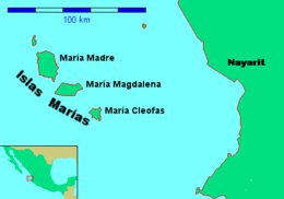
The Islas Marías ("Mary Islands") are an archipelago of four islands that belong to Mexico. They are located in the Pacific Ocean, some 100 km (62 mi) off the coast of the state of Nayarit and about 370 km (230 mi) southeast of the tip of Baja California.[1] They are part of the municipality (municipio) of San Blas, Nayarit. The islands were used as a penal colony until February 18, 2019 when President Andrés Manuel López Obrador ordered the closure of its operation as Islas Marías Federal Prison.
 | |
| Geography | |
|---|---|
| Location | Pacific Ocean |
| Coordinates | 21°31′N 106°29′W |
| Archipelago | Islas Marías |
| Total islands | 9 |
| Major islands | María Madre, María Magdalena, María Cleofas and San Juanito |
| Area | 244.970 km2 (94.583 sq mi) |
| Highest elevation | 616 m (2021 ft) |
| Highest point | Punta Rocallosa |
| Administration | |
Mexico | |
| State | Nayarit |
| Municipality | San Blas, Nayarit |
| Largest settlement | Puerto Balleto (pop. 602) |
| Demographics | |
| Population | 1,116 (2005) |
| Pop. density | 7.68/km2 (19.89/sq mi) |
The first European to discover the islands was Diego Hurtado de Mendoza, a cousin of Hernán Cortés in 1532, who gave them the name Islas Magdalenas. He found no evidence of prior habitation by the Native Americans.
In 2010 the archipelago was designated the Islas Marías Biosphere Reserve by UNESCO.[2][3]
Geography
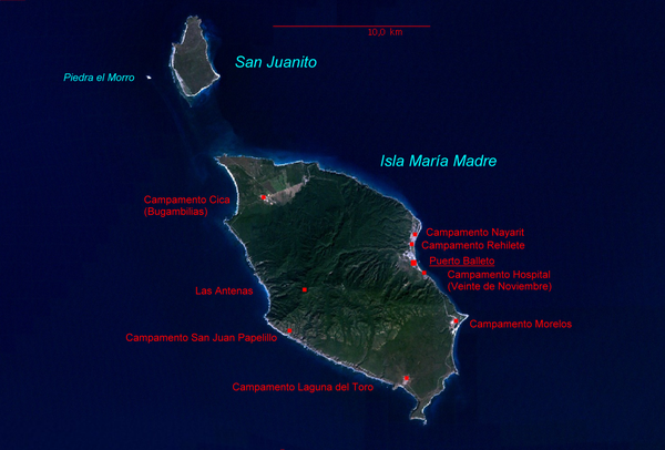
The islands have an aggregate area of 244.97 km2 (94.58 sq mi) and a population of 1,116 on Isla María Madre as of the census of 2005 along with around 8,000 prisoners. The other islands are uninhabited. The main settlement is Puerto Balleto, with a population of 602.
Isla María Madre is the largest of the islands, with an area of 145.28 km2 (56.09 sq mi). It houses the Islas Marías Federal Prison, which was established there in 1905. The next two largest islands are Isla María Magdalena (70.44 km2 [27.20 sq mi]) and, further south, Isla María Cleofas (19.82 km [12.32 mi]). They were named after three women called Mary in the Biblical New Testament: respectively, Mary, the mother of Jesus, Mary Magdalene, and Mary, the wife of Cleopas, and are referred to as the Tres Marias. A smaller island, San Juanito, with an area of 9.1 km2 (3.5 sq mi) lies off the north coast of Isla María Madre.
The islands are listed from north to south in the following table:
| Island or Rock | Area km2 | Height m | Location |
|---|---|---|---|
| San Juanito | 9.105 | . | 21°44′48″N 106°40′41″W |
| Piedra El Morro | 0.060 | . | 21°44′17″N 106°42′11″W |
| María Madre | 145.282 | 616 | 21°36′57″N 106°34′42″W |
| Isla Don Boni | 0.025 | . | 21°32′30″N 106°32′0″W |
| María Magdalena | 70.440 | 457 | 21°27′44″N 106°25′48″W |
| María Cleofas | 19.818 | 402 | 21°18′44″N 106°14′51″W |
| Piedra Blanca | 0.172 | . | 21°19′1″N 106°17′9″W |
| Roca Blanca | 0.034 | . | 21°17′44″N 106°16′7″W |
| unnamed rock | 0.034 | . | 21°17′52″N 106°16′35″W |
| Islas Marías | 244.970 | 616 | 21°32′N 106°28′W |
Geology
Research supports the hypothesis that the Islas Marias are fragments of continental crust left over from the separation of the Baja California Peninsula from the mainland of Mexico. Rocks found on the islands correspond with rocks found around Cabo San Lucas, as well as Puerto Vallarta.[4]
Fauna
Animal species endemic to the Islas Marías include the Tres Marías amazon parrot, Tres Marias hummingbird and Tres Marias island mouse, in addition to the Tres Marias raccoon, a subspecies of common raccoon.
Populated places
All populated places of the Islas Marías are on Isla María Madre. They are listed from north to south in the following table:
 | ||||||||||||||||||||||||
|---|---|---|---|---|---|---|---|---|---|---|---|---|---|---|---|---|---|---|---|---|---|---|---|---|
| Populated Place | Population (Census 2005) | Location | ||||||||||||||||||||||
| Punta el Morro | - | 21°41′45″N 106°39′19″W | ||||||||||||||||||||||
| Venustiano Carranza (Serradero, Aserradero) | - | 21°40′45″N 106°36′45″W | ||||||||||||||||||||||
| Campamento Cica (Bugambilias) | 190 | 21°40′15″N 106°37′45″W | ||||||||||||||||||||||
| Campamento Nayarit | 51 | 21°39′0″N 106°32′20″W | ||||||||||||||||||||||
| Campamento Rehilete | 71 | 21°38′44″N 106°32′29″W | ||||||||||||||||||||||
| Puerto Balleto (Isla María Madre) | 602 | 21°37′58″N 106°32′21″W | ||||||||||||||||||||||
| Zacatal | - | 21°37′44″N 106°35′26″W | ||||||||||||||||||||||
| Camarón | - | 21°37′26″N 106°37′55″W | ||||||||||||||||||||||
| Campamento Hospital (Veinte de Noviembre) | 53 | 21°37′34″N 106°31′55″W | ||||||||||||||||||||||
| Las Antenas | 2 | 21°37′15″N 106°36′18″W | ||||||||||||||||||||||
| Campamento Morelos (José María Morelos) | 98 | 21°36′4″N 106°30′47″W | ||||||||||||||||||||||
| Campamento San Juan Papelillo | 18 | 21°35′30″N 106°36′26″W | ||||||||||||||||||||||
| Borbollón (Borbollones) | - | 21°34′15″N 106°31′0″W | ||||||||||||||||||||||
| Campamento Laguna del Toro | 31 | 21°34′8″N 106°32′37″W | ||||||||||||||||||||||
| Punta Halcones | - | 21°32′45″N 106°32′30″W | ||||||||||||||||||||||
| Isla María Madre | 1,116 | 21°36′57″N 106°34′42″W | ||||||||||||||||||||||
Each populated center features a different economic activity. The primary population center is Puerto Balleto, the location of the administrative offices and the primary centers of commerce and recreation. It is subdivided into four jefaturas:
- Balleto, 21°38′2″N 106°32′21″W
- Bellavista, 21°38′19″N 106°32′30″W
- Unit Habitacional Miguel Hidalgo (UHMH), 21°38′13″N 106°32′26″W
- Primero de Mayo, 21°38′20″N 106°32′23″W
In addition to prisoners, on Maria Madre island there are employees of diverse institutions of the federal government, such as the Secretariat of Public Education, the Secretariat of the Environment, the Secretariat of Communications and Transport, post office, and the Secretariat of the Navy. Another group of settlers is made up of religious ministers and acolytes of the Catholic Church, nuns of the Order of Social Service, and invited teachers, technicians and their relatives.
The colony is governed by a state official who is both the governor of the islands and chief judge. The military command is independent and is exercised by an officer of the Mexican Navy.
Weather
The mean temperature of island remain between 84 and 89 degrees Fahrenheit throughout the year.[5] In April, May, and June sometimes temperatures cross the limit of thirty-five degrees Celsius. In December, January, and February the temperatures remain under twenty-five degrees. Sometimes the temperature may drop under twenty degrees Celsius. Most of the time weather remains dry but July, August, and September may receive rain up to 10mm. The average wind speed is between twelve and nineteen km/hour. The below chart shows the maximum and minimum temperature.
| Unit | Celsius | Celsius | Celsius | Celsius | Celsius | Celsius | Celsius | Celsius | Celsius | Celsius | Celsius | Celsius | |
| Mean | Daily Max | 29 | 29 | 31 | 32 | 34 | 34 | 32 | 31 | 31 | 31 | 31 | 29 |
| Mean | Daily Min | 13 | 14 | 15 | 17 | 19 | 22 | 24 | 24 | 24 | 22 | 18 | 15 |
| Month | Jan | Fab | March | April | May | June | July | August | September | October | November | December |
Hurricane Willa
Hurricane Willa passed through the Islas Marias on October 23, 2018. The National Hurricane Center reported at 9 AM MDT "Aircraft finds the core of Willa passing over Las Islas Marias Mexico".[6] A subsequent report from the NHC stated that "Life-threatening storm surge is occurring along the coasts of the Isla Marias'.[7] The NHC also reported that "An automated observing site on Las Islas Marias recently reported a sustained wind of 88 mph (142 km/h) with a gust to 112mph (180 km/h)".[8]
Lighthouse
There is a lighthouse located on a ridge above Puerto Balleto on Isla María Madre.[9] The height of tower is two hundred feet or sixty-two meters. The lighthouse main gallery is painted white while the tower of the lighthouse is colored in red and white.[9] The lighthouse is made of concrete and a large single story keeper house is also constructed with the lighthouse. The light house shines two white flashes every 10 seconds. The diameter of the light house is seven meters.[9]
Prison of Isla Maria
The Islas Marías Federal Prison was constructed in 1905.[1] One of its more notable prisoners was the Mexican progressive writer Jose Revueltas who wrote his first book Los Muros de Agua (The Walls of Water, publ.1941) while incarcerated there.
President of Mexico Andrés Manuel López Obrador announced on February 18, 2019, that his administration would close the Islas Marías Federal Prison, replacing it with a new cultural center that will be named for José Revueltas.[10]
See also
- Tres Marias raccoon
- Tres Marias island mouse
- Tres Marías amazon parrot
Notes
- "Marías Islands | archipelago, Mexico". Encyclopedia Britannica. Retrieved 2018-08-07.
- "Designation of New Biosphere Reserves". UNESCO. 17 June 2010. Retrieved 13 June 2016.
- "Islas María". UNESCO. Retrieved 13 June 2016.
- "Islas Marias Archipelago, Mexico. A Missing Piece to Reconstruct the Paleoposition of Baja California", Valerie Pompa-Mera, et al, Researchgate, 2011
- "Climate Puerto Balleto (Isla María Madre)". meteoblue. Retrieved 2018-08-07.
- [National Hurricane Center, Hurricane Willa, Public Advisory 14, 9 AM MDT]
- National Hurricane Center, Hurricane Willa, Discussion 15, October 23, 2018, 3 PM MDT
- National Hurricane Center, Hurricane Willa, Advisory 15, October 23, 2018, 3 PM MDT
- Rowlett, Russ. "Lighthouses of Mexico: Northwest Coast". The Lighthouse Directory. University of North Carolina at Chapel Hill. Retrieved 2018-08-07.
- [San Francisco Chronicle, February 19, 2019, p.A-2]
References
- Link to tables of population data from Census of 2005, Nayarit INEGI: Instituto Nacional de Estadística, Geografía e Informática
- Mexican islands with areas and coordinates
- map
External links
- Article from Mexico Desconocido
- Article from Ocean Dots at the Wayback Machine (archived December 23, 2010)
World Heritage Sites in Mexico | ||
|---|---|---|
| North West |
| |
| North Central |
| |
| West |
| |
| East |
| |
| South West |
| |
| South Central |
| |
| South East |
| |
| ||
На других языках
[de] Marias-Inseln
Die Marias-Inseln (spanisch Islas Marías auch Islas Tres Marías) sind eine im Pazifik vor der mexikanischen Westküste gelegene Inselgruppe. Sie gehören zum Bundesstaat Nayarit und beinhalten das Gefängnis Colonia Penal Federal Islas Marías. Die Inseln haben den Status eines mexikanischen Biosphärenreservat.- [en] Islas Marías
[es] Islas Marías
Las islas Marías, también llamadas islas Tres Marías, son un grupo de islas localizadas en el océano Pacífico a 112 km de las costas del estado mexicano de Nayarit, al que administrativamente pertenecen de facto y jurisdiccionalmente son federales (de jure), ya que poseen su propio Estatuto.[it] Isole Marías
Le Isole Marías sono un arcipelago di quattro isole localizzato nell'Oceano Pacifico a 112 km dalle coste dello Stato messicano di Nayarit, dalle quali dipendono.[ru] Лас-Трес-Мариас
Лас-Трес-Мари́ас[1][2] (исп. Islas Marías) — острова в Тихом океане, у западного побережья Мексики (штат Наярит, муниципалитет Сан-Блас).Другой контент может иметь иную лицензию. Перед использованием материалов сайта WikiSort.org внимательно изучите правила лицензирования конкретных элементов наполнения сайта.
WikiSort.org - проект по пересортировке и дополнению контента Википедии