geo.wikisort.org - Mountains
The Alpide belt or Alpine-Himalayan orogenic belt,[1] or more recently and rarely the Tethyan orogenic belt, is a seismic and orogenic belt that includes an array of mountain ranges extending for more than 15,000 kilometres (9,300 mi) along the southern margin of Eurasia, stretching from Java and Sumatra, through the Indochinese Peninsula, the Himalayas and Transhimalayas, the mountains of Iran, Caucasus, Anatolia, the Mediterranean, and out into the Atlantic.[2] It includes, from west to east, the major ranges of the Atlas Mountains, the Alps, the Caucasus Mountains, Alborz, Hindu Kush, Karakoram, and the Himalayas. It is the second most seismically active region in the world, after the circum-Pacific belt (the Ring of Fire), with 17% of the world's largest earthquakes.[2]
| Alpide belt | |
|---|---|
| Alpine-Himalayan orogenic belt | |
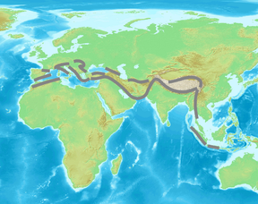 Approximate extent of the Alpide orogenic system. | |
| Highest point | |
| Peak | Mount Everest |
| Elevation | 8,848.86 m (29,031.7 ft) |
| Dimensions | |
| Length | 15,000 km (9,300 mi) E–W on the west, N–S on the east |
| Naming | |
| Etymology | Alpide is a neologism of Eduard Suess, from Alp-, "the Alps," and -ide, an innovated suffix expanding "Alps" to other ranges being grouped with it. The term "belt" signifies that the Alpides, wherever they may be, are an extended zone. |
| Geography | |
| Mesozoic oceanic platform | Southern Eurasia, northern Africa, central Asian subcontinent, southeast Asia |
| Geology | |
| Formed by | compressive forces at aligned convergent plate boundaries |
| Orogeny | If "Alpide" is taken in Kober's sense to mean the last and current of a collective group of contemporaneous ridges over the entire Tethyan region, then "Alpine orogeny" is used collectively of all the orogenies required to create the Alpides, a definition that is far from the original meanings of Alpide and Alpine, representing a specialized geologic usage. |
| Mountain type | Folded mountain ranges |
The belt is the result of Mesozoic-to-Cenozoic-to-recent closure of the Tethys Ocean and process of collision between the northward-moving African, Arabian and Indian Plates with the Eurasian Plate.[1] Each collision results in a convergent boundary, a topic covered in plate tectonics. The approximate alignment of so many convergent boundaries trending east to west, first noticed by Eduard Suess, suggests that once many plates were one plate, and the collision formed one subduction zone, which was oceanic, subducting the floor of Tethys. Suess called the single continent Gondwana, after some rock formations in India, then part of the supercontinent of Gondwana, which had earlier divided from another supercontinent, Laurasia, and was now pushing its way back. Eurasia descends from Laurasia, the Laurentia part having split away to the west to form the Atlantics. As Tethys closed, Gondwana pushed up ranges on the southern margin of Eurasia.
Brief history of the concept
The Alpide belt is a concept from modern historical geology, the study in geologic time of the events that shaped the surface of the Earth.[3] The topic began suddenly in the mid-19th century with the evolutionary biologists. The early historical geologists, such as Charles Darwin and Charles Lyell, arranged fossils and layers of sedimentary rock containing them into time periods, of which the framework remains. The late 19th century was a period of synthesis, in which geologists attempted to combine all the detail into the big picture. The first of his type, Eduard Suess, used the term "comparative orography" to refer to his method of comparing mountain ranges, parallel to "comparative anatomy" and "comparative philology.[4] His work preceded plate tectonics and continental drift. This pre-tectonic phase lasted until about 1950, when the drift theory won the field just as suddenly as had the evolutionist. The concepts and language of the comparative graphists were kept with some modification, but were explained in new ways.
Suess's subsidence theory
The author of the concept of a trans-Eurasian zone of subsidence, which he called Tethys, was Eduard Suess. He knew it had been a subsidence because it expressed deposits of the Mesozoic, now indurated into layers and raised into highlands by compressional force.[5] Suess had discovered the zone during his early work on the Alps. He spent the better part of his career following the zone in detail, which he assembled in one ongoing work, das Antlitz der Erde, "The Face of the Earth." Like a human face, the Earth's face has lineaments. Suess's topic was the definition and classification of the lineaments of this zone, which he traced from one end of Eurasia to the other, ending on the east with the Malay Peninsula.
Suess looked, as did all geologists, at the strata and content of sedimentary rock, deposited as sediment in the oceanic basins, indurated under the pressure of the depths, and raised later under horizontal pressure into folds of mountain chains. What he added to the field is the study of what he called the “trend-lines” or directions of mountains chains. These were to be discovered by examining their strikes, or intersections with the surface. He soon discovered what are known today as convergent plate borders, are chains of mountains raised by the compression or subduction of one plate under another, but knowledge was not in such a state that he could recognize them as that. He concerned himself instead with the patterns.
Main ranges (from west to east)
- Cantabrian Mountains (incl. the Basque Mountains), Sistema Central, Sistema Ibérico, Pyrenees, Alps, Carpathians, Balkan Mountains (Balkanides), Rila-Rhodope massifs, Thracian Sea islands, Crimean Mountains – entirely in Europe
- Atlas and Rif Mountains in Northern Africa, Baetic System (Sierra Nevada and Balearic Islands), Apennine Mountains, Dinaric Alps, Pindus (Hellenides), and Mount Ida;
- Caucasus Mountains (on the limits between Asia and Europe), Kopet Mountains, Pamir, Alay Mountains, Tian Shan, Altai Mountains, Sayan Mountains;
- Pontic Mountains, Armenian Highlands, Alborz, Hindu Kush, Kunlun Mountains, Hengduan Mountains, Annamite Range, Titiwangsa Mountains, Barisan Mountains – entirely in Asia;
- Taurus Mountains, Troodos Mountains, Zagros Mountains, Makran Highland, Sulaiman Mountains, Karakoram, Himalayas, Transhimalaya, Patkai, Chin Hills, Arakan Mountains, Andaman and Nicobar Islands – entirely in Asia.
Indonesia lies between the Pacific Ring of Fire along the northeastern islands adjacent to and including New Guinea and the Alpide belt along the south and west from Sumatra, Java and the Lesser Sunda Islands (Bali, Flores, and Timor). The 2004 Indian Ocean earthquake just off the coast of Sumatra was located within the Alpide belt.
Citations
- K.M. Storetvedt, K. M., The Tethys Sea and the Alpine-Himalayan orogenic belt; mega-elements in a new global tectonic system, Physics of the Earth and Planetary Interiors, Volume 62, Issues 1–2, 1990, Pages 141–184 Abstract
- "Where do earthquakes occur?". USGS. Archived from the original on 5 August 2014. Retrieved 8 March 2015.
- Suess 1904, p. 594 "In human affairs as in the physical world the present is only a transverse section; we cannot see the future which lies beyond, but we may gain instruction from the past. Thus the history of the earth is of fundamental importance in the description of the earth."
- Suess 1904, p. 594 "A general comparative orography, drawn from the existing store of observations, has not yet been created, and he who endeavours step by step to organize the elements of such a synthesis must be content if he finds that the structure he has raised is open to completion and correction,..."
- Suess 1908, p. 19 "Gondwana-land is bounded on the north by a broad zone of marine deposits of Mesozoic age....It must be regarded in its entirety as the relic of a sea which once extended across the existing continent of Asia."
General and cited references
- Suess, Eduard (1904). Sollas, W. J. (ed.). The Face of the Earth [das Antlitz der Erde]. Vol. I. Translated by Sollas, Hertha B. C. Oxford: Clarendon Press.
- Suess, Eduard (1908). Sollas, W. J. (ed.). The Face of the Earth [das Antlitz der Erde]. Vol. III. Translated by Sollas, Hertha B. C. (Revised ed.). Oxford: Clarendon Press.
External links
- Historic Earthquakes & Earthquake Statistics – USGS
- "Ring of Fire", Plate Tectonics, Sea-Floor Spreading, Subduction Zones, "Hot Spots" – USGS
This tectonics article is a stub. You can help Wikipedia by expanding it. |
This Europe mountain, mountain range, or peak related article is a stub. You can help Wikipedia by expanding it. |
This Asia mountain, mountain range, or peak related article is a stub. You can help Wikipedia by expanding it. |
This Africa mountain, mountain range, or peak related article is a stub. You can help Wikipedia by expanding it. |
На других языках
- [en] Alpide belt
[fr] Ceinture alpine
La ceinture alpine, appelée aussi chaîne alpino-himalayenne, système alpino-himalayen, ceinture téthysienne ou ceinture mésogéenne[2], est un ensemble de chaînes de montagnes plus ou moins continues s'étendant du Maroc aux grandes îles de la Sonde en Indonésie en passant par l'Atlas, les cordillères Bétiques, les Pyrénées, les Alpes et les Apennins, les Balkans et les Carpates, le Taurus et le Zagros, le Caucase, l'Elbourz et le Kopet-Dag, l'Hindou Kouch et le Pamir, le Karakoram et l'Himalaya, enfin la cordillère du Kunlun. En direction du Sud, le plateau Shan et la chaîne Tenasserim assurent un lien avec la péninsule malaise et les grandes îles de l'archipel indonésien.Другой контент может иметь иную лицензию. Перед использованием материалов сайта WikiSort.org внимательно изучите правила лицензирования конкретных элементов наполнения сайта.
WikiSort.org - проект по пересортировке и дополнению контента Википедии