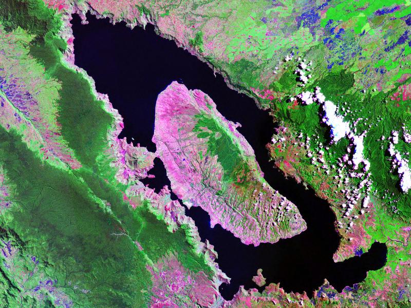
 Landsat image of Lake Toba
 Marapi
geo.wikisort.org - Mountains
The Bukit Barisan or the Barisan Mountains are a mountain range on the western side of Sumatra, Indonesia, covering nearly 1,700 km (1,050 mi) from the north to the south of the island. The Bukit Barisan range consists primarily of volcanoes shrouded in dense jungle cover, including Sumatran tropical pine forests on the higher slopes.[1] The highest peak of the range is Mount Kerinci at 3,800 metres (12,467 ft).[2] The Bukit Barisan Selatan National Park is situated towards the southern end of the range Liwa, Indonesia.
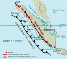
The name Bukit Barisan actually means "row of hills" or "hills that make a row" in Malay, for the range stretches end to end along the island of Sumatra.
There are 35 active volcanoes in Bukit Barisan. The largest volcano is the supervolcano Toba within the 100 km (62 miles) × 30 km (19 miles) Lake Toba, which was created after a caldera collapse (est. in 74,000 Before Present).[3] The eruption is estimated to have been at level eight on the VEI scale, the largest possible for a volcanic eruption.
List of volcanoes
The following list is sourced from the Smithsonian Institution's Global Volcanism Program.[4]
| Name | Shape | Elevation | Last eruption (VEI) | Geolocation |
|---|---|---|---|---|
| Weh | stratovolcano | 617 metres (2,024 ft) | Pleistocene | 5.82°N 95.28°E |
| Seulawah Agam | stratovolcano | 1,810 metres (5,940 ft) | 1839 (2) | 5.448°N 95.658°E |
| Peuet Sague | complex volcano | 2,801 metres (9,190 ft) | 25 December 2000 (2) | 4.914°N 96.329°E |
| Geureudong | stratovolcano | 2,885 metres (9,465 ft) | 1937 | 4.813°N 96.82°E |
| Mount Leuser | non-volcanic | 3,466 metres (11,371 ft) | 3°44′29″N 97°9′18″E | |
| Kembar | shield volcano | 2,245 metres (7,365 ft) | Pleistocene | 3.850°N 97.664°E |
| Sibayak | stratovolcano | 2,212 metres (7,257 ft) | 1881 | 3.23°N 98.52°E |
| Sinabung | stratovolcano | 2,460 metres (8,070 ft) | 2 March 2021[5] | 3.17°N 98.392°E |
| Toba | supervolcano | 2,157 metres (7,077 ft) | cca 75.000 years ago | 2.58°N 98.83°E |
| Helatoba-Tarutung | fumarole field | 1,100 metres (3,600 ft) | Pleistocene | 2.03°N 98.93°E |
| Imun | unknown | 1,505 metres (4,938 ft) | unknown | 2.158°N 98.93°E |
| Sibualbuali | stratovolcano | 1,819 metres (5,968 ft) | unknown | 1.556°N 99.255°E |
| Lubukraya | stratovolcano | 1,862 metres (6,109 ft) | unknown | 1.478°N 99.209°E |
| Sorikmarapi | stratovolcano | 2,145 metres (7,037 ft) | 1986 (1) | 0.686°N 99.539°E |
| Talakmau | complex volcano | 2,919 metres (9,577 ft) | unknown | 0.079°N 99.98°E |
| Sarik-Gajah | volcanic cone | unknown | unknown | 0.008°N 100.20°E |
| Marapi | complex volcano | 2,891 metres (9,485 ft) | 5 August 2004 (2) | 0.381°S 100.473°E |
| Tandikat | stratovolcano | 2,438 metres (7,999 ft) | 1924 (1) | 0.433°S 100.317°E |
| Talang | stratovolcano | 2,597 metres (8,520 ft) | 12 April 2005 (2) | 0.978°S 100.679°E |
| Kerinci | stratovolcano | 3,800 metres (12,500 ft) | 22 June 2004 (2) | 1.697°S 101.264°E |
| Hutapanjang | stratovolcano | 2,021 metres (6,631 ft) | unknown | 2.33°S 101.60°E |
| Sumbing | stratovolcano | 2,507 metres (8,225 ft) | 23 May 1921 (2) | 2.414°S 101.728°E |
| Kunyit | stratovolcano | 2,151 metres (7,057 ft) | unknown | 2.592°S 101.63°E |
| Pendan | unknown | unknown | unknown | 2.82°S 102.02°E |
| Belirang-Beriti | compound | 1,958 metres (6,424 ft) | unknown | 2.82°S 102.18°E |
| Bukit Daun | stratovolcano | 2,467 metres (8,094 ft) | unknown | 3.38°S 102.37°E |
| Kaba | stratovolcano | 1,952 metres (6,404 ft) | 22 August 2000 (1) | 3.52°S 102.62°E |
| Dempo | stratovolcano | 3,173 metres (10,410 ft) | October 1994 (1) | 4.03°S 103.13°E |
| Patah | unknown | 2,817 metres (9,242 ft) | unknown | 4.27°S 103.30°E |
| Bukit Lumut Balai | stratovolcano | 2,055 metres (6,742 ft) | unknown | 4.23°S 103.62°E |
| Besar | stratovolcano | 1,899 metres (6,230 ft) | April 1940 (1) | 4.43°S 103.67°E |
| Suoh | caldera | 1,000 metres (3,300 ft) | 10 July 1933 (4) | 5.25°S 104.27°E |
| Hulubelu | caldera | 1,040 metres (3,410 ft) | 1836 | 5.35°S 104.60°E |
| Rajabasa | stratovolcano | 1,281 metres (4,203 ft) | 1798 | 5.78°S 105.625°E |
Mountain is not active
The following list is sourced from the Study Archaeology[6][7][8]
| Name | Shape | Elevation | Last eruption (VEI) | Geolocation |
|---|---|---|---|---|
| Mount Pesagi | caldera | 3,262 metres (10,702 ft) | unknown | 1.167°S 101.325°E |
| Sekincau Belirang | caldera | 1,719 metres (5,640 ft) | unknown | 5.12°S 104.32°E |
| Ranau | caldera | 1,881 metres (6,171 ft) | unknown | 4.83°S 103.92°E |

See also
- List of volcanoes in Indonesia
- Kodam I/Bukit Barisan
References
Wikimedia Commons has media related to Bukit Barisan.
- Travelling in Indonesia Archived August 18, 2007, at the Wayback Machine
- "Kerinci". Global Volcanism Program. Smithsonian Institution.
- Oppenheimer, C. (2002). "Limited global change due to the largest known Quaternary eruption, Toba ≈74 kyr BP?". Quaternary Science Reviews. 21 (14–15): 1593–1609. doi:10.1016/S0277-3791(01)00154-8.
- "Volcanoes of Indonesia - Sumatra". Global Volcanism Program. Smithsonian Institution. Archived from the original on 30 December 2006. Retrieved 2006-11-17.
- "Global Volcanism Program | Sinabung". Smithsonian Institution | Global Volcanism Program. Retrieved 2022-11-01.
- https://sekalabrak.com/sebuah-kisah-usai-penobatan-sultan-sekala-brak-yang-dipertuan-ke-23/
- "Gunung Pesagi, Atapnya Lampung Indahnya Kebangetan - Gunung". 20 February 2020.
- "Volcanoes of Indonesia - Sumatra". Global Volcanism Program. Smithsonian Institution. Archived from the original on 30 December 2006. Retrieved 2006-11-17.
Authority control | |
|---|---|
| General | |
| National libraries | |
На других языках
[de] Barisangebirge
Das Barisan-Gebirge (indonesisch: Bukit Barisan) ist eine nahezu 1700 km lange Bergkette, die sich parallel der gesamten Westküste der Insel Sumatra, (Indonesien) erstreckt.- [en] Barisan Mountains
[es] Cordillera de Barisan
La cordillera de Barisan es una cadena montañosa de Indonesia que discurre por la parte occidental de la isla de Sumatra, con una longitud de casi 1700 km. Consiste principalmente de volcanes envueltos en espesa jungla.[1] El pico más alto de la cordillera es el monte Kerinci con 3805 metros.[2] El parque nacional de Bukit Barisan Selatan está situado hacia el extremo sur de la cordillera. El nombre Bukit Barisan en realidad significa "hilera de colinas" o "colinas que hacen una hilera" en indonesio y malayo, porque la cordillera se extiende de extremo a extremo a lo largo de la isla de Sumatra.[fr] Bukit Barisan
Les Bukit Barisan (« montagnes en rang » en malais) sont une chaîne volcanique qui s'étire sur quelque 1 700 kilomètres le long de la côte occidentale de l'île indonésienne de Sumatra. Elles consistent essentiellement en volcans couverts d'une dense jungle. Leur point culminant est le Kerinci à 3 805 mètres.[it] Bukit Barisan
I monti Bukit Barisan sono una catena montuosa lunga 1700 km situata lungo la costa occidentale di Sumatra, in Indonesia. La catena dei Bukit Barisan è costituita soprattutto da una serie di vulcani ricoperta da una fitta giungla[1]. La vetta più elevata della catena è il Monte Kerinci, con i suoi 3800 metri[2]. Nei pressi dell'estremità meridionale della catena è situato il Parco nazionale di Bukit Barisan Selatan.[ru] Барисан
Бариса́н[1] либо Бари́сан[2], также Буки́т-Барисан (индон. Bukit Barisan) — горный хребет на индонезийском острове Суматра. Длина хребта около 1700 км, он протянут практически по длине всего острова вдоль его западного побережья от Ачеха на севере до Лампунга на юге. В его составе десятки вулканов, из которых не менее 35 — действующие. Возраст хребта оценивается примерно в 70 млн лет. В основном покрыт джунглями.Текст в блоке "Читать" взят с сайта "Википедия" и доступен по лицензии Creative Commons Attribution-ShareAlike; в отдельных случаях могут действовать дополнительные условия.
Другой контент может иметь иную лицензию. Перед использованием материалов сайта WikiSort.org внимательно изучите правила лицензирования конкретных элементов наполнения сайта.
Другой контент может иметь иную лицензию. Перед использованием материалов сайта WikiSort.org внимательно изучите правила лицензирования конкретных элементов наполнения сайта.
2019-2026
WikiSort.org - проект по пересортировке и дополнению контента Википедии
WikiSort.org - проект по пересортировке и дополнению контента Википедии