geo.wikisort.org - Mountains
The Chin Hills[1] are a range of mountains in Chin State, northwestern Burma (Myanmar), that extends northward into India's Manipur state.[2]
| Chin Hills | |
|---|---|
 Chin Hills Location in Myanmar | |
| Highest point | |
| Peak | Nat Ma Taung |
| Elevation | 3,053 m (10,016 ft) |
| Coordinates | 22°30′N 93°30′E |
| Geography | |
| Location | Chin State, Burma |
| Parent range | Patkai Range |
Geography
The highest peak in the Chin Hills is Khonu Msung, or Mount Victoria, in southern Chin State, which reaches 3,053 metres (10,016 ft). The Chin Hills–Arakan Yoma montane forests ecoregion has diverse forests with pine, camellia and teak. Falam is the largest town in the Chin Hills, lying at their southern edge.
The Chin Hills are the eastern part of the Patkai Range, which includes the Lushai Hills and runs through Nagaland in India, as well as part of Burma. The Lushai Hills are frequently discussed with the Chin Hills as the topography, people's culture and history are similar. The southern prolongation of the Chin Hills is the Arakan Range (Arakan Yoma), stretching as well from north to south.
History
Historically the area of the range has been populated by the Chin people who like their neighbours to the west are a Laimi people. In addition to subsistence agriculture the Chin raided the villages of the Burman on the plains of the Myittha and Chindwin rivers, as well as each other.[3] In 1888, the British began a military campaign to end these raids which resulted in pacification of the province by 1896,[3] and it was administratively added to Burma as a special division.
In the Second World War the hills formed a point of armed conflict between Japanese forces and a combined British and Indian force.[4]
See also
- Arakan Mountains
- Chin Hills-Arakan Yoma montane forests
Notes
- "Chin Hills (Approved)" Chin Hills at GEOnet Names Server, United States National Geospatial-Intelligence Agency
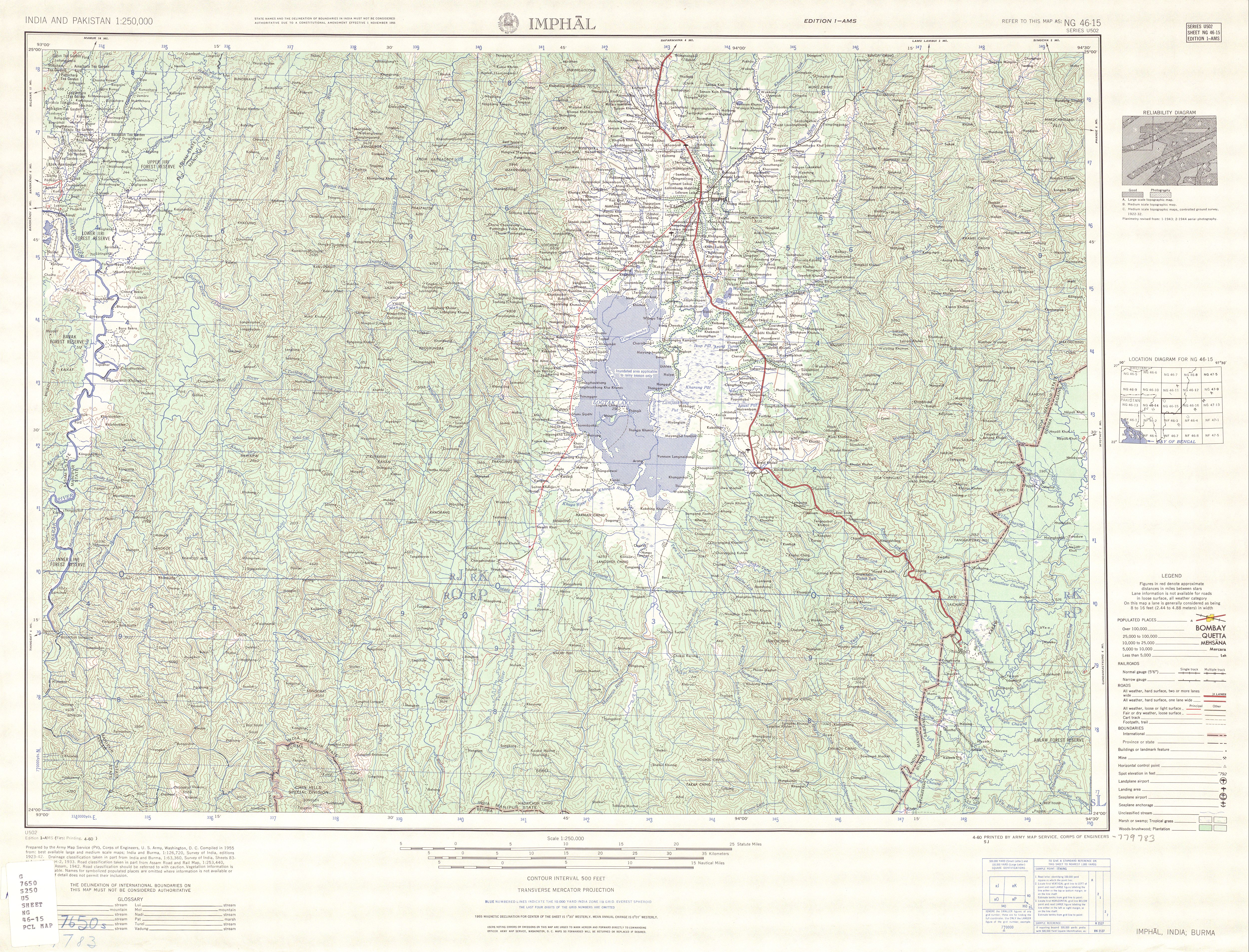
- "1:250,000 topographic map, Series U502, Imphal, India, NG 46-15" U.S. Army Map Service, April 1960; "1:250,000 topographic map, Series U542, Mawlaik, Burma; India, NF 46-3" U.S. Army Map Service, March 1960; and "1:250,000 topographic map, Series U542, Gangaw, Burma, NF 46-7" U.S. Army Map Service, April 1958
- Ireland, Alleyne (1907) The province of Burma: a report prepared on behalf of the University of Chicago Houghton-Mifflin, Boston, Massachusetts, volume 2, page 790, OCLC 1889867
- "Archived copy" (PDF). Archived from the original (PDF) on 4 August 2016. Retrieved 10 June 2016.
{{cite web}}: CS1 maint: archived copy as title (link)
External links
- Burma - Geography
- Google Books, The Physical Geography of Southeast Asia
- . Encyclopædia Britannica. Vol. 6 (11th ed.). 1911. p. 233.
This Chin State location article is a stub. You can help Wikipedia by expanding it. |
На других языках
- [en] Chin Hills
[fr] Chin Hills
Les Chin Hills sont un massif au sud-est de l'Himalaya qui fait office de frontière naturelle entre le nord-ouest de la Birmanie et l'est de l'Inde. Les Chin Hills sont en contact avec les Lushaï Hills. La région est peuplée principalement par le peuple Zo[it] Chin Hills
Le Chin Hills sono una catena montuosa situata nello stato Chin, nella Birmania nord-occidentale, che si protende verso nord fin nello stato indiano del Manipur[1].[ru] Чин (горы)
Чин[1] (Чин-Хилс[2]; бирм. ချင်းတောင်တန်း) — горы в штате Чин, на северо-западе Мьянмы, которые вдаются в индийский штат Манипур. Они являются частью хребта Ракхайн[источник не указан 2318 дней].Другой контент может иметь иную лицензию. Перед использованием материалов сайта WikiSort.org внимательно изучите правила лицензирования конкретных элементов наполнения сайта.
WikiSort.org - проект по пересортировке и дополнению контента Википедии