geo.wikisort.org - River
The Chindwin River (also called the Ningthi River)[1] is a river flowing entirely in Myanmar, and the largest tributary of the country's main river, the Ayeyarwady.[2] Its official name is also spelled Chindwinn.[3]
| Chindwin River | |
|---|---|
 The Chindwin at Homalin. The smaller, meandering Uyu River can be seen joining the Chindwin. | |
 | |
| Location | |
| Country | Myanmar |
| Physical characteristics | |
| Source | |
| • location | Hukawng Valley, Kachin State |
| • elevation | 1,134 m (3,720 ft) |
| Mouth | |
• location | Irrawaddy River |
• coordinates | 21°28′26″N 95°16′53″E |
• elevation | 55 m (180 ft) |
| Length | 1,207 km (750 mi) |
| Discharge | |
| • average | 4,700 m3/s (170,000 cu ft/s) |
Sources
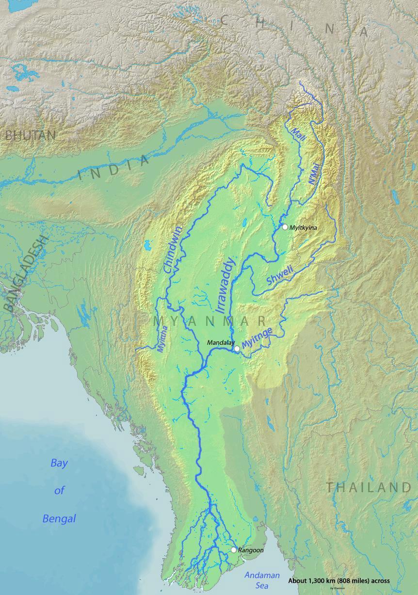
The Chindwin originates in the broad Hukawng Valley of Kachin State of Burma, roughly 26°26′18″N 96°33′32″E, where the Tanai, the Tabye, the Tawan, and the Taron (also known as Turong or Towang) rivers meet.
The headwaters of the Tanai are at about 25°30′N 97°0′E on the Shwedaunggyi peak of the Kumon range, 12 miles (19 km) north of Mogaung. It flows due north for the first part until it reaches the Hukawng Valley. In 2004, the government established the world's largest tiger preserve in the Hukawng Valley, the Hukaung Valley Wildlife Sanctuary, with an area of approximately 6,500 km2 (2,500 sq mi); later, the Sanctuary was extended to 21,800 square kilometres (8,400 sq mi), making it the largest protected area in mainland Southeast Asia. The river then turns to the west and flows through the middle of the plain,[2] joined by the Tabye, the Tawan, and the Taron rivers from the right bank. These rivers drain the mountain ranges to the north and northeast of the Hukawng valley.
Course
The Tanai exits the Hukawng valley through the Taron or Turong valley and through a sharp defile in the river. It then takes on the name of Chindwin, and maintains a general southerly course.[2] It passes the town of Singkaling Hkamti on the left bank, then the town of Homalin, also on the left bank.
The river's course is generally southwesterly until the town of Mingin. It then takes a more southeasterly course entering into broad central plain, passing the city of Monywa on the left bank. Its course at this point forms the boundary between the Sagaing District of Sagaing Region and the Pakokku District of Magway Region.
It enters the Ayeyarwady River (Irrawaddy) at about 21°30′N 95°15′E. The extreme outlets into the Ayeyarwady are about 22 miles (35 km) apart, the interval forming a succession of long, low, partially populated islands. The lowest mouth of the Chindwin is, according to tradition, an artificial channel, cut by one of the kings of Bagan (Pagan). It was choked up for centuries until 1824 when it was opened out by an exceptional flood.[4] Satellite pictures show this lowest channel to be the widest one today.[5]
Tributaries
- Uyu River is the largest tributary joining the Chindwin river just below Homalin on the left. The famous jade mines at Hpakant lie in the headwaters of the Uyu.[6][7]
- Myittha River, draining the Kale valley, joins on the right further downstream. The town of Kalewa is on the left bank of their confluence.
Towns


- Hkamti
- Htamanthi
- Homalin
- Mawlaik
- Kalewa
- Kalaymyo
- Mingin
- Monywa[8]
Environment
Much of Chindwin's course lies within mountain ranges and forests. Due to the difficulty of access, much of it remains unspoilt. The government of Burma recently created a very large (2,500 square mile) sanctuary for the endangered tiger within the Hukawng Valley.[9]
History
The mountain ranges to the west of the Chindwin are formidable, yet not totally impregnable to armies. The Kabaw valley saw many an invasion by the kingdom of Manipur to the west, most notably during the reign of King Garibaniwaj (1709–1748) when his army crossed over the Chindwin and the Mu, took Myedu, and reached as far as Sagaing opposite the capital Ava. The tables were turned in 1758 after King Alaungpaya ascended the Burmese throne.[10] The Burmese army invaded and occupied Manipur and Assam marching across the western mountain ranges, and even encroached upon British India.
During World War II, when the Japanese had cut off sea access, the British army and other allied forces under General Joseph Stilwell retreated on foot to India across the same mountains, with disastrous results, mainly due to disease and hunger. The Ledo Road was built across the Hukawng valley to supply China.[11] The Chindwin was a major barrier both for the Japanese trying to invade India and for the Allied forces to reoccupy Burma.[12]
Ethnography and culture
The chindwin river has a great impact on the culture of western Burma.[13] Central Sino-Tibetan (which includes Meithei) languages originated from valley areas of this river.
Economics
The Chindwin is served by regular river-going vessels up to the town of Homalin. Teak forests within its drainage area have been a valuable resource since ancient times. The Hukawng Valley is known for its abundance of Burmese amber. Along the river, there are deposits of jade, but Hpakant in the headwaters of the Uyu river is the only place in the world where the finest jade - known as jadeite or imperial jade - is found, along with an abundance of fish.[6][7]
Notes
- Pemberton, R. Boileau (1835). Report On The Eastern Frontier Of British India. Baptist Mission Press, Kolkata. pp. 19–20.; McCulloch, W.Maj (1859). Account of the Valley of Munnipore and of the Hill Tribes; with a Comparative Vocabulary of the Munnipore and other Languages. Bengal Printing Company Limited (Calcutta). pp. 8–40.; Siṃha, Kārāma Manimohana (1989), Hijam Irabot Singh and Political Movements in Manipur, B.R. Publishing Corporation, ISBN 978-81-7018-578-9
- Chisholm, Hugh, ed. (1911). . Encyclopædia Britannica. Vol. 6 (11th ed.). Cambridge University Press. p. 232.
- "Archived copy" (PDF). Archived from the original (PDF) on 2018-07-28. Retrieved 2018-08-08.
{{cite web}}: CS1 maint: archived copy as title (link) - "Chindwin River". Encyclopædia Britannica online. Retrieved 2008-10-07.
- "Earth from Space". NASA, November 1998. Archived from the original on 2007-08-02. Retrieved 2008-10-07.
- "Hpakan Other Rock Mine(Myanmar)". aditnow.co.uk. Retrieved 2008-12-27.
- Richard W. Hughes; Fred Ward. "Heaven and Hell: The Quest for Jade in Upper Burma". Ruby-Sapphire.com. Archived from the original on 2009-02-05. Retrieved 2008-12-27.
- "Map of Sagaing Division". Asterism. Retrieved 2008-10-07.
- "Rationale for a National Tiger Action Plan for Myanmar" (PDF). Wildlife Conservation Society (WCS). Archived from the original (PDF) on 2009-02-26. Retrieved 2008-12-27.
- Phanjoubam Tarapot (2003). Bleeding Manipur. Har-Anand Publications. pp. 112–3. ISBN 978-81-241-0902-1. Retrieved 2008-11-19.
- Baruah, Sri Surendra. "The Stillwell Road A Historical Review". Tinsukia. Archived from the original on 2008-10-13. Retrieved 2008-11-19.
- "Chindwin River". The Pacific War Online Encyclopaedia. Retrieved 2008-10-07.
- Andrew Hsiu which taken from a journal titled "Morphological Evidence for a Central Branch of Trans-Himalayan (Sino-Tibetan)." by Scott DeLancey which was published on 2015
Bibliography
- J. G. Scott, Gazetteer of Upper Burma and the Shan States. 5 vols. Rangoon, 1900–1901
External links
Authority control | |
|---|---|
| General |
|
| National libraries | |
На других языках
[de] Chindwin
Der Chindwin ist ein orografisch rechter Nebenfluss des Irawadi in Myanmar (Birma) und hat eine Länge von ca. 840 Kilometern.- [en] Chindwin River
[es] Río Chindwin
El Chindwin es un largo río asiático que discurre por Birmania (Myanmar), el más largo afluente del río Ayeyarwady. Todo su recorrido transcurre en Birmania y los manipuris lo conocen por el nombre de Ning-thi.[it] Chindwin
Il fiume Chindwin (in birmano Cindwin Myit) è un fiume della Birmania (Myanmar) e il maggior affluente del fiume Irrawaddy.[ru] Чиндуин
Чиндуи́н[1][2] (Чиндвин[3][2]) — река на западе Мьянмы. Крупнейший, правый, приток Иравади[1]. Длина около 1100 км, площадь бассейна около 114 000 км²[1].Другой контент может иметь иную лицензию. Перед использованием материалов сайта WikiSort.org внимательно изучите правила лицензирования конкретных элементов наполнения сайта.
WikiSort.org - проект по пересортировке и дополнению контента Википедии