geo.wikisort.org - Mountains
The Arakan Mountains (Burmese: ရခိုင်ရိုးမ), also known as the Rakhine Yoma, are a mountain range in western Myanmar, between the coast of Rakhine State and the Central Myanmar Basin, in which flows the Irrawaddy River. It is the most prominent of a series of parallel ridges that arc through Assam, Nagaland, Manipur, Mizoram and Myanmar.
| Arakan Mountains | |
|---|---|
| Rakhine Mountains | |
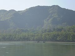
 View of the Arakan Mountains in Maungdaw district rising above the banks of the Naf River | |
| Highest point | |
| Peak | Mount Victoria |
| Elevation | 3,094 m (10,151 ft) |
| Coordinates | 21°25′46.36″N 93°49′10.75″E |
| Naming | |
| Native name | ရခိုင်ရိုးမ (Burmese) |
| Geography | |
| Country | Myanmar |
| State | Rakhine State |
| Range coordinates | 21°16′N 93°57′E |
| Geology | |
| Type of rock | metamorphic and tightly folded sedimentary rocks over crystalline basement |
The Arakan Mountains run from Cape Negrais in the south in to Manipur, India in the north. They include the Naga Hills, the Chin Hills, and the Patkai range which includes the Lushai Hills.[1] The mountain chain is submerged in the Bay of Bengal for a long stretch and emerges again in the form of the Andaman and Nicobar Islands.
Etymology
The word Arakan is derived from the Sanskrit word Rakshasa (राक्षस), a term used to refer to the inhabitants of the region.[2]
Geology and formation
The Arakan Mountains and the parallel arcs to the west and east were formed by compression as the Indian Plate collided with the Eurasian Plate approximately along the boundary between India and Myanmar which produced the Naga-Patkai foldbelt.[3][4]
High points
The Arakan Mountain Range is over 600 miles (950 km) long,[1] with about 250 miles (400 km) of actual mountains. The highest point in the range is Khonu Msung (or Mount Victoria) at 3,094 metres (10,151 ft).
Infrastructure
The Arakan Mountains are crossed by a road between Ngape and Minbu and by an all-weather road from Taungup to Pyay on the Irrawaddy.
History
The Arakan Mountains divide the Rakhine coast from the rest of Myanmar, and thus have acted as a barrier between the peoples of central Myanmar and those of the Indian subcontinent. This played a role in fostering the separate development of the Rakhine people, both linguistically and culturally, from the Burmese. The Arakan Mountains also served as a barrier inhibiting Burmese invasions, and allowing Arakan to develop as a separate political entity. Thus the coastal cities, such as Mrauk U and Waithali, formed the core of Arakan civilization.
There were fierce battles in these mountains between January 1943 and March 1944 during the Japanese occupation of Burma. The Japanese 33rd and 55th Divisions faced the British military on the coastal side of the range. The British forces won.
Ecology
The Arakan Mountains act as a barrier to the southwestern monsoon rains and thus shield the central Myanmar area, making their western slopes extraordinarily wet during the monsoon with typically over 1 metre (39 in) of rain per month, and the eastern slopes much drier.[1] They include the Chin Hills-Arakan Yoma montane forests ecoregion which is home to an elephant population and also the critically endangered Arakan forest turtle which was considered extinct until its rediscovery in 1994.[5]
Notes
- "Rakhine Mountains". Encyclopædia Britannica. Retrieved 9 Nov 2013.
- The Indian Magazine and Review, Issues 265-276. National Indian Association in Aid of Social Progress and Education in India. 1893. p. 403.
- See Geology of India#Plate tectonics for more detail.
- Akhtar, Mohammad S. et al. (2010) "Structural Style and Deformation History of Assam & Assam Arakan Basin, India: from Integrated Seismic Study" (adapted from oral presentation at AAPG Annual Convention, Denver, Colorado, June 7–10, 2009)
- Platt, K.; Rahman, S.; Horne, B.D.; Praschag, P. (2020). "Heosemys depressa". IUCN Red List of Threatened Species. 2020: e.T39596A2929864. doi:10.2305/IUCN.UK.2020-2.RLTS.T39596A2929864.en. Retrieved 26 October 2022. Listed as Critically Endangered (CR A2cd+4cd v3.1)
External links
На других языках
[de] Arakan-Joma-Gebirge
Das Arakan-Joma-Gebirge (auch Arakan-Yoma oder Chin-Gebirge) ist ein Gebirgszug an der Grenze zwischen Indien und Myanmar (Birma) und bildet einen der südöstlichen Ausläufer des Himalaya.- [en] Arakan Mountains
[es] Cordillera Arakan
La cordillera Arakan es una cadena de montañas que se extienden al norte de Asia, concretamente en Birmania. También es conocida como la cordillera Arakan Yoma. El pico más alto es Nat Ma Taung (Monte Victoria) que alcanza los 3.053 m, la montaña más alta con un pico a base de tierra y la única situada en el sur del estado de Chin, limitando con las localidades de Mindat y Kanpatlat. Es también conocida como una reserva para aves y animales salvajes y un bosque natural. La cordillera forma parte de la ecorregión bosques de montaña Chin Hills-Arakan Yoma, con diversos bosques que incluyen pino y teca. Cada año universidades de Birmania de la Asociación de Excursionismo y Montañismo practican senderismo.[1] Más de 50 grupos étnicos que usan idiomas diferentes viven en la cordillera Arakan. La cordillera Arakan está poblada por el pueblo zo.[fr] Chaîne de l'Arakan
La chaîne de l'Arakan, en birman Arakan Yoma, est un arc montagneux de l'ouest de la Birmanie et l'est de l'Inde.[it] Monti Arakan
I monti Arakan (noti anche come Arakan-Yoma o monti Chin) sono una catena montuosa situata lungo il confine tra India e Birmania (Myanmar); costituiscono uno dei contrafforti sud-orientali dell'Himalaya.[ru] Ракхайн (хребет)
Ракха́йн[1][2][3], Арака́н[4], Аракан-Йома[3][5] или Араканские горы[3][6][7](бирм. ရခိုင်ရိုးမ) — горный хребет в западной Мьянме, между побережьем штата Ракхайн и Центральной Мьянмой, где протекает река Иравади. Его образует серия параллельных гряд, которые проходят дугой Мьянму. Хребет Ракхайн протянулся от мыса Модин (Пагода) на юге до штата Манипур на севере. Он включает горы Нага[en], Чин и Пакайн (Паткай)[en], который, в свою очередь, включает Лушаи[en][8]Другой контент может иметь иную лицензию. Перед использованием материалов сайта WikiSort.org внимательно изучите правила лицензирования конкретных элементов наполнения сайта.
WikiSort.org - проект по пересортировке и дополнению контента Википедии
