geo.wikisort.org - Mountains
The Pontic Mountains or Pontic Alps (Turkish: Kuzey Anadolu Dağları, meaning North Anatolian Mountains) form a mountain range in northern Anatolia, Turkey. They are also known as the Parhar Mountains in the local Turkish and Pontic Greek languages. The term Parhar originates from a Hittite word meaning "high" or "summit".[1] In ancient Greek, the mountains were called the Paryadres[2] or Parihedri Mountains.[3]
| Pontic Mountains | |
|---|---|
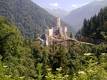
 Sumela Monastery on the Pontic Mountains | |
| Highest point | |
| Peak | Mt. Kaçkar |
| Elevation | 3,937 m (12,917 ft) |
| Coordinates | 40°50′N 41°09′E |
| Dimensions | |
| Length | 1,000 km (620 mi) |
| Geography | |
| Countries | Turkey and Georgia |
| Range coordinates | 40°30′N 40°30′E |
Geography

The range runs roughly east–west, parallel and close to the southern coast of the Black Sea. It extends northeast into Georgia, and west into the Sea of Marmara, with the northwestern spur of the Küre Mountains (and their western extension the Akçakoca Mountains) and the Bolu Mountains, following the coast. The highest peak in the range is Kaçkar Dağı, which rises to 3,937 m (12,917 ft). The North Anatolian Fault and the Northeast Anatolian Fault, which are east–west-running strike-slip faults, run along the length of the range.
Ecology
The mountains are generally covered by dense forests, predominantly of conifers.
The Northern Anatolian conifer and deciduous forests is an ecoregion which covers most of the range, while the Caucasus mixed forests extend across the far-eastern end of the range, known as the Kaçkar Mountains. The narrow coastal strip between the mountains and the Black Sea, known as Pontus, is home to the Euxine-Colchic deciduous forests, which contain some of the world's few temperate rainforests.
The region is home to Eurasian wildlife such as the Eurasian sparrowhawk, golden eagle, eastern imperial eagle, lesser spotted eagle, Caucasian black grouse, red-fronted serin, and wallcreeper.[4]
Winter conditions are very harsh, and snow even in summer months isn't unusual above certain elevations.[5]
The Anatolian Plateau, which lies south of the range, has a considerably drier and more continental climate than the humid and mild coast, owing to the mountains' rain shadow effect.[6]
References
- Karadeniz Ansiklopedik Sözlük Archived 2008-05-13 at the Wayback Machine. See the "Parhar" (plateau) and "Parhal" (village) articles.
- Strabo. "Chapter XI". Geographica (35 BC – 23 AD). p. xii.4.
- Pliny the Elder. "Chapter VI". Naturalis Historia (77–79 AD). p. iix.25.
- Couzens, Dominic (2008). Top 100 Birding Sites of the World. University of California Press. pp. 73–75. ISBN 978-0-520-25932-4.
- "File:Koppen-Geiger Map TUR present.svg". commons.wikimedia.org. 6 November 2018. Retrieved 2021-03-14.
- Pontic Mountains and highlands Archived 2014-02-26 at the Wayback Machine
| Mountain ranges | |
|---|---|
| Mountains |
|
| Authority control |
|
|---|
This article about a Black Sea Region of Turkey location is a stub. You can help Wikipedia by expanding it. |
На других языках
[de] Pontisches Gebirge
Als Pontisches Gebirge oder Pontische Alpen (türkisch Kaçkar Dağları, auch Pontusgebirge bzw. Nordanatolisches Randgebirge) wird eine Reihe von Gebirgsketten im Norden der Türkei bezeichnet, die sich etwa 1000 km entlang der Schwarzmeerküste von Kleinasien erstrecken. Sie gehören zur erdgeschichtlich relativ jungen alpidischen Gebirgsfaltung, die von den Pyrenäen und Alpen bis zum Himalaya verläuft, und erreichen Gipfelhöhen bis 3932 Meter. Der Name leitet sich vom altgriechischen Namen Pontos für die Landschaft an der Küste des Schwarzen Meeres (Pontos Euxinos) her, der auch auf die römische und später byzantinische Provinz Pontus überging, die bis 1143 existierte.- [en] Pontic Mountains
[es] Montes Pónticos
Los montes Pónticos o Alpes Pónticos (en turco, Doğu Karadeniz Dağları)[1] son una cordillera localizada en el norte de Turquía, cuyo extremo oriental se extiende por el sureste de Georgia.[fr] Chaîne pontique
La chaîne pontique (en géorgien : პონტოს მთები ; en turc Kuzey Anadolu Dağlari ou Karadeniz Dağlari), aussi appelée Alpes pontiques, est un massif montagneux situé dans le nord de la Turquie (il tire son nom de la région du Pont), et dont l'extrémité orientale atteint le sud-ouest de la Géorgie. La chaîne s'étire approximativement d'ouest en est sur 500 km, surplombant la côte méridionale de la mer Noire. Son sommet le plus élevé est le Kaçkar Dağı (le mont Cauron de l'Antiquité) qui s'élève à 3 942 m. La faille nord-anatolienne et la faille anatolienne du nord-est courent le long de la chaîne.[it] Monti del Ponto
I Monti del Ponto sono una catena montuosa nella Turchia settentrionale, la cui fine si estende nella Georgia sud-occidentale. La catena scorre principalmente da est verso ovest, parallela e vicina alla costa meridionale del Mar Nero. Il punto più alto della catena è il Kaçkar Dağı, che giunge a 3942 metri di altezza.[ru] Понтийские горы
Понти́йские го́ры известны также как Понти́йский хребе́т и Се́веро-Анатоли́йские го́ры (тур. Kuzey Anadolu Dağları), (арм. Պոնտական լեռներ) — горная система на севере Турции, протягивающаяся по южному берегу Чёрного моря, от устьев реки Ешильырмак до устьев реки Чорох и даже несколько далее до вершины Карчал (3428 метров), которая может считаться восточной его оконечностью. Площадь — 124 281 км².Другой контент может иметь иную лицензию. Перед использованием материалов сайта WikiSort.org внимательно изучите правила лицензирования конкретных элементов наполнения сайта.
WikiSort.org - проект по пересортировке и дополнению контента Википедии