geo.wikisort.org - Mountains
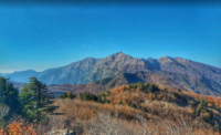
Mount Tmolus (Ancient Greek: Τμῶλος, modern Bozdağ; highest point: 2,157 m), named after Tmolus, King of Lydia, is in "a mountain range on the south of Sardis, forming the watershed between the basins of the Hermus in the north and the Cayster in the south, and being connected in the east with Mount Messogis."[1] It is situated in Lydia in western Turkey with the ancient Lydian capital Sardis at its foot and Hypaepa on its southern slope. The mountain was "celebrated for its excellent wine-growing slopes. It was equally rich in metals; and the river Pactolus, which had its source in Mount Tmolus, at one time carried from its interior a rich supply of gold."[1] The geography of Tmolus and the contest between Pan and Apollo, associated with the mythical Tmolus, son of Ares, are mentioned in Ovid's Metamorphoses, 11.168.
References
- Smith, William, ed. (1857). Dictionary of Greek and Roman Geography. London: Walton And Maberly, Upper Gower Street, and Ivy Lane, Paternoster Row; John Murray, Albemarle Street. p. 1214. ark:/13960/t2m61gk94.
На других языках
- [en] Mount Tmolus
[fr] Mont Tmole
Le mont Tmole (en grec : Τμώλος ; en latin : Tmolus) Tmolos, Tmolus ou Timolus[2] est une montagne de Lydie, dans l'Ouest de la Turquie, à la limite des provinces turques actuelles de Manisa et d'İzmir, séparant les bassins des fleuves Küçük Menderes (Caÿstre) au sud et Gediz (Hermos) au nord.[ru] Боздаглар
Боздаглар[1] — горный хребет в Малой Азии, в турецких илах Айдын, Маниса и Измир. Тянется от полуострова Чешме на восток, параллельно хребту Айдын (Месогида), с которым соединяется на востоке. Отделяет водораздел между бассейнами рек Гедиз (Герм) на севере и Малый Мендерес (Каистр) на юге. На склонах хребта берёт исток река Пактол (Сарт), левый приток Гедиза[4]. Высочайшая вершина — гора Боздаг (Bozdağ — «Серая гора»[5]) высотой 2156 м над уровнем моря[3][6], которая является 3-й по высоте в Эгейском регионе, уступая горам Хоназ (2571 м[7]) и Мурат[tr] (2312 м)[1]. У вершины, к северу от города Одемиш[en] и южнее Салихли находится деревня Боздаг[tr][1][2][8].Другой контент может иметь иную лицензию. Перед использованием материалов сайта WikiSort.org внимательно изучите правила лицензирования конкретных элементов наполнения сайта.
WikiSort.org - проект по пересортировке и дополнению контента Википедии