geo.wikisort.org - Mountains
The Cantabrian Mountains or Cantabrian Range (Spanish: Cordillera Cantábrica) are one of the main systems of mountain ranges in Spain. They stretch for over 300 km (180 miles) across northern Spain, from the western limit of the Pyrenees to the Galician Massif in Galicia, along the coast of the Cantabrian Sea. Their easternmost end meets the Sistema Ibérico.
| Cantabrian Mountains | |
|---|---|
| Spanish: Cordillera Cantábrica | |
 Cantabrian Mountains parallel to the Cantabrian Sea seen from Castro Valnera in an east-west direction. In the background, the Montaña Palentina (left) and the Picos de Europa (right) | |
| Highest point | |
| Peak | Torre de Cerredo |
| Elevation | 2,648 m (8,688 ft) |
| Coordinates | 43°11′51″N 04°51′06″W |
| Dimensions | |
| Length | 300 km (190 mi) WE |
| Width | 50 km (31 mi) NS |
| Naming | |
| Etymology | Named after the Cantabri |
| Geography | |
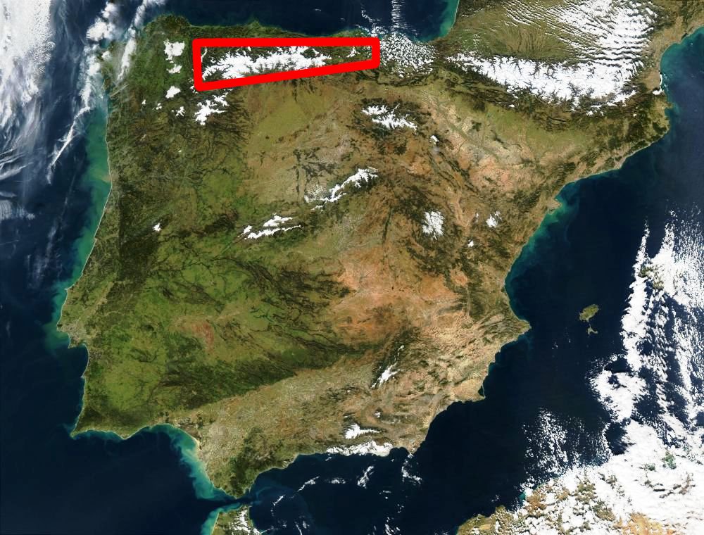 Location of the Cantabrian Mountains in northern Spain
| |
| Country | Spain |
| Communities | Basque Country, Castile and León, Cantabria and Asturias |
| Range coordinates | 43°N 5°W |
| Borders on | Pyrenees and Galicia |
| Geology | |
| Age of rock | Carboniferous, Paleozoic, Mesozoic |
| Type of rock | Limestone |


These mountains are a distinct physiographic province of the larger Alpine System physiographic division.
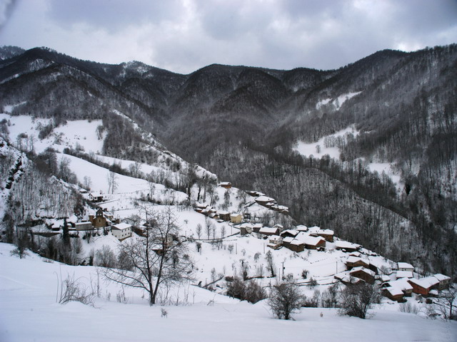
The Cantabrian Mountains offer a wide range of trails for hiking, as well as many challenging climbing routes. Skiing is possible in the ski resorts of Alto Campoo, Valgrande-Pajares, Fuentes de Invierno, San Isidro, Leitariegos and Manzaneda.
Geography
The Cantabrian Mountains stretch east-west, nearly parallel to the Cantabrian Sea, as far as the pass of Leitariegos, also extending south between León and Galicia. The range's western boundary is marked by the valley of the river Minho (Spanish: Miño), by the lower Sil, which flows into the Miño, and by the Cabrera River, a small tributary of the Sil.[1] The Cantabrian Mountains reach their south-western limit in Portugal.
As a whole, the Cantabrian Mountains are remarkable for their intricate ramifications, but almost everywhere, and especially in the east, it is possible to distinguish two principal ranges, from which the lesser ridges and mountain masses radiate. One range, or series of ranges, closely follows the outline of the coast; the other, which is loftier, forms the northern limit of the great tableland of Castile and León, and is sometimes regarded as a continuation of the Pyrenees. In some parts the coastal range rises sheer above the sea, and everywhere has so abrupt a declivity that the streams which flow seaward are all short and swift.[1]
The descent from the southern range to the high plateaux of Castile is more gradual, and several large rivers, notably the Ebro, rise here and flow to the south or west. The breadth of the Cantabrian chain, with all its ramifications, increases from about 60 mi (97 km); in the east to about 115 miles (185 km) in the west. Many peaks are over 6,000 feet (1,800 m) high, but the greatest altitudes are attained in the central ridges on the borders of León, Asturias, Palencia and Cantabria. Here are the highest peak Torre de Cerredo (8,688 feet (2,648 m))[contradictory], Peña Vieja (8,579 feet (2,615 m)), Peña Prieta (8,304 feet (2,531 m)) and Espigüete (7,898 feet (2,407 m)); an unnamed summit in the Picos de Europa, to which range the Peña Vieja also belongs, rises on the right bank of the Sella to a height of 8,045 feet (2,452 m); further west the peaks of Manpodres, Peña Ubiña, Peña Rubia and Cuiña all exceed 7,000 feet (2,100 m). A conspicuous feature of the chain, as of the adjacent tableland, is the number of its parameras, isolated plateaus shut in by lofty mountains or even by precipitous walls of rock.[2]
The Cantabrian Mountains make a sharp divide between "Green Spain" to the north, and the dry central plateau. The north facing slopes receive heavy cyclonic rainfall from the Cantabrian Sea, whereas the southern slopes are in rain shadow.
Main ranges
The Cantabrian Range has three very distinct sections from west to east:[according to whom?]
Western
The Asturian Massif and its foothills. Geologically it is an eastern prolongation of the Galician Massif with Paleozoic folds. It is cut by deep east-west oriented canyons such as the Cares River valley. Highest point Torre de Cerredo 2,648 m.[3]
- Sierra de la Bobia, Pico de la Bobia 1,201 m
- Sierra de Tineo, Mulleiroso 1,241 m, a northern foothill located near Tineo
- Sierra de San Isidro, Campo de La Vaga 1,078 m
- Sierra de Eirelo, Pena dos Ladróis 800 m
- Sierra del Sueve, Picu Pienzu 1,161 m, a northern foothill west of the Sella River
- Sierra de Cuera, Pico Turbina 1,315 m, anorthern foothill located at the eastern end of Asturias
- Sierra de Quintanal, running transversally on the eastern side of the Narcea River
- Other ranges of the Asturian Massif are: Sierra del Aramo, Sierra de Pando, Sierra de Caniellas, Sierra de Rañadoiro, Loma de Parrondo, Sierra de San Mamés, Sierra de Serrantina, Sierra de la Zarza, Sierra de Degaña, Sierra del Acebo, Sierra de Sobia, Cordal de Lena, Sierra de Casomera, Porrones de Moneo, and Cordal de Ponga
Central
The main mountains of this zone are the massive Picos de Europa. They are composed of Carboniferous limestone and marl.[4] The Paramo de Masa and La Lora grasslands are located in the south crossed by the Rudrón Valley.[5]
- Sierra de Covadonga, west of the Picos de Europa
- Sierra de Dobros, north of the Picos de Europa
- The Picos de Europa are divided into three sectors or massifs:
- Cornión Massif in the west, Torre Santa 2,596 m
- Urrieles Massif in the center, Torrecerredo 2,650 m
- Ándara Massif in the east, Morra de Lechugales 2,444 m
- Sierra de Liencres, a coastal range, another northern foothill
- Sierra Nedrina[6]
- Mountain ranges in Cantabria, located further east:
- Fuentes Carrionas Massif, Peña Prieta 2,536 m, close to the eastern end of the Picos de Europa
- Sierra Cocón above Tresviso
- Sierra del Escudo de Cabuérniga, a northern foothill of the system, located between the main ridges and the sea[7]
- Sierra de la Gándara, Peña Cabarga 537 m, a lower northern foothill located further east
- Montes de Ucieda
- Alto del Gueto
- Sierra de la Matanza
- Sierra de Peña Sagra, Peña Sagra 2,046 m
- Sierra de Peña Labra, Pico Tres Mares 2,175 m and Peña Labra 2,006 m
- Sierra del Cordel in the Saja and Nansa Comarca
- Sierra del Escudo, between Campoo de Yuso and Luena
- Sierra de Híjar, foothills located in the high plateau at the southeastern end of the central zone
- Valdecebollas
- Sierra del Hornijo, Mortillano 1,410
- Sierra de Breñas, foothill running perpendicular to the coast
- Montes de Pas, Castro Valnera 1,707 m in the transition area to the Basque Mountains


Eastern

The Basque Mountains at the eastern end of the system, with very eroded Mesozoic folds and ranges of moderate height:
- Inner ranges:
- Coastal ranges:
Flora and fauna
This section does not cite any sources. (December 2020) |

The Cantabrian Mountains are home to an important variety of plant life, as well as the Cantabrian brown bear (Ursus arctos pyrenaicus), catalogued as being in danger of extinction, which extends from Asturias (the region where its population is bigger) to areas in Léon, Palencia and Cantabria, and the Cantabrian capercaillie (T. urogallus cantabricus).
Other animals associated with the range include the Iberian wolf (Canis lupus signatus) and the rebeco, or Cantabrian chamois (Rupicapra pyrenaica parva).
Woodland in the Cantabrian Mountains is generally predominated by beeches (Fagus sylvatica).
Protected areas
The Cantabrian mountain range includes several protected areas such as the Picos de Europa National Park, which is one of several Cantabrian parks included in UNESCO's World Network of Biosphere Reserves. Some of the sites are included in the European Union's Natura 2000 network and Special Protection Areas for the Conservation of Wild Birds.
- Picos de Europa National Park
- Muniellos Nature Reserve
- Fuentes del Narcea, Degaña e Ibias Natural Park
- Redes Natural Park
- Somiedo Natural Park
- Protected Landscape Area of Sierra del Sueve
- Fuentes Carrionas and Fuente Cobre-Montaña Palentina Natural Park
- Saja-Besaya Natural Park
- Collados del Asón Natural Park
- Ojo Guareña
References
- Chisholm 1911, p. 207.
- Chisholm 1911, pp. 207–208.
- La Cordillera Cantábrica
- Geología de Cantabria Archived 2014-07-14 at the Wayback Machine
- J. Muñoz Jiménez, Geografía de Asturias. 1 . Geografía física. El relieve, el clima y las aguas. 1982
- Naturaleza en Asturias[permanent dead link]
- Estudio de caudales ecológicos en la red hidrográfica de Cantabria Archived 2013-06-26 at the Wayback Machine
Sources
- This article incorporates text from a publication now in the public domain: Chisholm, Hugh, ed. (1911). "Cantabrian Mountains". Encyclopædia Britannica. Vol. 5 (11th ed.). Cambridge University Press. pp. 207–208.
External links
 Media related to Cordillera Cantábrica at Wikimedia Commons
- iberianature.com - English-language web site on nature in Spain and Portugal
- Cantabrian Institute of Biodiversity
- Parque Natural de Las Ubiñas-La Mesa - Reserva de la Biosfera (I)
Geography topics | |||||||
|---|---|---|---|---|---|---|---|
| |||||||
| Branches |
| ||||||
| Techniques and tools |
| ||||||
| Institutions |
| ||||||
| Education |
| ||||||
| |||||||
Physical geography | ||
|---|---|---|
|  | |
| ||
Mountain ranges of Spain | ||
|---|---|---|
| ||
Authority control | |
|---|---|
| General | |
| National libraries | |
На других языках
[de] Kantabrisches Gebirge
Das Kantabrische Gebirge (spanisch Cordillera Cantábrica oder Sistema Cantábrico) ist ein Gebirgszug in Nordspanien. Es stellt die westliche Verlängerung der Pyrenäen dar und verläuft über 480 km durch die autonomen Regionen Navarra, Baskenland, Kantabrien, Kastilien-León, Asturien bis nach Galicien.- [en] Cantabrian Mountains
[fr] Cordillère Cantabrique
La cordillère Cantabrique ou monts Cantabriques est un système montagneux du Nord de l’Espagne.[it] Cordigliera Cantabrica
La Cordigliera Cantabrica (in spagnolo Cordillera Cantábrica), oppure Monti Cantabrici, è una catena montuosa del nord della Spagna, che si estende per 480 chilometri in direzione est-ovest, parallela al Mar Cantabrico.[ru] Кантабрийские горы
Кантабри́йские го́ры (исп. Cordillera Cantábrica, астур. Cordelera Cantábrica) — горная система на севере Пиренейского полуострова, простирающийся вдоль Бискайского залива на 500 км от западного края Пиренеев (Страна Басков) до границы Галисии. Хребет проходит по территории испанских провинций Кантабрия, Астурия и Кастилия-Леон. Высшая точка — гора Торре-де-Серредо (2648 м).Другой контент может иметь иную лицензию. Перед использованием материалов сайта WikiSort.org внимательно изучите правила лицензирования конкретных элементов наполнения сайта.
WikiSort.org - проект по пересортировке и дополнению контента Википедии