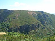
 Fold formation in Campodola-Leixazos, Serra do Courel, Lugo Province
 Pico Sacro near Boqueixón
 Mountain peaks near Verín
 View of Serra do Faro
geo.wikisort.org - Mountains
The Galician Massif (Spanish: Macizo Galaico, also known as Macizo Galaico-Leonés) is a system of mountain ranges in the northwestern corner of the Iberian Peninsula. It is located in Galicia with its southeastern end reaching into the provinces of Zamora and León of Castile and León. Its highest point is Pena Trevinca at 2,127 metres (6,978 ft) . Another important peak is Cabeza de Manzaneda (1,781 m).
| Galician Massif | |
|---|---|
| Macizo Galaico Macizo Galaico-Leonés | |
 | |
| Highest point | |
| Peak | Peña Trevinca |
| Elevation | 2,124 m (6,969 ft) |
| Coordinates | 42°14′33″N 6°47′45″W |
| Geography | |
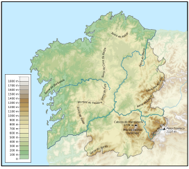 Topographic map of Galicia
| |
| Country | Spain |
| Autonomous Communities | Galicia and Castile and León |
| Range coordinates | 42°30′N 8°6′W |
| Geology | |
| Orogeny | Variscan orogeny |
| Age of rock | Paleozoic |
| Type of rock | Schist, gneiss and granite |
In traditional local folklore the forests of the Galician System are said to be inhabited by a variety of elves, fairies, ghosts, the Santa Compaña, the Nubeiro and witches (meigas).
Geology
Geomorphologically the Galician Massif is a northwestern prolongation of the Meseta Central, the inner Iberian plateau and has great affinity with the geology of the Tras os Montes Portuguese region, so that it is considered as a whole under the name 'Galicia-Trás-os-Montes Zone'.[1] It is composed of Paleozoic materials (granite) with metamorphic rocks such as gneiss, slate and schist in the center and west, which were subject to Alpine folding. Its eastern end merges with the Cantabrian Mountains.[2]
The relief of the system, with an average height of 500 metres (1,600 ft), is relatively smooth compared with other Iberian ranges. It is however very complex, having no defined structural alignment owing to the heavy fluvial erosion that has fragmented the terrain.
Generally the system includes mountains that are rounded in shape, often topped by small rocky outcrops, as well as horsts, basins and faults, roughly aligned in a N-S direction.
Vegetation
Since rain is abundant in Galicia, the undisturbed areas of the massif have a soft soil texture and are covered in dense vegetation of temperate deciduous forest where Quercus petraea and Quercus robur oaks predominate. The woods alternate with shrubland and wide natural meadows.[3]
The vegetation is quite homogeneous throughout the massif[4] and there is great plant biodiversity in the Galician mountains. Many of the species found in the mountains were used in Galician traditional medicine.[5]
The Serra dos Ancares was declared a UNESCO Biosphere Reserve in 2006.[6]
Mountain ranges
From the southeast to the northwest the Galician Massif has three physiographic longitudinal sections:
- The southwestern ranges; the highest elevations are found in this sector, including 2,047 m high Pena Trevinca, the highest point of the whole system. These ranges reach into the provinces of León and Zamora, hence the alternative name Macizo Galaico-Leonés, and show scars of the glacial period, which are apparent in the Serra do Eixe, also known as Serra da Segundera (Spanish: Sierra Segundera). Rivers Tera, Cabreira and Bibei run through glacial valleys and the San Martín de Castañeda Lake, Laguna de Lacillo lakes are moraine-dammed lakes.
- The Galician Dorsal Range; with 1,778 m high Cabeza de Manzaneda, its highest elevation. A tectonic basin running in a north-south direction separates it from the southwestern ranges. It includes the Central Ourensan Massif.
- The coastal ranges; such as Serra da Barbanza, are generally of a much lesser height and are separated from the Galician Dorsal Range by the Tui-Verín-Vigo intermontane basin.
List of ranges

- Serra de Meira
- Serra de Xistral
- Serra da Barbanza
- Serra da Cova da Serpe
- Serra do Faro
- Testeiro Range
- Galiñeiro Range
- Serra do Courel
- Serra dos Ancares
- Central Ourensan Massif
- Serra do Suído
- Serra do Eixe
- Serra do Xurés
Main ranges and features


See also
- Cantabrian Mountains
- Geography of Galicia
- Geography of Spain
- Geology of the Iberian Peninsula
References
- Silurian graptolite biostratigraphy of the Galicia - Tras-os-Montes Zone (Spain and Portugal)
- Wes Gibbons & Teresa Moreno, The geology of Spain. Geological Society of London, 2003
- CSIC List of Iberian flora Quercus sp. (in Spanish)
- Assessing the impact of wind farms on the plant diversity of blanket bogs in the Xistral Mountains (NW Spain)[permanent dead link]
- Medicinal Use of Some Plants in Galicia (NW Spain)
- Os Ancares UNESCO-MAB Biosphere Reserve
External links
 Media related to Macizo Galaico-Leonés at Wikimedia Commons
- Macizo Galaico (Chain) - Hiking Geographic Card Archived 2014-07-14 at the Wayback Machine
- Physical geography and geology of Spain
- Virtual Cadastral
Mountain ranges of Spain | ||
|---|---|---|
| ||
На других языках
- [en] Galician Massif
[es] Macizo Galaico-Leonés
El macizo Galaico-Leonés es un sistema de sierras y montañas españolas situadas en el extremo noroccidental de la península ibérica, cuyos límites orientales se confunden con la cordillera Cantábrica. Es un macizo montañoso «reciente», del Cenozoico, en el que afloran antiguas rocas del Paleozoico. Administrativamente, el macizo se ubica mayoritariamente en Galicia, aunque trasciende los límites de esta autonomía, ya que sus estribaciones ocupan también el sector más occidental de las provincias de Zamora y León.[fr] Massif galicien
Le Massif galicien est un massif montagneux du Nord-Ouest de l'Espagne, dans les communautés autonomes de la Galice et de Castille-et-León. Il culmine à la Peña Trevinca, à 2 127 m d'altitude.Текст в блоке "Читать" взят с сайта "Википедия" и доступен по лицензии Creative Commons Attribution-ShareAlike; в отдельных случаях могут действовать дополнительные условия.
Другой контент может иметь иную лицензию. Перед использованием материалов сайта WikiSort.org внимательно изучите правила лицензирования конкретных элементов наполнения сайта.
Другой контент может иметь иную лицензию. Перед использованием материалов сайта WikiSort.org внимательно изучите правила лицензирования конкретных элементов наполнения сайта.
2019-2026
WikiSort.org - проект по пересортировке и дополнению контента Википедии
WikiSort.org - проект по пересортировке и дополнению контента Википедии