geo.wikisort.org - Mountains
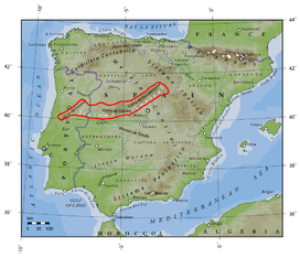
The Central System, Spanish and Portuguese: Sistema Central, is one of the main systems of mountain ranges in the Iberian Peninsula. The 2,592 m high Pico Almanzor is its highest summit.
| Central System | |
|---|---|
| Sistema Central | |
 View of La Serrota, 2.294 m, in Ávila Province | |
| Highest point | |
| Peak | Pico Almanzor |
| Elevation | 2,592 m (8,504 ft) |
| Coordinates | 40°14′48″N 05°17′52″W |
| Dimensions | |
| Length | 600 km (370 mi) ENE - WSW |
| Width | 30 km (19 mi) NNW - SSE |
| Geography | |
 Location of the Sistema Central in the Iberian Peninsula
| |
| Countries | Spain and Portugal |
| Communities | Extremadura, Castile-La Mancha and Castile and León |
| Districts | Guarda and Castelo Branco |
| Geology | |
| Orogeny | Alpine |
| Age of rock | Tertiary |
| Type of rock | Limestone and sandstone |
The Central System is located just north of the 40th parallel and its ranges divide the drainage basin of the Tagus from the basin of the Douro.
Description
The Sistema Central is a primary feature of the Meseta Central, the inner Iberian plateau, splitting the meseta into two parts. The Sistema Central runs in an ENE - WSW direction roughly along the southern border of the Spanish autonomous community of Castile and León and Extremadura continuing into the Guarda and Castelo Branco districts in Portugal.
Unlike the neighboring Sistema Ibérico, the Sistema Central range is a quite homogeneous system. It consists of several ranges that formed 25 million years ago as part of the Alpine orogeny.
The major mountain ranges are the Sierra de Guadarrama, which runs approximately along the border of the Madrid and Castile and León autonomous communities, the Sierra de Gredos north of the border between Castile and León and Castile-La Mancha stretching into Extremadura and containing the range's highest mountain, Pico Almanzor, at 2,592 m, as well as the Serra da Estrela, containing the highest point in continental Portugal, A Torre, 1,993 m. Other notably large ranges are Sierra de Gata and Sierra de Ayllón. The Central System links with the Sistema Ibérico at its eastern end through the Sierra de Pela, the Altos de Barahona and Sierra Ministra, the latter already fully part of the Iberian System.[1]
"Sistema Central" is a widely known academic geographical term. Local inhabitants, however, generally refer to the Sistema Central by the names of its smaller constituent ranges.
Mountain ranges
The main ranges of the Sistema Central from west to east followed by their highest points are:
- Serra da Lousã, Trevim, 1,205 m.
- Serra do Moradal
- Serra da Estrela, Torre, 1,993 m.
- Sierra de Gata, Jálama, 1,492 m.
- Sierra de la Canchera, Pico Tiendas, 1,590 m
- Sierra de Francia, Pico de la Hastiala, 1,735 m.
- Sierra de Béjar, Canchal de la Ceja, 2,430 m.
- Sierra de Gredos, Pico Almanzor, 2,592 m.
- Sierra de la Horcajada, Risco de la Umbrela, 1,562 m.
- Sierra de Villafranca, Cerro Moros, 2,059 m.
- Sierra de Piedra Aguda, Piedra Aguda, 1,817 m.
- La Serrota, Cerro del Santo, 2,294 m.
- Sierra de Hoyocasero, Navasolana, 1,708 m.
- Sierra de la Paramera, Pico Zapatero, 2,160 m.
- Sierra de Ávila, Cerro de Gorría, 1,708 m.
- Sierra de Ojos Albos, Cruz de Hierro, 1,657 m.
- Sierra de Malagón, Cueva Valiente, 1,903 m.
- Sierra de San Vicente, Cruces, 1,373 m.
- Sierra de Guadarrama, Peñalara, 2,428 m.
- La Mujer Muerta, La Pinareja, 2,197 m.
- Siete Picos, Siete Picos, 2,138 m.
- La Maliciosa, Maliciosa, 2,227 m.
- Cuerda Larga, Cabeza de Hierro Mayor, 2,383 m.
- Sierra de la Morcuera, La Najarra, 2,122 m.
- Sierra de Canencia, Mondalindo, 1,831 m.
- Sierra de la Cabrera, Cancho Largo, 1,564 m.
- Sierra de Somosierra, Colgadizos, 1,834 m.
- Sierra de Ayllón, Pico del Lobo, 2,274 m.
- Sierra de la Puebla, La Tornera, 1,866 m.
- Sierra del Ocejón, Ocejón, 2,049 m.
- Sierra de Alto Rey, Alto Rey, 1,858 m.
- Sierra de Pela, Sima de Somolinos, 1,548 m.
Main ranges and features
 View of the Serra da Estrela, containing the highest point in continental Portugal
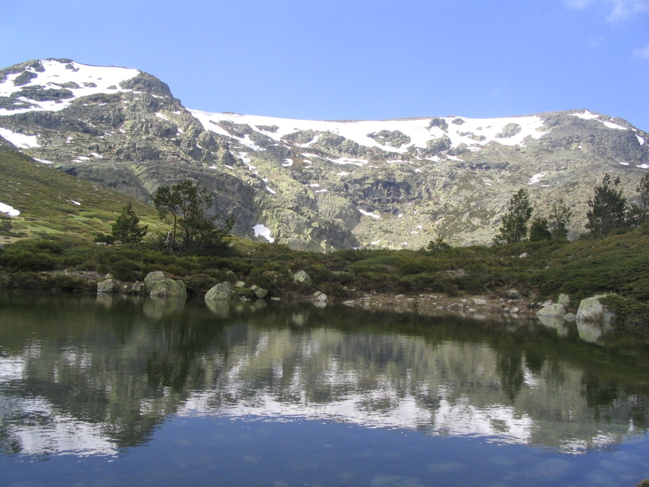
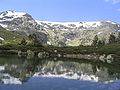 Alpine lake at Peñalara, Sierra de Guadarrama
 A view of the Sierra de Gata peaks in the background over a mountain village
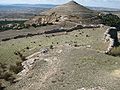 Cerro del Padrastro hill close to Atienza, in the transition zone between the Sistema Central and the Sistema Ibérico


See also
- Geography of Spain, section "The Inner Plateau and associated mountains"
- Sierra de Guadarrama
- Las Hurdes
- List of mountain ranges in the world named The Sleeping Lady
- Topographical relief of Spain
References
- Wes Gibbons & Teresa Moreno, The geology of Spain. Geological Society of London, 2003
External links
- Physical geography and geology of Spain
- Virtual Cadastral
- Sistema Central in Montipedia
- Ascensión al Mondalindo
- Subida al Ocejón
- Ascensión a la Sierra de la Puebla
- Al cobijo de los Altos de Barahona
Mountain ranges of Spain | ||
|---|---|---|
| ||
Authority control | |
|---|---|
| General |
|
| National libraries | |
На других языках
[de] Iberisches Scheidegebirge
Das Iberische Scheidegebirge (auch Kastilisches Scheidegebirge, Zentralkordillere sowie spanisch-portugiesisch: Sistema Central oder Cordillera Central) ist ein Gebirgssystem im Zentrum der Iberischen Halbinsel. Die höchste Erhebung der Bergkette ist der Berg Pico Almanzor mit 2592 m Höhe, der sich in der Sierra de Gredos befindet.- [en] Sistema Central
[es] Sistema Central
El sistema Central es una cordillera situada en el centro de la península ibérica que atraviesa la denominada Meseta Central. Con una orientación oeste-este en su mitad occidental, y suroeste-noreste en su mitad oriental, tiene una longitud aproximada de 600 km y se extiende desde el centro de Portugal hasta el sistema Ibérico, en el centro-noreste de España. Constituye la divisoria entre la submeseta norte y la submeseta sur, además de, administrativamente, la separación natural entre la comunidad autónoma de Castilla y León,[nota 1] al norte, y las de Castilla-La Mancha, Comunidad de Madrid y Extremadura, al sur. Salvo alguna excepción menor, constituye también la divisoria entre las cuencas de los ríos Duero y Tajo.[fr] Système central
Le Système central est une chaîne de montagnes située au centre de la péninsule Ibérique qui a une orientation ouest/est dans sa moitié ouest, et une orientation sud-ouest/nord-est dans sa moitié est. Elle a une longueur d'environ 700 km et s'étend depuis le Portugal jusqu'au Système ibérique. Elle constitue la séparation naturelle entre Castille-et-León, au nord, et Castille-La Manche, la Communauté de Madrid et l'Estrémadure, au sud. Elle représente également la division du plateau central ibérique entre sous-plateau nord et sous-plateau sud. Hormis quelques exceptions mineures, elle marque la division entre le bassin du Duero et celui du Tage. Le plus haut sommet du système est le pic Almanzor (2 591 mètres), situé dans la sierra de Gredos. Les montagnes du Système central ont une proéminence moyenne de 1 200 mètres et une base comprise entre 500 et 1 200 mètres.[ru] Центральная Кордильера (Пиренейский полуостров)
Центра́льная Кордилье́ра (исп. Cordillera Central) — горная цепь в центральной части Пиренейского полуострова. Расположена главным образом на территории Испании, часть в Португалии. Длина около 400 км. Самая высокая точка — гора Альмансор (2592 м) в массиве Сьерра-де-Гредос.Другой контент может иметь иную лицензию. Перед использованием материалов сайта WikiSort.org внимательно изучите правила лицензирования конкретных элементов наполнения сайта.
WikiSort.org - проект по пересортировке и дополнению контента Википедии