geo.wikisort.org - River
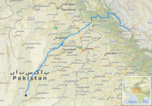
The Chenab River (/tʃɪˈnæb/) is a major river that flows in India and Pakistan, and is one of the 5 major rivers of the Punjab region. It is formed by the union of two headwaters, Chandra and Bhaga, which rise in the upper Himalayas in the Lahaul region of Himachal Pradesh, India. The Chenab flows through the Jammu region of Jammu and Kashmir, India into the plains of Punjab, Pakistan, before ultimately flowing into the Indus River.
| Chenab | |
|---|---|
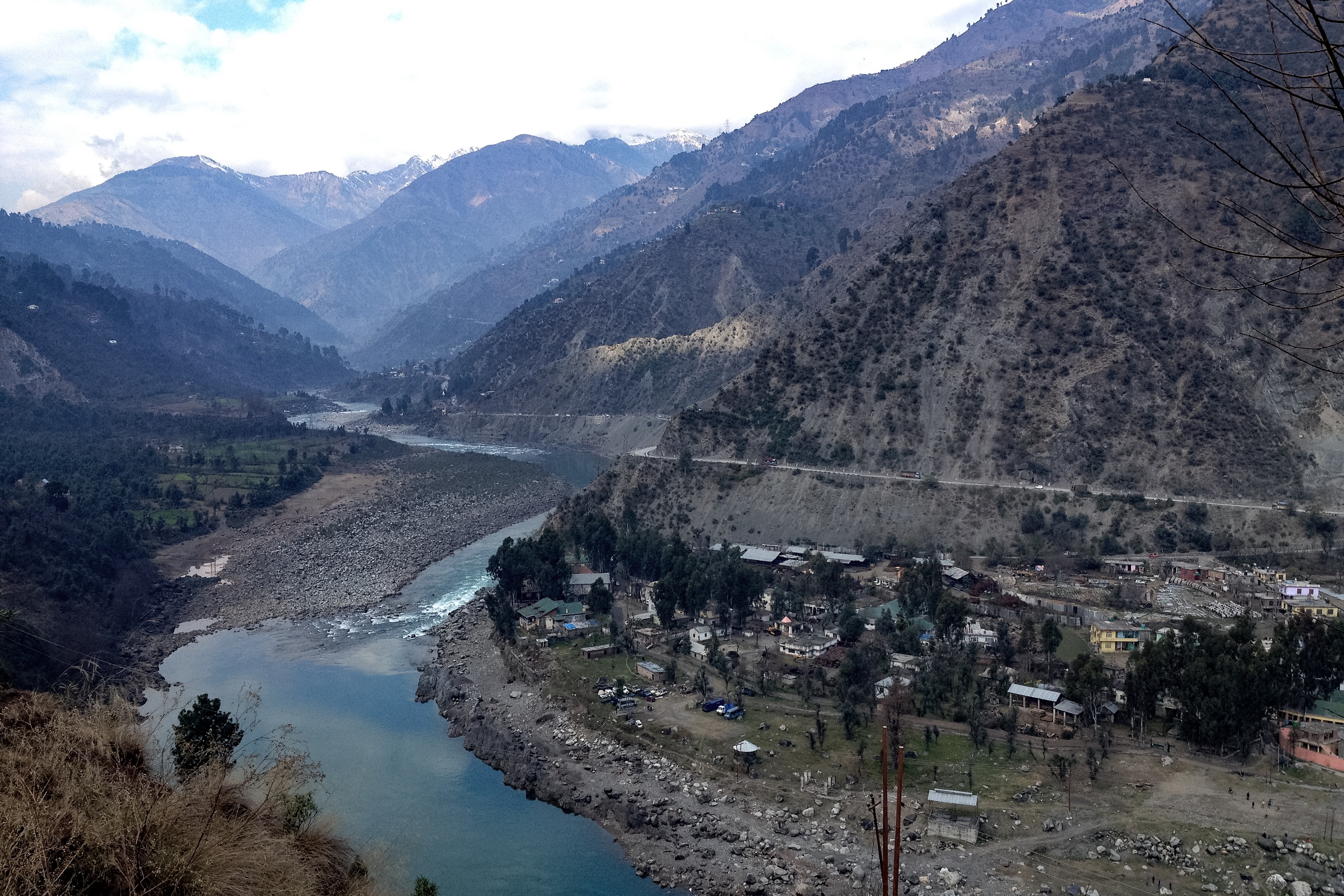 River Chenab at Ramban, Jammu and Kashmir | |
 | |
| Location | |
| Country | India, Pakistan |
| Flows through (areas in India) | Himachal Pradesh, Jammu and Kashmir |
| Flows through (areas in Pakistan) | Punjab |
| Physical characteristics | |
| Source | Baralacha La pass |
| • location | Lahul and Spiti district, Himachal Pradesh, India |
| • coordinates | 32°38′09″N 77°28′51″E |
| Mouth | Confluence with Sutlej to form the Panjnad River |
• location | Bahawalpur district, Punjab, Pakistan |
• coordinates | 29°20′57″N 71°1′41″E |
| Length | 1,200 km (750 mi)approx. |
| Discharge | |
| • location | Marala Headworks[1] |
| • average | 977.3 m3/s (34,510 cu ft/s) |
| • minimum | 310.53 m3/s (10,966 cu ft/s) |
| • maximum | 31,148.53 m3/s (1,100,000 cu ft/s) |
| Basin features | |
| River system | Indus River |
| Tributaries | |
| • left | Tawi River, Ravi River |
| • right | Marusudar River,[2] Jhelum River, Neeru river |
The waters of the Chenab were allocated to Pakistan under the terms of the Indus Waters Treaty. India is allowed non-consumptive uses such as power generation. The Chenab River is extensively used in Pakistan for irrigation. Its waters are also transferred to the channel of the Ravi River via numerous link canals.[3][4][5]
Name
The Chenab river was called Asikni (Sanskrit: असिक्नी) in the Rigveda (VIII.20.25, X.75.5). The name meant that it was seen to have dark-coloured waters.[6][7] The term Krishana is also found in the Atharvaveda.[8] A later form of Askikni was Iskamati (Sanskrit: इस्कामति)[citation needed] and the Greek form was Ancient Greek: Ἀκεσίνης - Akesínes; Latinized to Acesines.[6][7][9]
In the Mahabharata, the common name of the river was Chandrabhaga (Sanskrit: चन्द्रभागा) because the river is formed from the confluence of the Chandra and the Bhaga rivers.[8][10] This name was also known to the Ancient Greeks, who Hellenised it in various forms such as Sandrophagos, Sandabaga and Cantabra.[7]
The simplification of Chandrabhaga to 'Chenab', with evident Persianate influence, probably occurred in early medieval times and is witnessed in Alberuni.[11]
Course


The river is formed by the confluence of two rivers, Chandra and Bhaga, at Tandi, 8 km (5.0 mi) southwest of Keylong, in the Lahaul and Spiti district of the Indian state of Himachal Pradesh.[3]
The Bhaga river originates from Surya taal lake, which is situated a few kilometers west of the Bara-lacha la pass in Himachal Pradesh. The Chandra river originates from glaciers east of the same pass (near Chandra Taal).[3][12] This pass also acts as a water-divide between these two rivers.[13] The Chandra river transverses 115 km (71 mi) while the Bhaga river transverses 60 km (37 mi) through narrow gorges before their confluence at Tandi.[14]
The Chandra-Bhaga then flows through the Chamba district in Himachal Pradesh before entering the Jammu division of Jammu and Kashmir, where it flows through the Kishtwar, Doda, Ramban, Reasi and Jammu districts. It enters Pakistan and flows through the Punjab province before emptying into the Sutlej, forming the Panjnad river.
History
The river was known to Indians in the Vedic period.[15][16][17] In 325 BCE, Alexander the Great allegedly founded the town of Alexandria on the Indus (present day Uch Sharif or Mithankot or Chacharan in Pakistan) at the confluence of the Indus and the combined streams of Punjab rivers (currently known as the Panjnad River).[18]
Dams

The river has rich power generation potential in India. There are many dams built, under construction or proposed to be built on the Chenab for the purpose of hydroelectric power generation in the country, including:
- Baglihar Hydroelectric power project (900 MW) near Ramban
- Salal Dam - 690 MW hydroelectric power project near Reasi
- Dul Hasti Hydroelectric Plant - 390 MW type power project in Kishtwar District
- Ratle Hydroelectric Plant - an under-construction power station near Drabshalla in Kishtwar District
- Pakal Dul Dam - a proposed dam on a tributary Marusadar River in Kishtwar District
- Kiru Hydroelectric Power Project (624 MW proposed) located in Kishtwar district
- Kishtwar Hydroelectric Power Project (540 MW proposed) located in Kishtwar district
All of these are "run-of-the-river" projects as per the Indus Water Treaty of 1960. The Treaty allocates the waters of Chenab to Pakistan. India can use its water for domestic and agricultural uses or for "non-consumptive" uses such as hydro power. India is entitled to store up to 1.2 million acre-feet (1.5 billion cubic metres) of water in its projects. The three projects completed as of 2011[update], Salal, Baglihar and Dul Hasti, have a combined storage capacity of 260 thousand acre-feet (320 million cubic metres).[19]

Pakistan has four headworks on the Chenab:
- Marala Headworks - located near Sialkot
- Khanki Headworks - located in Gujranwala District
- Qadirabad Headworks - located in Mandi Bahauddin District
- Trimmu Barrage - located in Jhang District
See also
References
- ftp://daac.ornl.gov/data/rivdis/STATIONS.HTM%5B%5D, ORNL, Retrieved 8 Dec 2016
- "Construction of power projects over Chenab". Business Recorder. 26 August 2013. Retrieved 16 March 2017.
- Naqvi, Saiyid Ali (2012), Indus Waters and Social Change: The Evolution and Transition of Agrarian Society in Pakistan, Oxford University Press Pakistan, p. 13, ISBN 978-0-19-906396-3
- "River Chenab" (PDF). Archived from the original (PDF) on 27 September 2007.
- "Indus Waters Treaty". The World Bank. Retrieved 8 December 2016.
- Kapoor, Subodh (2002), Encyclopaedia of Ancient Indian Geography, Cosmo Publications, p. 80, ISBN 978-81-7755-298-0
- Kaul, Antiquities of the Chenāb Valley in Jammu 2001, p. 1.
- Kaul, Antiquities of the Chenāb Valley in Jammu 2001, p. 2.
-
 Smith, William, ed. (1854–1857). "Acesines". Dictionary of Greek and Roman Geography. London: John Murray.
 - Handa, O. C.; Omacanda Hāṇḍā (1994), Buddhist Art & Antiquities of Himachal Pradesh, Upto 8th Century A.D., Indus Publishing, pp. 126–, ISBN 978-81-85182-99-5
- Kazmi, Hasan Askari (1995), The makers of medieval Muslim geography: Alberuni, Renaissance, p. 124, ISBN 9788185199610
- Gosal, G.S. (2004). "Physical Geography of the Punjab" (PDF). Journal of Punjab Studies. Center for Sikh and Punjab Studies, University of California. 11 (1): 31. ISSN 0971-5223. Archived from the original (PDF) on 8 June 2012. Retrieved 6 August 2009.
- R. K. Pant; N. R. Phadtare; L. S. Chamyal & Navin Juyal (June 2005). "Quaternary deposits in Ladakh and Karakoram Himalaya: A treasure trove of the palaeoclimate records" (PDF). Current Science. 88 (11): 1789–1798. Retrieved 6 August 2009.
- "Lahaul & Spiti". Archived from the original on 16 April 2019. Retrieved 7 August 2018.
- Yule, Henry; Burnell, Arthur Coke; Crooke, William (1903). Hobson-Jobson: A glossary of Anglo-Indian colloquial words & phrases and of kindred terms. Murray. p. 741.
chenab ancient name.
- "River, Chenab River on Encyclopædia Britannica". Retrieved 8 December 2016.
- Encyclopædia Britannica article on the Chenab
- Alexandria (Uch)
- Bakshi, Gitanjali; Trivedi, Sahiba (2011), The Indus Equation (PDF), Strategic Foresight Group, p. 29, retrieved 28 October 2014
Bibliography
- Kaul, P. K. (2001), Antiquities of the Chenāb Valley in Jammu: Inscriptions-copper Plates, Sanads, Grants, Firmāns & Letters in Brāhmi-Shārdā-Tākri-Persian & Devnāgri Scripts, Eastern Book Linkers, ISBN 9788178540061
External links
- Chenab River in the context of Pakistan - by Pakistan Tourism Portal
| Inland |
|
|---|---|
| Coastal |
|
| Categories |
|
Geography of Himachal Pradesh | ||
|---|---|---|
| Lakes |  | |
| Rivers | ||
| Districts | ||
| Other |
| |
Punjab geography | ||
|---|---|---|
| ||
Authority control | |
|---|---|
| General |
|
| National libraries | |
На других языках
[de] Chanab
Der Chanab oder Chenab (Hindi: .mw-parser-output .Deva{font-size:120%}@media all and (min-width:800px){.mw-parser-output .Deva{font-size:calc(120% - ((100vw - 800px)/80))}}@media all and (min-width:1000px){.mw-parser-output .Deva{font-size:100%}}चेनब cenab; Panjabi .mw-parser-output .Arab a,.mw-parser-output a bdi.Arab{text-decoration:none!important}.mw-parser-output .Arab{font-size:120%}ਚਨਾਬ, canāb; Urdu چناب) ist ein Fluss in Indien und Pakistan mit einer Länge von 1242 Kilometern.- [en] Chenab River
[es] Río Chenab
El río Chenab es un largo río que discurre por el subcontinente indio, uno de los cinco ríos que fluyen por el Punyab en el noroeste de la India y noreste de Pakistán. La longitud total del río varía según las fuentes, yendo desde 960 km hasta los 1242 km.[cita requerida][it] Chenab
Il Chenab (punjabi: ਚਨਾਬ, canāb, urdu: چناب, hindi: चनाब, letteralmente: "Fiume (ab) della Luna (chen)") è un fiume formato dalla confluenza del Chandra e del Bhaga a Tandi, nell'Himalaya, nel distretto di Lahaul e Spiti nell'Himachal Pradesh (India). Il suo corso superiore è conosciuto anche come il Chandrabhaga. Esso attraversa il Jammu e Kashmir verso le pianure del Punjab, dove raggiunge il Jhelum a Trimmu e il Ravi. Si getta nel Sutlej vicino a Uch Sharif per formare il Panjnad o "Cinque Fiumi" (il quinto è il Beas, che si getta a sua volta nel Sutlej vicino a Ferozepur, in India). Il Sutlej sfocia poi nell'Indo a Mithankot. La lunghezza totale del Chenab è di circa 960 km. Le sue acque sono assegnate al Pakistan secondo il Trattato delle acque dell'Indo.[1][2][ru] Чинаб
Чина́б[1][2], Ченаб (хинди चनाब, Чанаб[3]; урду چناب) — река в Индии и Пакистане, правый приток реки Сатледж (бассейн Инда). Длина — 1100 км, площадь бассейна — 138 тысяч км²[4].Другой контент может иметь иную лицензию. Перед использованием материалов сайта WikiSort.org внимательно изучите правила лицензирования конкретных элементов наполнения сайта.
WikiSort.org - проект по пересортировке и дополнению контента Википедии