geo.wikisort.org - River
The Gilgit River (Urdu: دریائے گلگت) is a tributary of the Indus River, and flows through the Gupis-Yasin, Ghizer and Gilgit districts of Gilgit-Baltistan. The Gilgit River starts from Shandur Lake,[1] and joins the Indus River at near towns of Juglot and Bunji, where also the three mountain ranges of Hindu Kush, Himalaya and Karakoram ranges are believed to meet.[2][3] The upper sections of the Gilgit river are called Gupis River and Ghizer River.

| Gilgit River | |
|---|---|
 | |
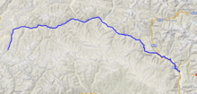 Course of the Gilgit River | |
| Native name | دریائے گلگت (Urdu) |
| Location | |
| Country | Pakistan |
| Autonomous Territory | Gilgit-Baltistan |
| Districts | Gupis-Yasin, Ghizer and Gilgit |
| Physical characteristics | |
| Mouth | |
• coordinates | 35°44′31″N 74°37′29″E |
| Length | 240 km |
| Basin features | |
| Waterbodies | Shandur Lake, Phander Lake, Attabad Lake |
See also
References
- isbn:1483603792 - Cerca con Google (in Italian).
- Handy, Norman (2017). K2, The Savage Mountain: Travels in Northern Pakistan. novum pro Verlag. ISBN 9783990487174.
- Dani, Ahmad Hasan; Masson, Vadim Mikhaĭlovich (2003). History of Civilizations of Central Asia: Development in contrast : from the sixteenth to the mid-nineteenth century. UNESCO. ISBN 9789231038761.
| Wikimedia Commons has media related to Gilgit River. |
Authority control | |
|---|---|
| General |
|
| National libraries | |
На других языках
[de] Gilgit (Fluss)
Der 240 Kilometer[2] lange Fluss Gilgit (Urdu .mw-parser-output .Arab a,.mw-parser-output a bdi.Arab{text-decoration:none!important}.mw-parser-output .Arab{font-size:120%}دریائے گلگت .mw-parser-output .Latn{font-family:"Akzidenz Grotesk","Arial","Avant Garde Gothic","Calibri","Futura","Geneva","Gill Sans","Helvetica","Lucida Grande","Lucida Sans Unicode","Lucida Grande","Stone Sans","Tahoma","Trebuchet","Univers","Verdana"}daryā-e Gilgit; oberhalb von Gahkuch heißt der Fluss Ghizer) entspringt am Shandur-See auf einer Gebirgshochebene.- [en] Gilgit River
[it] Gilgit (fiume)
Il fiume Gilgit (Urdu:دریائے گلگت) è un tributario dell'Indo e si trova in Pakistan, nel Gilgit-Baltistan. Il fiume, che ha una lunghezza di 240 km, ha origine dal lago Shandur (a 3.700 m, .mw-parser-output .geo-default,.mw-parser-output .geo-dms,.mw-parser-output .geo-dec{display:inline}.mw-parser-output .geo-nondefault,.mw-parser-output .geo-multi-punct{display:none}.mw-parser-output .latitude,.mw-parser-output .longitude{white-space:nowrap}.mw-parser-output .geo{}body.skin-vector .mw-parser-output #coordinates{font-size:85%;line-height:1.5em;position:absolute;right:0;top:0;white-space:nowrap}36°04′44″N 72°32′07″E); attraversa la città di Gilgit e poco dopo si unisce al fiume Hunza per sfociare poi nell'Indo[1].[ru] Гилгит (река)
Ги́лгит (урду دریائے گلگت) — река в Гилгит-Балтистане.Текст в блоке "Читать" взят с сайта "Википедия" и доступен по лицензии Creative Commons Attribution-ShareAlike; в отдельных случаях могут действовать дополнительные условия.
Другой контент может иметь иную лицензию. Перед использованием материалов сайта WikiSort.org внимательно изучите правила лицензирования конкретных элементов наполнения сайта.
Другой контент может иметь иную лицензию. Перед использованием материалов сайта WikiSort.org внимательно изучите правила лицензирования конкретных элементов наполнения сайта.
2019-2026
WikiSort.org - проект по пересортировке и дополнению контента Википедии
WikiSort.org - проект по пересортировке и дополнению контента Википедии