geo.wikisort.org - River
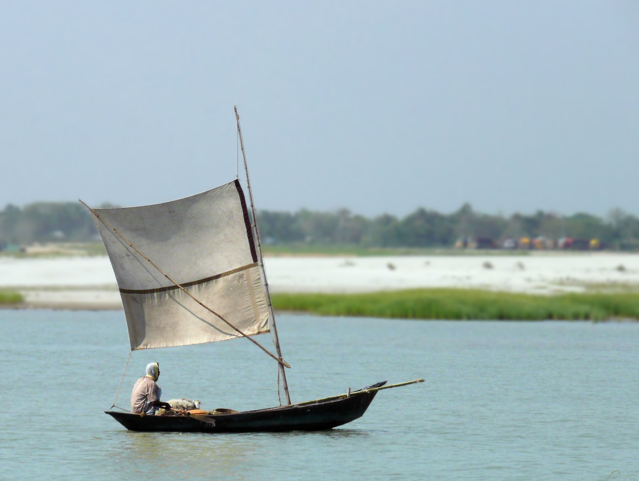
The Padma (Bengali: পদ্মা Pôdma) is a major river in Bangladesh. It is the main distributary of the Ganges, flowing generally southeast for 356 kilometres (221 mi) to its confluence with the Meghna River near the Bay of Bengal.[1] The city of Rajshahi is situated on the banks of the river.[2] Since 1966, over 660 square kilometres (256 sq mi) of land has been lost due to erosion of the Padma.[3]
| Padma River পদ্মা নদী (Previous name: কীর্তিনাশা) | |
|---|---|
 Padma River in Bangladesh | |
| Location | |
| Countries | Bangladesh |
| Districts | |
| Physical characteristics | |
| Source | |
| • location | Bifurcation of the Ganges at Giria, India, and The Gangotri Glacier in the middle of Himalayans |
| Mouth | |
• location | Bay of Bengal |
| Length | 356 kilometres (221 mi)[1] |
| Discharge | |
| • average | Annual average:
During monsoon season:
During dry season:
|
| Basin features | |
| River system | Ganges River System |
| Bridges | Padma Bridge Lalon Shah Bridge Hardinge Bridge |
History
Etymology
The Padma, Sanskrit for lotus flower, is a mentioned in Hindu mythology as a byname for the Goddess Lakshmi.[4]
The name Padma is given to the lower part of the course of the Ganges (Ganga) below the point of the off-take of the Bhagirathi River (India), another Ganges River distributary also known as the Hooghly River. Padma had, most probably, flowed through a number of channels at different times. Some authors contend that each distributary of the Ganges in its deltaic part is a remnant of an old principal channel, and that starting from the westernmost one, the Bhagirathi (in West Bengal, India), each distributary to the east marks a position of a newer channel than the one to the west of it.
Geographic effects

Eighteenth-century geographer James Rennell referred to a former course of the Ganges north of its present channel, as follows:
Appearances favour very strongly the opinion, that the Ganges had its former bed in the tract now occupied by the lakes and morasses between Nattore and Jaffiergunge, striking out of the present course at Bauleah ... to a junction with the Burrampooter or Megna near Fringybazar; where the accumulation of two such mighty streams probably scooped out the present amazing bed of the Megna.[5]

The places mentioned by Rennell proceeding from west to east are Rampur Boali, the headquarters of Rajshahi district, Puthia and Natore in the same district and Jaffarganj in the district of Dhaka. The place last named were shown in a map of the Mymensingh district dated 1861, as a subdistrict (thana) headquarters, about 10 kilometres (6 mi) south-east of Bera Upazila police station. It is now known as Payla Jaffarganj and is close to Elachipur opposite Goalunda. According to Rennell's theory, therefore, the probable former course of the Ganges would correspond with that of the present channel of the Baral River.[citation needed]
Authorities agree that the Ganges has changed its course and that at different times, each of the distributaries might have been the carrier of its main stream.[citation needed]
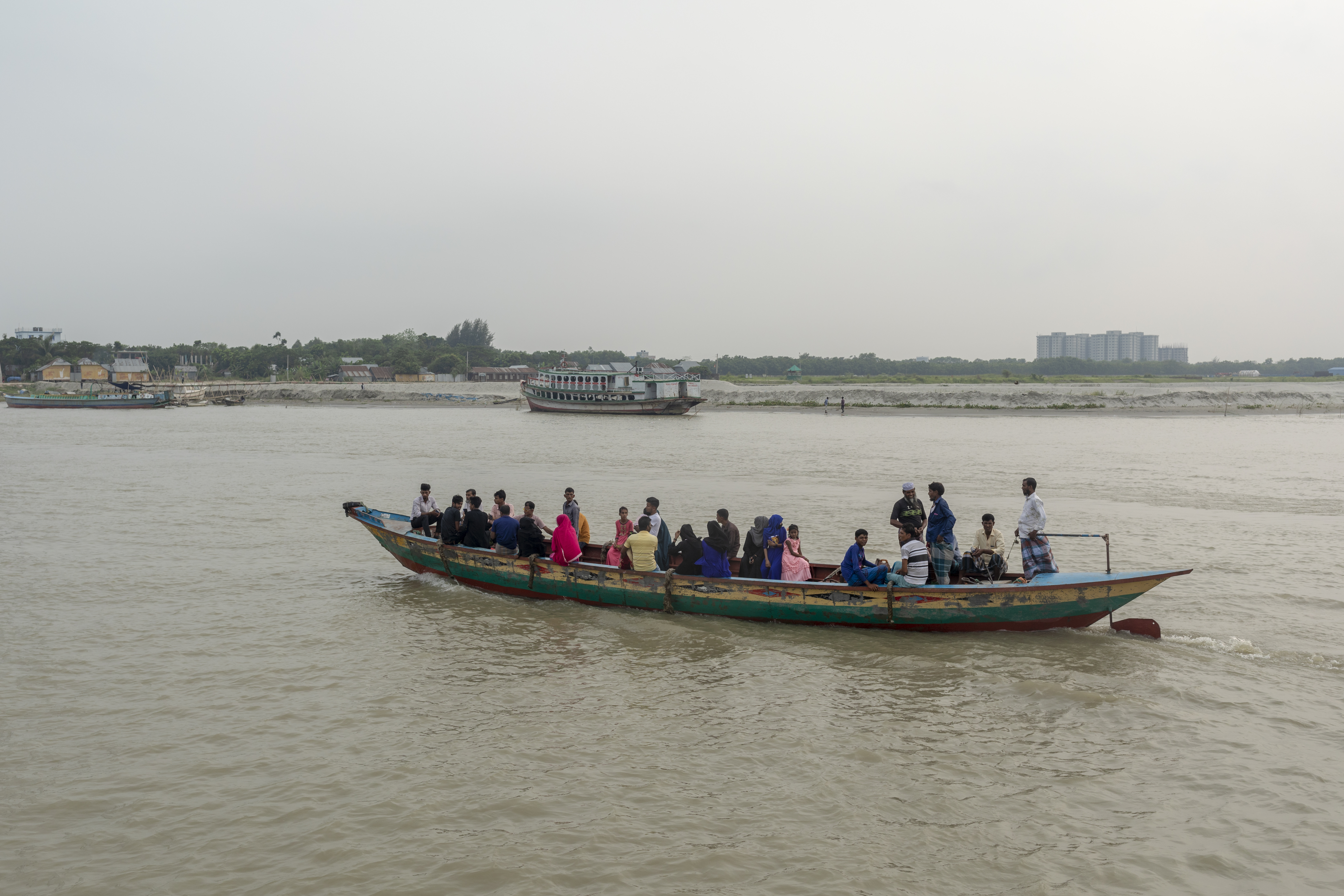
The bed of the Padma is wide, and the river is split up into several channels flowing between constantly shifting sand banks and islands. During the rains the current is very strong and even steamers may find difficulty in making headway against it. It is navigable at all seasons of the year by steamers and country boats of all sizes and until recently ranked as one of the most frequented waterways in the world. It is spanned near Paksey by the great Hardinge Bridge over which runs one of the main lines of the Bangladesh Railway.[citation needed]

Geography
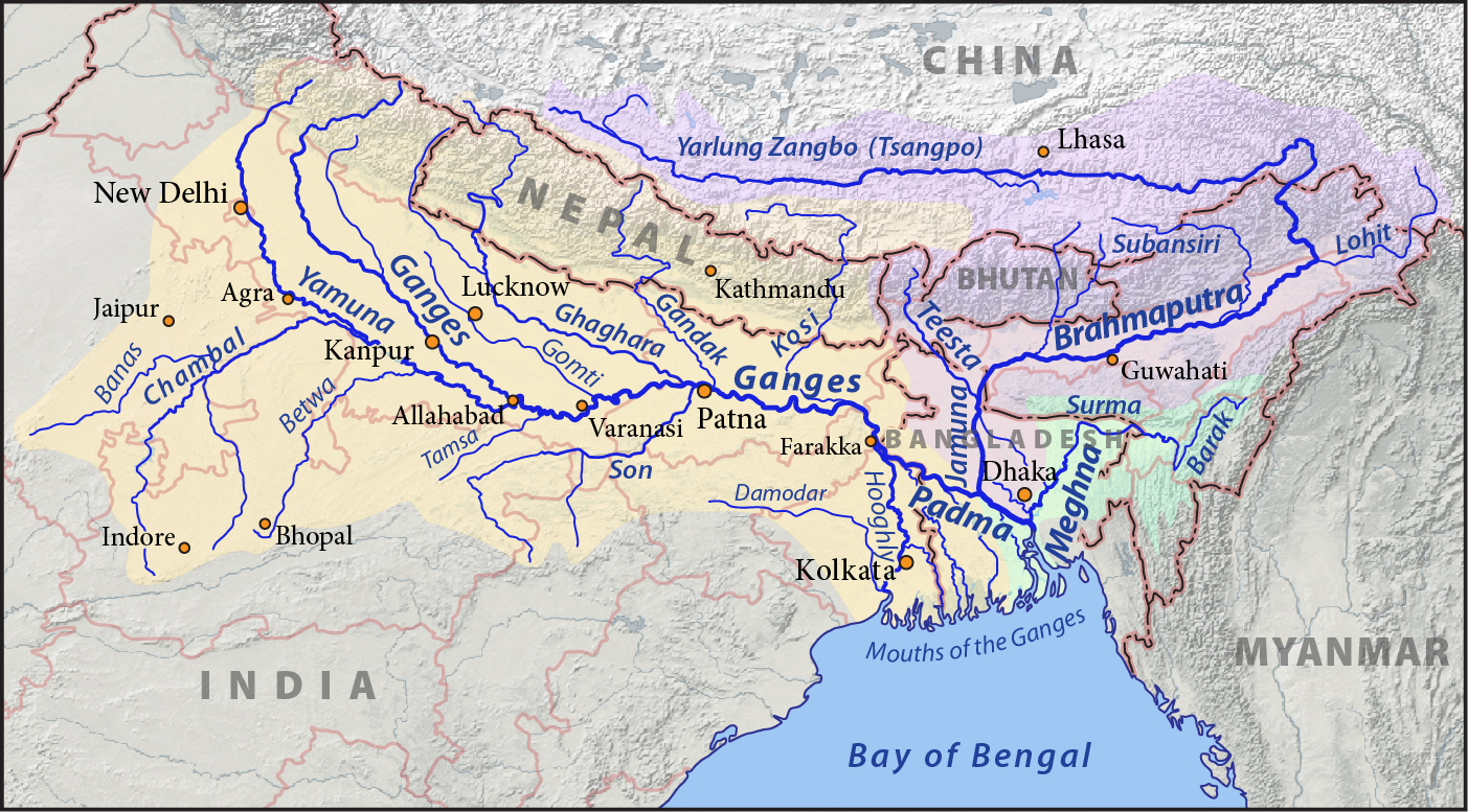
The Padma enters Bangladesh from India near Nawabganj and meets the Jamuna (Bengali: যমুনা Jomuna) near Aricha and retains its name, but finally meets with the Meghna (Bengali: মেঘনা) near Chandpur and adopts the name "Meghna" before flowing into the Bay of Bengal.
Rajshahi, a major city in western Bangladesh, is situated on the north bank of the Padma.
The Ganges originates in the Gangotri Glacier of the Himalaya, and runs through India and Bangladesh to the Bay of Bengal. The Padma enters Bangladesh at Shibganj in the district of Chapai Nababganj. The Ganges branches into two distributaries, the Hooghly and the Padma at Giria in Murshidabad district of India . The Hooghly River, which continues southwards in India is also known as the Ganga (traditionally) and Bhagirathi.
Further downstream, in Goalando, 2,200 kilometres (1,400 mi) from the source, the Padma is joined by the Jamuna (Lower Brahmaputra) and the resulting combination flows with the name Padma further east, to Chandpur. Here, the widest river in Bangladesh, the Meghna joins the Padma, continuing as the Meghna almost in a straight line to the south, ending in the Bay of Bengal.

Pabna District

The Padma forms the whole of the southern boundary of the Pabna District for a distance of about 120 kilometres (75 mi).
Kushtia District
The Jalangi River is thrown off at the point where the mighty Padma touches the district at its most northernly corner, and flows along the northern border in a direction slightly southeast, until it leaves the district several kilometres to the east of Kushtia. It carries immense volumes of water and is very wide at places, constantly shifting its main channel, eroding vast areas on one bank, throwing chars on the other, giving rise to many disputes as to the possession of the chars and islands which are thrown up.
Murshidabad District
Murshidabad District situated on the western bank of The Padma. It flows dividing the Rajshahi and Murshidabad District of West Bengal and created a natural river border between India and Bangladesh.[6][7] Jalangi area of the district was seriously affected by River bank erosion of Padma.[8]
Rajshahi District
Rajshahi is the largest city among the cities which is situated on the bank of Padma river. It is the third largest city in Bangladesh. It is a major city in the north Bengal. Rajshahi has a decorated embankment of Padma. Rajshahi Collegiate School is one of the oldest schools in Indian Subcontinent, situated on Padma river bank. The school was endangered three times by the disintegration of the Padma river. Padma Food Garden, A.H.M. Kamaruzzaman Central Park and Zoo, Barokuthi Nandan Park, Muktamancha, and 'T' shaped embankment (Bengali: টি বাঁধ) are best tourist spot in Rajshahi which are situated on the bank of Padma river.

Infrastructure

Damming
After the construction of the Farakka Barrage on the Ganges River in West Bengal, the maximum flows in the Padma River were reduced significantly. The flow reduction caused many problems in Bangladesh, including the loss of fish species, the drying of Padma's distributaries, increased saltwater intrusion from the Bay of Bengal, and damage to the mangrove forests of the Sundarbans.[9]
Padma Bridge
The Padma Bridge is the Bangladesh's largest, estimated at US$3 billion to finish. The bridge was inaugurated on 25 June 2022.[10] It was supposed to be open to the public in 2013. However, the future of the project became uncertain when in June 2012 the World Bank cancelled its $1.2 billion loan over corruption allegations.[11] In June 2014, the government of Bangladesh, proceeding without the loan, hired a Chinese firm to construct the 6.15-kilometre (3.82 mi) main part of the bridge; in October 2014, it hired a South Korean firm to supervise construction, with the aim of finishing the project by 2018.[12] The final (41st) span of the bridge was installed on 10 December 2020.[13][14] The last road slab was installed on the span that linked the pillars 12 and 13 of the Padma bridge on 24 August 2021.[15][16]
In 2009, government plans also included rail lines on both sides of the Padma with a connection via the new bridge.[17][needs update]
The Lalon Shah Bridge and Hardinge Bridge also crosses the Padma further upstream.
See also
- Ganges Barrage Project
- Railway stations in Bangladesh
References
- Allison, Mead A. (Summer 1998). "Geologic Framework and Environmental Status of the Ganges-Brahmaputra Delta". Journal of Coastal Research. Coastal Education & Research Foundation, Inc. 13 (3): 826–836. JSTOR 4298836.
- Hossain ML, Mahmud J, Islam J, Khokon ZH and Islam S (eds.) (2005) Padma, Tatthyakosh Vol. 1 and 2, Dhaka, Bangladesh, p. 182 (in Bengali).
- "Over 66,000 hectares lost to Padma since 1967: NASA report". The Daily Star. Retrieved September 14, 2018.
- Williams, George M. (2008). Handbook of Hindu Mythology. Oxford University Press. p. 198. ISBN 978-0-19-533261-2.
- Rennell, James (January 1783). "Account of the Ganges and Burrampooter Rivers". The Scots Magazine. Vol. 45. p. 62. Retrieved 16 October 2014.
- "The Padma River". Retrieved February 11, 2018.
- "Ganga-Padma erosion poses security concerns in Bengal". August 19, 2013. Retrieved February 11, 2018.
- "River Bank Erosion Induced Human Displacement and Its Consequences – Impact of Ganges River Bank Erosion". Tuhin K. Das, Sushil K. Haldar, Ivy Das Gupta and Sayanti Sen. Living Reviews in Landscape Research. Retrieved 5 September 2017.
- Islam, Nazrul (29 April – 5 May 2006). "IRLP or the Ecological Approach to Rivers?". Economic and Political Weekly. 41 (17): 1693–1702. JSTOR 4418148.
- "Grand preparations made for Padma Bridge inauguration". The Daily Star. 24 June 2022. Retrieved 24 June 2022.
- "World Bank Statement on Padma Bridge" (Press release). World Bank Group. 29 June 2012. Retrieved 16 October 2014.
- Kallol, Assif Showkat (14 October 2014). "Korean Firm Gets Padma Bridge Construction Supervision Job". Dhaka Tribune. Retrieved 16 October 2014.
- "Last span of Padma Multipurpose Bridge installed". The Daily Star. 2020-12-10. Retrieved 2020-12-10.
- "Last span of Padma Multipurpose Bridge installed". Daily Sun. Retrieved 2020-12-10.
- "It's possible to walk across the Padma now". The Daily Star. 24 August 2021.
- "Padma Bridge likely to open to traffic by June 2022". Dhaka Tribune. Retrieved 22 December 2020.
- "Plan to Lay 80 km Rail Line on Both Sides of Padma Bridge". The Daily Star. BSS. 15 August 2009.
External links
- Chowdhury, Masud Hasan (2012). "Padma River". In Islam, Sirajul; Jamal, Ahmed A. (eds.). Banglapedia: National Encyclopedia of Bangladesh (Second ed.). Asiatic Society of Bangladesh.
| Authority control |
|
|---|
На других языках
[de] Padma
Die Padma (bengalisch: .mw-parser-output .Beng{font-size:110%}পদ্মা, Padmā, „Lotosblüte“) ist der knapp 120 Kilometer lange vorletzte Abschnitt des nach Volumen größten Stromes von Asien.- [en] Padma River
[es] Río Padma (Bangladés)
El río Padma (en bengalí, পদ্মা, romanizado Pôdda) es uno de los principales ríos transfronterizos de Bangladés, uno de los tramos inferiores y el principal distributario del Ganges (en bengalí, Gôngga), un largo río que proviene del Himalaya. A veces se suele decir que el Padma es el mismo río Ganges que cambia de nombre al ingresar en Bangladés.[it] Padma (fiume)
Il Padma è il canale principale del Gange (Ganga) in Bangladesh. Per circa 145 km il Gange forma il confine occidentale tra India e Bangladesh prima di entrare in quest'ultimo paese lungo il margine settentrionale del distretto di Kushtia sotto forma di tratto superiore del fiume Padma. Il Padma superiore scorre verso sud-est per ricevere le acque del maestoso fiume Jamuna (nome con il quale in Bangladesh è noto il Brahmaputra) nei pressi di Rajbari. Il corso combinato di questi due fiumi costituisce il segmento inferiore del Padma, che continua a scorrere verso sud-est attraverso il Bangladesh centrale per andare a congiungersi con il Meghna nei pressi di Chandpur e sfociare nel golfo del Bengala.[ru] Падма
Па́дма (англ. Padma, бенг. পদ্মা) — участок реки Ганг от впадения основного рукава реки Брахмапутры.Другой контент может иметь иную лицензию. Перед использованием материалов сайта WikiSort.org внимательно изучите правила лицензирования конкретных элементов наполнения сайта.
WikiSort.org - проект по пересортировке и дополнению контента Википедии