geo.wikisort.org - River
This is a list of rivers of India, starting in the west and moving along the Indian coast southward, then northward. Tributary rivers are listed hierarchically in upstream order: the lower in the list, the more upstream.
The overall discharge of rivers in India or passing/originating in India : List of rivers of India by discharge
The major rivers of India are:
- Flowing into the Arabian Sea: Narmada, Tapi, Sindhu, Sabarmati, Mahi, Purna
- Flowing into the Bay of Bengal: Brahmaputra, Yamuna, Ganga, Meghna, Mahanadi, Godavari, Krishna, Kaveri, Penna River
Mizoram and Bangladesh.
Meghna River Basin
The Meghna-Surma-Barak River System is located in India and Bangladesh.
- Meghna River (in the Bangladesh)
- Dhaleshwari River
- Dakatia River
- Gumti River
- Feni River
- Tista River, also called the Haora River
- Surma River
- Kushiyara River
- Manu River
- Barak River
- Tuivai River
- Irang River
Ganges River Basin
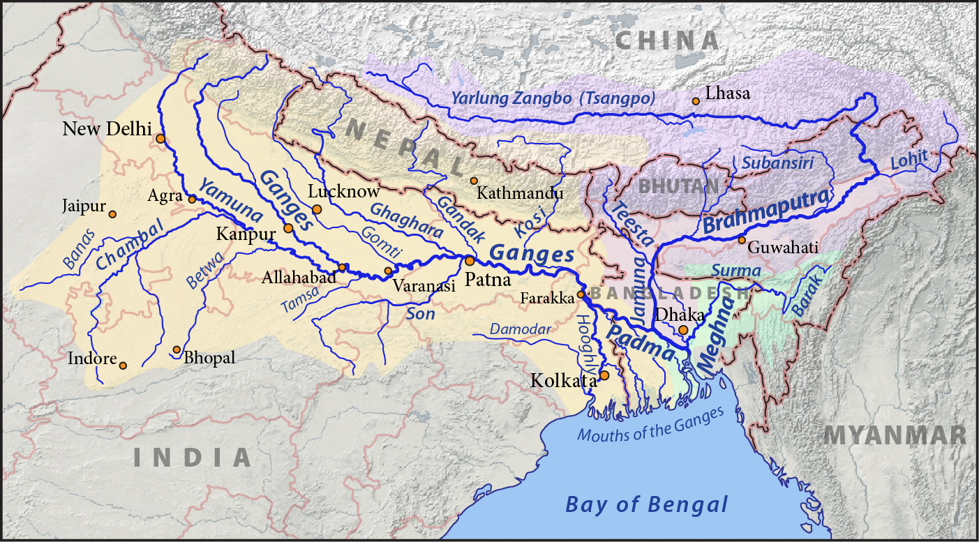

- Ganga River (known as Padma in Bangladesh)
-
- Brahmaputra
- Hooghly River (distributary)
- Damodar River
- Jahnavi River
- Jalangi River
- River Churni
- Ichamati River
- Rupnarayan River
- Ajay River
- Mayurakshi River
- Dwarakeswar River
- Mundeswari River
- Meghna River
- Punarbhaba River
- Atrai River
- Mahananda River
- Kosi River
- kamla River
- Bagmati River
- Bhurhi Gandak River
- Phalgu
- Gandaki River (also Gandak, known as Narayani in Nepal)
- Son River
- Kanhar River
- Theme
- Lanva, Pandu, Goita, Hathinala, Suria, Chana, Sendur, Kursa, Galphulla, Semarkhar, Riger and the Cherna Nallah
- North Koel River
- Rihand River
- Gopad River
- Goini River
- Neur River
- Banas River
- Johilla River
- Kanhar River
- Ghaghara River (sometimes spelled Gogra), called Karnali River in Nepal
- West Rapti River
- Sarda River (also known as Chauka), called Mahakali in Nepal, also known as the Kali River along the India–Nepal border
- Ladhiya River
- Sarayu River, or Sarju River
- Gori Ganga River (or Goriganga)
- Darma River (also Dhauliganga, Darmaganga)
- Gomati River (also spelled Gomti)
- Sarayan River
- Kathna River
- Yamuna River
- Ban Ganga River
- Ken River
- Betwa River
- Dhasan River
- Halali River
- Kaliasote River
- Sindh River
- Hindon River, Ghaziabad in western Uttar Pradesh
- Karban River, Agra region Uttar Pradesh
- Pahuj River in Bhind District Madhya Pradesh
- Chambal River
- Kuno River
- Banas River
- Berach River
- Bandi River
- Mashi River
- Morel River
- Kotari River
- Shipra River
- Kali Sindh River
- Parbati River (Madhya Pradesh)
- Gambhir River
- Ramganga River
- Khoh River
- Mandal River
- Alaknanda River
- Mandakini River
- Pindar River
- Nandakini River
- Dhauliganga River
- Rishiganga river
- Bhagirathi River
- Bhilangna River
- Jalakar River
Brahmaputra River Basin
- Beki River
- Bhogdoi River
- Dhansiri River
- Dibang River
- Dihing River
- Dikhow River
- Kameng River
- Kolong River
- Kopili River
- Lohit River
- Manas River
- Raidāk River
- Sankosh River
- Subansiri River
- Teesta River
West Bengal Coastal
- Subarnarekha River
- Kangsabati River
- Bhagirathi
- Hughli
- Thenad River
- Mahananda River, North Bengal
- Draupadi River
Odisha Coastal
- Baitarani
- Bhargavi
- Brahmani
- Daya
- Devi
- Hasdeo
- Ib
- Jonk
- Kathajodi
- Koina
- Kuakhai
- Kushabhadra
- Mand
- North Karo
- Ong
- Pairi
- Sankh
- Shivnath
- Sondur
- Surubalijora
- South Karo
- South Koel
- Tel River
Six major rivers of Odisha (AKA Gift Of Six Rivers):
- Subarnarekha
- Budhabalanga
- Baitarni
- Brahmani
- Mahanadi
- Rushikulya
Godavari River Basin
Godavari River in Maharashtra, Chhattisgarh, Telangana, Andhra Pradesh states
- Left bank tributaries:
- Purna River
- Pranahita River
- Wainganga River
- Wardha River
- Penganga River
- Bandiya River
- Right bank tributaries:
- Pravara River
- Manjira River
- Manair River
- Other minor tributaries:
Krishna River Basin
- Krishna River originated in Mahabaleshwar at Satara District in Maharashtra and flowing through Karnataka, Andhra Pradesh, Telangana
Main tributary rivers in Maharashtra:
- Right side tributary:
- Koyna
- Venna River
- Warana River
- Panch ganga i.e. Kumbhi, Kasari, Bhogawati, Saraswati
- Vedganga river
- Tillari
- Left side tributary:
- Bhima
- Agrani
- Yerala
- Main tributary rivers in Karnataka:
- Varada River
- Tungabhadra River
- Tunga River
- Bhadra River
- Vedavathi River
- Suvarnamukhi River
- Veda River
- Avathi River
- Bhima River in Maharashtra and Karnataka
- Sina River
- Nira River
- Mula-Mutha River
- Chandani River
- Kamini River
- Moshi River
- Ambi River
- Bori River
- Man River
- Bhogwati River
- Indrayani River
- Kumandala River
- Ghod River
- Bhama River
- Pavna River
- Malaprabha River
- Ghataprabha River
- Varma River
- Venna River
- Urmodi River
- Koyna River in Satara district of Maharashtra state
Main tributary rivers in Telangana:
- Musi River at Hyderabad, India
Pennar River Basin
- Pennar River
Kaveri River Basin
- Kaveri River (Cauvery)
- Kollidam (distributary)
- Amaravati River
- Arkavathy River
- Bhavani River
- Sarabanga River
- Noyyal River
- Hemavati River
- Kabini River
- Lakshmana Tirtha River
Tamil Nadu Coastal Rivers
- Thamirabarani River
- Palar River
- Vaigai River
- Vaippar River
- Vellar River (Northern Tamil Nadu)
- Vellar River (Southern Tamil Nadu)
- Agniyar River
- Vasishta Nadi
- Swetha River
- Cooum River
- Adyar River
- Ponnaiyar River
- Kaveri River
Rivers flowing into the Arabian Sea
Indus Basin
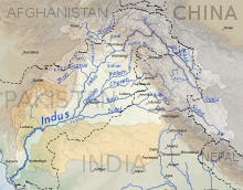
- Indus River
- Panjnad River (in Pakistan)
- Sutlej River (in China, India and Pakistan)
- Spiti River
- Baspa River
- Bhaba River
- Beas River
- Parbati River
- Tirthan River
- Uhl River
- Chenab River (in India and Pakistan)
- Chandra River
- Bhaga River
- Marusudar River
- Tawi River
- Ravi River (in India and Pakistan)
- Budhil River
- Siul River
- Jhelum River (in India and Pakistan)
- Lidder River
- Sind River
- Pohru River
- Neelum or Kishenganga River (in India and Pakistan)
- Poonch River (in India and Pakistan)
- Sutlej River (in China, India and Pakistan)
- Suru River
- Yapola River
- Zanskar River
- Markha River
- Khurna River
- Tsarap River
- Doda River
- Hanley River
- Panjnad River (in Pakistan)
Narmada River Basin
The following rivers are part of the Narmada River's basin:[1][2]
| Tributary | Bank | Source elevation above MSL (m) | Catchment area (km2) | Length (km) |
|---|---|---|---|---|
| Kharmer | Left | - | 557 | 64 |
| Silgi | Right | - | 531 | 65 |
| Burhner | Left | 900 | 4228 | 177 |
| Banjar | Left | 600 | 3282 | 183 |
| Balai | Right | - | 531 | 46 |
| Temur | Left | 550 | 892 | 54 |
| Gaur | Right | 690 | 1107 | 79.5 |
| Saner | Left | - | 581 | 51 |
| Hiran | Right | 500 | 4795 | 188 |
| Sher | Left | 650 | 2903 | 129 |
| Biranjo | Right | - | 1172 | 62 |
| Shakkar | Left | 900 | 2294 | 161 |
| Dudhi | Left | 900 | 1542 | 129 |
| Sukhri | Left | - | 609 | 39 |
| Tendoni | Right | 500 | 1633 | 177 |
| Barna | Right | 450 | 1789 | 105 |
| Tawa | Left | 600 | 6338 | 172 |
| Hather | Left | - | 645 | 37.5 |
| Kolar | Right | 600 | 1348 | 101 |
| Ganjal | Left | 700 | 1931 | 89 |
| Sip | Right | - | 879 | 45 |
| Jamner | Right | 470 | 671 | 30 |
| Chandrakeshar | Right | 600 | 1249 | 30 |
| Ajnal | Left | - | 1203 | 62.5 |
| Machak | Left | 550 | 1112 | 87.5 |
| Chhota Tawa | Left | 400 | 5055 | 169 |
| Khari | Right | - | 754 | 41 |
| Kenar | Right | - | 1581 | 62.5 |
| Kaveri | Left | - | 954 | 32.5 |
| Choral | Right | - | 601 | 55 |
| Kharkia | Left | - | 1099 | 24 |
| Kunda | Left | 900 | 3973 | 130 |
| Karam | Right | - | 858 | 45 |
| Borad | Left | - | 866 | 62.5 |
| Man | Right | 550 | 1529 | 89 |
| Deb | Left | 350 | 969 | 82.5 |
| Uri | Right | - | 2004 | 74 |
| Goi | Left | 800 | 1892 | 129 |
| Hathni | Right | 350 | 1944 | 30 |
| Orsang | Right | 300 | 3946 | 101 |
| Karjan | Left | 200 | 1490 | 93 |
Mahi River Basin
The origin of the river Mahi is Mindha, Madhya Pradesh.
- Mahi River
- Som River
- Gomati River
- Som River
Sabarmati River Basin
- Sabarmati river
- Wakal River
- Sei River
- Harnav River
Tapi River Basin
- Tapi River and its tributaries
- Tapi River (or Tapi) in Maharashtra, Madhya Pradesh and Gujarat
- Gomai River in Nandurbar district of Maharashtra
- Arunavati River in Dhule district of Maharashtra
- Panzara River in Dhule district of Maharashtra
- Kaan River in Dhule district.
- Aner River in Jalgaon, Dhule districts
- Girna River in Nashik, Malegaon, Jalgaon districts
- Titur River in Jalgaon district
- Waghur River in Jalgaon, Aurangabad districts
- Purna River in Amravati, Akola, Buldhana, Jalgaon, Navsari districts of Gujarat, Maharashtra Madhya Pradesh
- Nalganga River in Buldhana district
- Vaan River in Buldhana, Akola, Amravati districts of Maharashtra
- Morna River in Akola, Washim districts
- Katepurna River in Akola, Washim districts
- Umaa River in Akola, Washim districts
- Sangiya River in Amravati district of Maharashtra
Maharashtra Coastal Rivers
- Shastri River
- Gad River
- Vashishti River
- Savitri River
- Kundalika River
- Gandhari River
- Patalganga River
- Ulhas River
- Thane Creek (distributary)
- Vasai Creek (distributary)
- Mithi River or Mahim River
- Oshiwara River
- Dahisar River
- Tansa River in Thane
- Vaitarna River
- Surya River
- Chenna River
- Terna river
Coastal rivers of Goa
Mandovi River, known as Mhadai in Western Ghats of Goa and Karnataka, has three sources: the Degao, the Nanevadichi Nhõi (nhõi means river in Konkani) and Gavali; the last two sources go dry in summer season. The main origin of the river, in the form of a spring, even during Summer season, is at Bavtyacho Dongor hills near Degao village in Khanapur Taluka of Belgaum Dist in Karnataka State.
The three streams confluence at the Kabnali village whereafter it is known as Mhadai, which has an easterly flow initially, then flows north and finally turns to the west on entering Goa. Mhadai River enters Goa between Krisnapur (Karnataka) and Kadval (Goa) villages. The tributaries of the Mhadai are the Nersa Nala, the Chapoli and Kapoli nala, the Bail Nala, the Volo Panshiro ( Karnataka), the Suko Panshiro, the Harparo, the Nanodyachi Nhõi, the Vellsachi Nhõi, the Valpoichi Nhõi, the Ghadghadyachi Nhõi, the Valvanti/ Volvot, the Divcholchi Nhõi, the Asnoddchi Nhõi, the Khandeaparchi Nhõi, the Mhapxechi Nhõi, Xinkerchi Nhõi etc. It is the longest river of Goa with a reported length of 105 km.
Karnataka Coastal Rivers
The rivers flowing through three coastal districts of Karnataka join the Arabian Sea.
- Kali River
- Netravati River
- Sharavathi River
- Aghanashini River
- Gangavalli River
- List of rivers of Dakshina Kannada and Udupi districts
Kerala Coastal Rivers
The rivers flowing through three coastal districts of Kerala to join the Arabian Sea.
- Periyar River
- Bharathapuzha River
- Pamba River
- Chaliyar River
- Chandragiri River
- Karyangod River
Rivers flowing into the inner part of India
- Ghaggar River in Haryana, Rajasthan
- Samir River
- Luni River in Rajasthan
Alphabetical list
This list is incomplete; you can help by adding missing items. (April 2012) |
A - D
- Arvari River
- Aarpa
- Achan Kovil River
- Adyar River
- Manas river, Aganashini
- Agniyar River
- Ahar River
- Ajay River
- Aji River
- Alaknanda River
- Amanat River
- Amaravathi River
- Arkavati River
- Atrai River
- Baga River
- Baitarani River
- Balan River
- Banas River
- Banganga River
- Beas River
- Bhadar River
- Bhima River
- Brahmani River
- Brahmaputra River
- Budha River
- Chaliya River
- Chambal River
- Chapora River
- Chenab river
- Cheyyar river
- Coovum River
- Damanganga River
- Darshan River
- Deo River
- Devi River
- Daya River
- Damodar River
- Doodhna River
- Dhansiri River
- Dudhimati River
- Dravyavati River
E - H
- Falgu River
- Gaangan
- Gadananathi River
- Galgibaga River
- Gambhir River
- Gandak
- Ganges River
- Gayathripuzha
- Ghaggar River
- Ghaghara River
- Ghataprabha
- Girija River
- Girna River
- Godavari River
- Gomti River
- Gosthani River
- Gundlakamma River
- Gunjavni River
- Halali River
- . Hasdev River Chhattisgarh
- Hugli River
- Hindon River
- Hiran River
- Hiranyakeshi River
- Gursuti River
I - L
- IB River
- Indus River
- Indravati River
- Indrayani River
- Jaldhaka
- Jhelum River
- Jayamangali River
- Jambhira River
- Kabini River
- Kadalundi River
- Kaagini River
- Kahn River (also Khan)
- Kali River- Gujarat
- Kali River- Karnataka
- Kali River- Uttarakhand
- Kali River- Uttar Pradesh
- Kali Sindh River
- Kaliasote River
- Karmanasha
- Karban River
- Kallada River
- Kallayi River
- Kalpathipuzha
- Kameng River
- Kanhan River
- Kamla River
- Kannadipuzha
- Karnaphuli River
- Kaveri River
- Kelna River
- Kathajodi River
- Kelo River
- Khadakpurna River
- Kodoor River
- Koel River
- Kolab River
- Kolar River (Madhya Pradesh)
- Kolar River (Maharashtra)
- Kollidam River
- Kosi River
- Kuakhai River
- Koyna River
- Krishna River
- Kundali River
- Kaushiga River
- Kuwanav River
- Kshipra River
- Ken River
- Karha River
- Lachen River
- Lachung River
- Lakshmana Tirtha River
- Luni River
- Kayadhu River (starts near Agarwadi in Risod Taluka in Washim district and meets Penganga near Sangam Chincholi)
- Kham River, Aurangabad Maharashtra
M - P
- Machchhu River
- Madira Puja
- Mahanadi River
- Mahananda River
- Mahakali River
- Mahi River
- Manas river.
- Mandovi River
- Manjira River
- Manu River, Tripura
- Mapusa River
- Markanda River, Haryana
- Markanda River, Tamil Nadu
- Markhandeya River, Karnataka
- Marutsudha River
- Mayurakshi River
- Meenachil River
- Meghna River
- Mithi River
- Mudangiyar River
- Mula River
- Musi River
- Mutha River
- Muvattupuzha River
- Malaprabha
- Mani River
- Manimala River
- Manorama River
- Matla River
- Moyar River
- Narava Gedda
- Narmada River
- Nethravathi River
- Nag River
- Nagavali River
- Nirguda River
- Nubra River
- Padma River
- Palar River
- Pamba River
- Pahuj River
- Pavana River
- Penganga River
- Man River
- Mandakini River (Uttarakhand)
- Pallikkal Aaru River
- Panchganga River
- Panjnad River
- Panzara River
- Parambikulam River
- Parbati River (Himachal Pradesh)
- Parbati River (Madhya Pradesh)
- Parbati River (Rajasthan)
- Payaswini
- Penna River
- Pench River
- Penganga River
- Penner River
- Periyar River
- Phalgu
- Pluest River (Poonch J&K)
- Ponnaiyar River
- Pranhita River
- Punarbhaba River
- Purna River (tributary of Godavari)
- Purna River (tributary of Tapti)
Q - T
- Ravi river
- Rapti River
- Rupnarayan River
- Sahibi River (Rajasthan)
- Saraswati River (MP)
- Sarasvati River (dried up, now under revival)
- Sarayu
- Sutlej River
- Suvarnamukhi River
- Sabarmati River
- Sal River
- Shalmali River near Sode
- Shivnath River Chhattisgarh
- Sirsi, Karnataka
- Sharavati River
- Sengar River
- Shetrunji River
- Son River
- Sharda River
- Shimsha River (Karnataka)
- Shyok River
- Subarnarekha River
- Talpona River
- Tapi River
- Thamirabarani River
- Tangri River
- Thate Puthra River
- Tungabhadra River
- Tamsa River
- Tunga river
- Terekhol River
U - W
- Vaan River
- Vaigai River
- Vamsadhara River
- Varuna River
- Vashishti River
- Vedavathi River
- Vellar River (Northern Tamil Nadu)
- Vellar River (Southern Tamil Nadu)
- Vrishabhavathi River
- Vishwamitri River
- Vaitarna
- Udyavara River
- Ulhas River
- Uttara Cauvery River
- Wainganga River
- Wagh River
- Wardha River
- Wehashli River
X - Z
- Yagachi River (Karnataka)
- Yamuna River
- Zuari River
See also
- Indian rivers interlinking project
- Irrigation in India
- List of dams and reservoirs in India
- List of rivers in India by discharge
- List of National Waterways in India
- Major rivers of India
- RORO ferries in India
- Sagar Mala project
References
- Integrated Water Year Book - Narmada Basin (June 2015-May 2016) Archived 2017-08-22 at the Wayback Machine, p. 9-10. Published by Central Water Commission, Narmada Basin Organization in April 2017.
- K. Sankaran Unni (1996). Ecology of River Narmada. APH. pp. 16–17. ISBN 978-81-7024-765-4.
Further reading
- Bhalerao, S.M., Encyclopedia of Indian Rivers (in English)
- Vol. 1: Scientific Information, pages 1–836 (ISBN 978-93-86401-66-3)
- Vol. 2: Scientific Information, pages 837-1760 (ISBN 978-93-86401-66-3)
- Vol. 3: Scientific, Cultural, Historical Information, pages 1760-2308 (ISBN 978-93-86401-66-3)
- Vol. 4: Book of 60 Maps (ISBN 978-93-86401-66-3)
- Year of publication: 2019, Diamond Publications, Pune 411030, India (www.diamondbookspune.com)
- Bhalerao, S.M., Bharatiya Sarita Kosh (in Marathi), (Encyclopedia of Indian Rivers)
- Vol. 1: Scientific Information, pages 1–788 (ISBN 978-81-89959-50-0)
- Vol. 2: Scientific Information, pages 789-1660 (ISBN 978-81-89959-51-7)
- Vol. 3: Scientific, Cultural, Historical Information, pages 1661-2468 (ISBN 978-81-89959-52-4)
- Vol. 4: Book of 60 Maps (ISBN 978-81-89959-57-9)
- Year of publication 2007, Diamond Publications, Pune 411030, India (www.diamondbookspune.com)
External links
- "India Water resources". Aquastat. FAO. 2016.
- "Ganges-Brahmaputra-Meghna river basin". Irrigation in Southern and Eastern Asia in figures – AQUASTAT Survey. FAO. 2011.
- yamuna mission
| Sovereign states |
|
|---|---|
| States with limited recognition |
|
| Dependencies and other territories |
|
| |
На других языках
- [en] List of rivers of India
[es] Anexo:Ríos de India
Este artículo trata sobre los ríos más largos de India y quiere recoger, en todos los ríos forma de tabla, todos los ríos y afluentes principales de más de 300 km de longitud. Se listan aquí los cursos de agua según el criterio hidrográfico habitual, esto es, determinando la longitud de un río por la longitud de su fuente más alejada, con independencia de que dicho río conserve en todo su recorrido el nombre. Esto es especialmente problemático en India, ya que habitualmente los ríos cambian de nombre al confluir afluentes importantes. En esos casos se hace la advertencia, utilizando la notación «sistema» para referirse al sistema fluvial conjunto de los ríos considerados (por ejemplo, el río Meghna corresponde al sistema fluvial de los ríos Ganges-Brahmaputra-Meghna). La mayoría de Atlas y Anuarios elaboran listados sobre los ríos más largos en que se suelen listar considerando solamente, salvo en los casos de los ríos más conocidos.Другой контент может иметь иную лицензию. Перед использованием материалов сайта WikiSort.org внимательно изучите правила лицензирования конкретных элементов наполнения сайта.
WikiSort.org - проект по пересортировке и дополнению контента Википедии