geo.wikisort.org - River
The Suru River[needs IPA] is a tributary of the Indus River that flows largely through the Kargil district of Ladakh, India. The Suru Valley is coextensive with the Kargil tehsil, with the town of Kargil situated on its banks. The river enters the Skardu District of Pakistani-administered Gilgit-Baltistan, coursing a brief length before joining the Indus at Nurla.[1]
| Suru River | |
|---|---|
 Suru River passing through the town of Kargil | |
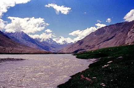
 Course of the Suru | |
| Location | |
| Country | India, Pakistan |
| Territory | Ladakh (India), Gilgit-Baltistan (Pakistan) |
| District | Kargil (India), Skardu (Pakistan) |
| Physical characteristics | |
| Source | 33.832917°N 76.21861°E |
| • location | Panzella glacier, Pensi La Kargil, India |
| • elevation | 4,555 m (14,944 ft) |
| Mouth | 34.746134°N 76.215927°E |
• location | Indus River at Nurla, Marol, Skardu, Pakistan |
• elevation | 2,528 m (8,294 ft) |
| Length | 185 km (115 mi) |
| Discharge | |
| • average | 385 m3/s (13,600 cu ft/s) |
Geography
The Suru River is a 185 kilometres (115 mi) long river, that originates from the Panzella glacier which lies at Pensi La pass near the Drang Drung Glacier. The Drang Drung Glacier also gives rise to the Stod River which flows down in the opposite direction from the Suru. The source of the Suru River lies 142 kilometres (88 mi) south of Kargil town, and 79 kilometres (49 mi) north from Zanskar. Srinagar, the capital of Jammu and Kashmir lies 331 kilometres (206 mi) to the west.[citation needed] The Suru River forms the western and northern boundary of the Zanskar Range.[2] The river flows westwards, along with the Kargil-Zanaskar Road, from its source and forms the Suru valley, which is towered by the massif of Nun Kun mountain. It drains the Nun Kun mountain massif of the Zanskar Range in the Suru valley, and is joined by a tributary "Shafat Nala" at the pastures of Gulmatango. This stream originates from the Shafat Glacier.[3] The Suru River then flows northwards through a deep, narrow gorge to Kargil town, where it is fed by the Botkul River which originates from the glacier of the same name.[1] The Dras River, fed by the Shingo River, joins the Suru River at Kharul, 7 kilometres (4.3 mi) north of Kargil town.[4] The Suru River then enters the Pakistani Administered Kashmir 5 kilometres (3.1 mi) ahead from the point of merger of Dras and Suru rivers through Post 43 and Post 44 of India and Pakistan respectively and merges with the Indus River at Nurla.[1][2]

Most part of the river flows within the jurisdiction of Kargil district. It flows through the towns of Tongul, Suru, Grantung, Goma and Kharul. Kargil town is the largest city situated on the banks of the Suru River, also being the second largest city in the Ladakh region after Leh. A branch of the anicient Silk Road ran alongside the Suru River, connecting Kargil and Skardu. The road is now closed due to the Line of Control.[5][6]
The Suru River has extensive possibilities for rafting and it is practised during the summer. The Suru Valley is the starting point for rafting trips, and it also provides a base for mountaineering expeditions to the Nun Kun mountain massif.[7]
Agriculture in Ladakh is scarce due to the dry climate, and is restricted to the river valleys. The Suru valley, formed by the catchment of the Suru River, receives irrigation through the canals of the Suru River. The main crops grown in the valley include barley, buckwheat, turnips and mustard.[8]
References
- S. S. Negi (2002). Cold Deserts of India. Indus Publishing, 2002. p. -13. ISBN 9788173871276. Retrieved 28 August 2012.
- "Rivers of Ladakh". ladakh.com. Archived from the original on 2 September 2012. Retrieved 29 August 2012.
- Prem Singh Jina (1996). Ladakh: The Land and the People. Indus Publishing, 1996. p. -16. ISBN 9788173870576. Retrieved 29 August 2012.
{{cite book}}: CS1 maint: uses authors parameter (link) - Omacanda Hāṇḍā (2001). Buddhist Western Himalaya: A politico-religious history. Indus Publishing, 2001. p. -67. ISBN 9788173871245. Retrieved 27 August 2012.
- "Kargil the Suru valley". gaffarkashmir.com. Retrieved 29 August 2012.
- Sanjeev Kumar Bhasin (2006). Amazing Land Ladakh: Places, People, and Culture. Indus Publishing, 2006. p. -28. ISBN 9788173871863. Retrieved 28 August 2012.
- Yogendra Bali, R. S. Somi (2005). Incredible Himalayas: Environment, Culture, Tourism, and Adventure. Indus Publishing, 2005. p. -143. ISBN 9788173871795. Retrieved 29 August 2012.
{{cite book}}: CS1 maint: uses authors parameter (link) - Indu Ramchandani (2000). Students' Britannica India, Volumes 1-5. Popular Prakashan, 2000. p. -126. ISBN 9780852297605. Retrieved 29 August 2012.
External links
![]() Media related to Suru River at Wikimedia Commons
Media related to Suru River at Wikimedia Commons
Capital: Kargil; Leh | |||||||||||||||||||
| State symbols |
| ||||||||||||||||||
| History |
| ||||||||||||||||||
| Administration |
| ||||||||||||||||||
| Geography |
| ||||||||||||||||||
| Human settlements | |||||||||||||||||||
| Culture |
| ||||||||||||||||||
| Tourism and wildlife |
| ||||||||||||||||||
| Transport |
| ||||||||||||||||||
| Infrastructure |
| ||||||||||||||||||
| See also |
| ||||||||||||||||||
На других языках
[de] Suru
Der Suru ist ein linker Nebenfluss des Indus im indischen Unionsterritorium Ladakh und in Gilgit-Baltistan (Pakistan).- [en] Suru River (Indus)
[ru] Суру (приток Шинго)
Суру[1] (Карча-Нар[2], в верховье Сангпо[2]) — река в Ладакхе. Впадает в Шинго[1][2] (приток Инда) справа, в 5 км выше Каргила.Другой контент может иметь иную лицензию. Перед использованием материалов сайта WikiSort.org внимательно изучите правила лицензирования конкретных элементов наполнения сайта.
WikiSort.org - проект по пересортировке и дополнению контента Википедии