geo.wikisort.org - Mountains
K12 is the second highest peak in the Saltoro Mountains, a subrange of the Karakoram range in the Siachen region of Ladakh. Its name comes from its designation given during the original survey of the Karakoram range. In 1984, an Indian army expedition under Colonel Prem Chand took hold of this peak, from the side of Siachen glacier by traversing from the west.[2]
| K12 | |
|---|---|
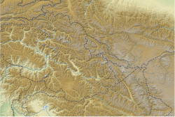 K12 Saltoro Ridge, Siachen, Actual Ground Position Line  K12 K12 (Ladakh)  K12 K12 (Gilgit Baltistan) | |
| Highest point | |
| Elevation | 7,428 m (24,370 ft)[1] Ranked 61st |
| Prominence | 1,978 m (6,490 ft)[1] |
| Listing | Ultra |
| Coordinates | 35°17′42″N 77°01′18″E [1] |
| Geography | |
| Location | Saltoro Ridge, Siachen, Actual Ground Position Line |
| Parent range | Saltoro Mountains, Karakoram |
| Climbing | |
| First ascent | 1974 by Shinichi Takagi, Tsutomu Ito (Japanese) |
| Easiest route | snow/ice climb |
K12 lies to the southwest of the Siachen Glacier; the K12 glacier heads on its northeast slopes and feeds the Siachen. The western slopes of K12 drain to the Bilafond Glacier system, and thence to the Dansam River, and eventually the Indus River.
K12 had been used as the objective for training Indian Army Mount Everest expedition in 1985.[3] Apart from this, K12 has seen little climbing activity, partly because of the unsettled political situation and the continued military presence in the area. It was first attempted in 1960, after a reconnaissance visit by famed explorer Eric Shipton in 1957. After a further unsuccessful attempt by a Japanese party in 1971, another Japanese expedition put two climbers, Shinichi Takagi and Tsutomu Ito, on the summit. They fell and died on the descent, and their bodies were not recovered. Another Japanese expedition returned in 1975 and made the second ascent.
See also
- List of Ultras of the Western Himalayas
- Siachen conflict
- Actual Ground Position Line
- Indira Col
- Sia La
- Ghent Kangri
- Saltoro Kangri
- Bilafond La
- Chumik Glacier
- Gyong La
- NJ9842
References
- "High Asia I: The Karakoram, Pakistan Himalaya and India Himalaya (north of Nepal)". Peaklist.org. Retrieved 2014-05-27.
- Kapadia, Harish (1999). Across Peaks & Passes in Ladakh, Zanskar & East Karakoram. ISBN 9788173871009.
- "ASCENT OF K12 (7428 m) IN SALTORO HILLS (RANGE) : Himalayan Journal vol.41/15". www.himalayanclub.org. Retrieved 2020-06-15.
Sources
- Jerzy Wala, Orographical Sketch Map of the Karakoram, Swiss Foundation for Alpine Research, 1990.
- Jill Neate, High Asia: an illustrated history of the 7,000 metre peaks, The Mountaineers, 1989.
На других языках
[de] K12 (Berg)
Der K12 ist die zweithöchste Erhebung in den Saltoro-Bergen, einem Teilgebirge des Karakorumgebirges im indisch kontrollierten Gebiet.- [en] K12 (mountain)
[es] K12
El K12, con 7.428 msnm,[1] es la segunda montaña más alta de las montañas Saltoro, una sección de la gran Cordillera del Karakórum que se encuentra en la región de Siachen, cerca de Gilgit-Baltistán.[1] Está situada muy cerca de la Línea de control que separa las zonas controladas por los ejércitos indio y pakistaní en Cachemira. El nombre se le dio durante la primera exploración del Karakórum, en época colonial, cuando en el año 1856 un equipo topográfico europeo dirigido por el británico Henry Haversham Godwin-Austen visitó la zona.[fr] K12 (montagne)
Le K12 est un sommet situé dans la chaîne du Karakoram, dans une région revendiquée par le Pakistan et l'Inde.[ru] К12
K12 (7428 м[1]) — вторая по величине вершина хребта Салторо[en], Каракорум, в индийском районе Сиачен вблизи Линии контроля с Пакистаном[2].Другой контент может иметь иную лицензию. Перед использованием материалов сайта WikiSort.org внимательно изучите правила лицензирования конкретных элементов наполнения сайта.
WikiSort.org - проект по пересортировке и дополнению контента Википедии