geo.wikisort.org - Mountains
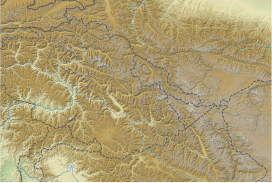
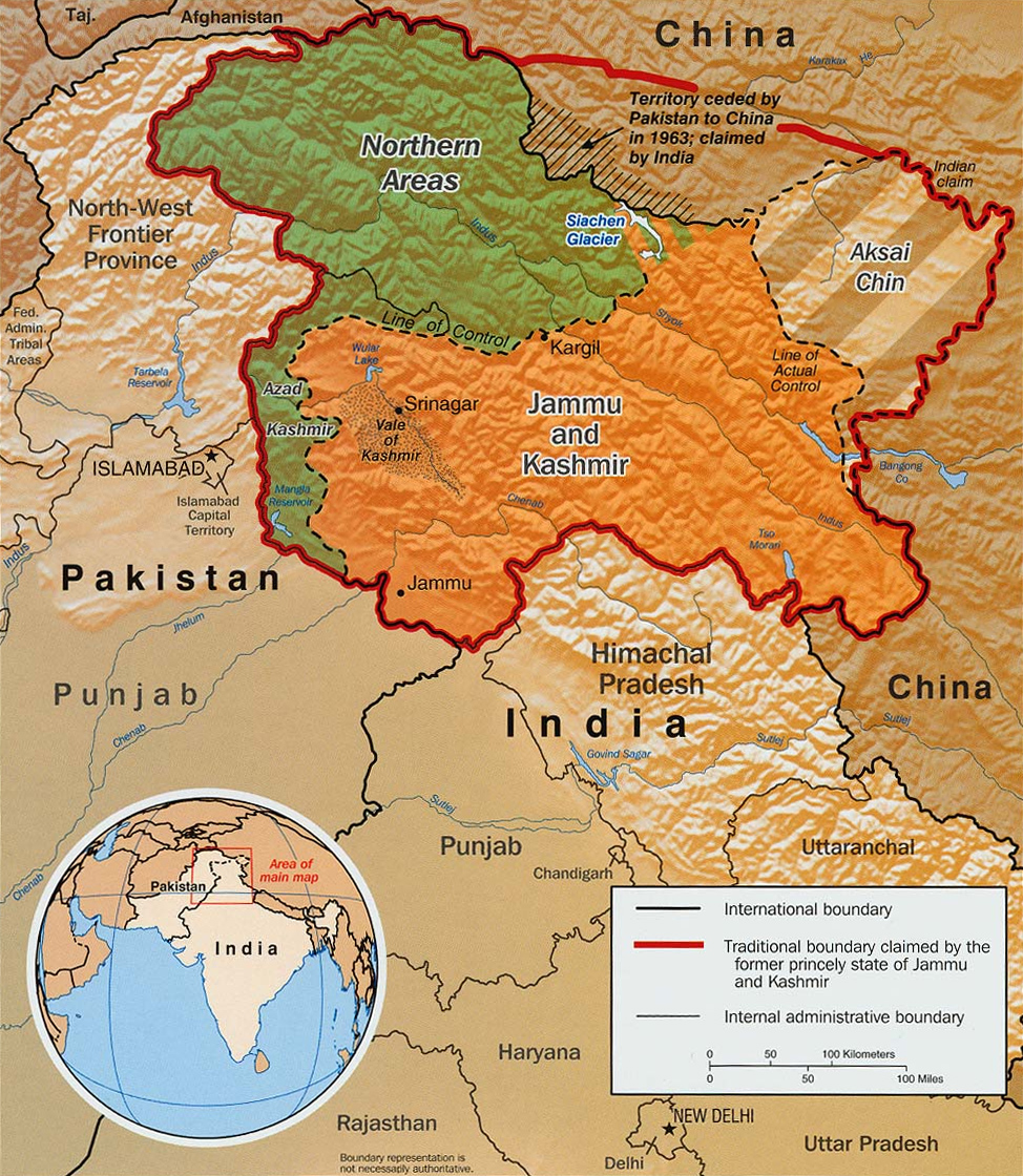
Ghent Kangri (or Mount Ghent, Ghaint I) is a high peak near the north end of the Saltoro Mountains, a subrange of the Karakoram range. It is located west of the Siachen Glacier near the Actual Ground Position Line in Pakistan between India and Pakistan.
| Ghent Kangri | |
|---|---|
| Mount Ghent | |
| Highest point | |
| Elevation | 7,401 m (24,281 ft) Ranked 69th |
| Prominence | 1,493 m (4,898 ft) |
| Coordinates | 35°31′39″N 76°48′39″E |
| Geography | |
| Location | Saltoro Ridge, Siachen, near the Actual Ground Position Line (the line between Indian and Pakistan controlled territories)[1][4][3] |
| Parent range | Saltoro Mountains, Karakoram |
| Climbing | |
| First ascent | 1961 by Wolfgang Axt (Austrian) |
| Easiest route | West Ridge: glacier/snow climb |
 | |


| Ghent Kangri | |||
|---|---|---|---|
| Simplified Chinese | 根特崗日峰 | ||
| |||
Ghent Kangri was first climbed on 4 June 1961, by Wolfgang Axt, a member of an Austrian expedition led by Erich Waschak, via the West Ridge. He climbed solo above the high camp.
According to the Himalayan Index, there have been three subsequent ascents of the peak, in 1977, 1980, and 1984.

See also
- Near the AGPL (Actual Ground Position Line)
- NJ9842, LoC ends and AGPL begins
- Gyong La
- Chumik Glacier
- Saltoro Mountains
- Saltoro Kangri
- Bilafond La
- Sia La
- Indira Col, AGPL ends at LAC
- Borders
- Actual Ground Position Line (AGPL)
- India–Pakistan International Border {IB)
- Line of Control {LoC)
- Line of Actual Control (LAC)
- Sir Creek (SC)
- Borders of China
- Borders of India
- Borders of Pakistan
- Conflicts
- Kashmir conflict
- Siachen conflict
- Sino-Indian conflict
- List of disputed territories of China
- List of disputed territories of India
- List of disputed territories of Pakistan
- Northern Areas
- Trans-Karakoram Tract
- Operations
- Operation Meghdoot, by India
- Operation Rajiv, by India
- Operation Safed Sagar, by India
- Other related topics
- Awards and decorations of the Indian Armed Forces
- Bana Singh, after whom Quaid Post was renamed to Bana Top
- Dafdar, westernmost town in Trans-Karakoram Tract
- India-China Border Roads
- Sino-Pakistan Agreement for transfer of Trans-Karakoram Tract to China
References
- The Future of Kashmir on the BBC website.
- Peak Ghent Kangri, Diskit Nubra, Leh District, Ladakh, India, OpenStreetMap, retrieved 30 May 2020.
- "Ghent Kangri, Pakistan/India". Peakbagger.com. Retrieved 29 December 2020.
- Peak Ghent Kangri, Diskit Nubra, Leh District, Ladakh, India, OpenStreetMap, retrieved 30 May 2020.
Sources
- Neate, Jill (1989). High Asia: an illustrated history of the 7,000 metre peaks. The Mountaineers.
- Jerzy Wala, Orographical Sketch Map of the Karakoram, Swiss Foundation for Alpine Research, 1990.
This Pakistan location article is a stub. You can help Wikipedia by expanding it. |
This Indian location article is a stub. You can help Wikipedia by expanding it. |
This Ladakh, India location article is a stub. You can help Wikipedia by expanding it. |
На других языках
[de] Ghent Kangri
Der Ghent Kangri (oder Mount Ghent, Ghaint I) ist ein 7401 m hoher Berg am nördlichen Ende der Saltoro-Berge, einem Gebirgszug im Karakorum.- [en] Ghent Kangri
[es] Ghent Kangri
El Ghent Kangri, o Mount Ghent, Ghaint y, es con 7.401 msnm, la tercera montaña más alta de las montañas Saltoro, una sección de la gran cordillera del Karakórum que se encuentra en la región de Siachen, cerca de Gilgit-Baltistán.[1] Se encuentra muy cerca de la línea de control que separa las zonas controladas por los ejércitos indio y pakistaní en Cachemira.[2][fr] Ghent Kangri
Le Ghent Kangri est une montagne située dans une zone revendiquée par l'Inde et le Pakistan. Il culmine à 7 401 mètres d'altitude et se situe dans les monts Saltoro dans la chaîne du Karakoram[1].Другой контент может иметь иную лицензию. Перед использованием материалов сайта WikiSort.org внимательно изучите правила лицензирования конкретных элементов наполнения сайта.
WikiSort.org - проект по пересортировке и дополнению контента Википедии