geo.wikisort.org - River
The Neelum River, or Kishanganga, is a river in the Kashmir region of India and Pakistan. It originates in the north of Indian Jammu and Kashmir, flows through the Neelam District of Pakistan's Azad Kashmir and then merges with the Jhelum River near the city of Muzaffarabad.[1]
| Neelum River Kishanganga | |
|---|---|
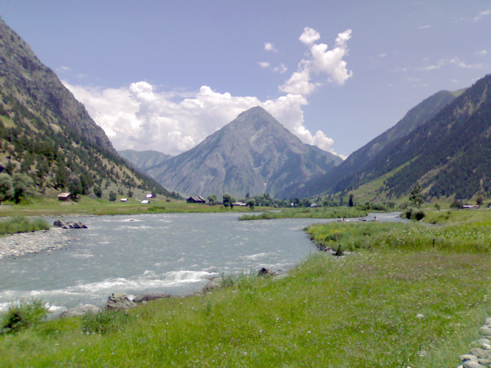
 Neelum River passing from Dosut, Neelum Valley | |
| Native name | دریائے نیلم (Urdu) |
| Location | |
| Country | India, Pakistan |
| Region | Kashmir |
| Physical characteristics | |
| Source | 34.389629°N 75.121806°E |
| • location | Krishansar Lake at Sonamarg |
| • elevation | 3,710 m (12,170 ft) |
| Mouth | 34.354869°N 73.468537°E |
• location | Jhelum River at Muzaffarabad, Pakistan |
• elevation | 750 m (2,460 ft) |
| Length | 245 km (152 mi) |
| Discharge | |
| • location | Muzzafarabad |
| • average | 465 m3/s (16,400 cu ft/s) |
| Basin features | |
| Progression | Jhelum River |
| River system | Indus River |
| Tributaries | |
| • left | Sind River, Lidder River |
Name of the river
The river has traditionally been known as the Kishanganga River (Urdu: دریائے کِشن گنگا) and is still known as such in India; after the partition of India in 1947, the river was renamed the Neelum River (دریائے نیلم) in Pakistan in 1956.[2][3][4]
Basin
Shardadesh is a name for the drainage basin of the Kishanganga River.[citation needed]
Course
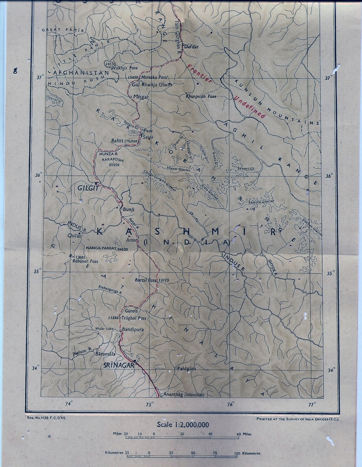
The Kishanganga River originates from Krishansar Lake[5] in the vicinity of Sonamarg in the Indian union territory of Jammu and Kashmir, and runs northwards to Badoab village in Tulail Valley where it meets a tributary from the Dras side. Then it runs westwards, parallel to the Kashmir Line of Control. It is fed by many glacial tributary streams on its way. It enters Pakistani self-governing territory of Azad Kashmir in the Gurez sector of the Line of Control. Then it again runs west, parallel to the Line of Control, passing by Sharada. After Sharda, it bends to a southwesterly direction and runs along the Line of Control near Tithwal. Then it bends northwest again, making a wide arc to join the Jhelum River in Muzaffarabad.[6][7].Recently the Go Gurez campaign has been launched to make people aware of the area.
Valleys

The Kishanganga River is 245 kilometres long. It covers 50 kilometers in the Indian-administered Kashmir where it flows through the Tulail Valley and then Gurez Valley. It covers the remaining 195 kilometres in Pakistan-administered Kashmir and flows through the. From its origin it flows through the Neelam Valley.
The Neelum Valley is a Himalayan gorge in the Kashmir region, along which the Neelum River flows. This green and fertile valley is 250 km in length and stretches its way from Muzaffarabad all the way to Athmuqam and beyond to Taobutt. It is one of the most attractive tourists places, like Swat and Chitral, but due to poor road system is yet veiled to the outside world. This area was badly affected by the 2005 earthquake and was cut off from the outside world as the roads and paths were filled with rubble. Now construction of an international standard road is in progress. There are two entrances for Neelum valley, one Neelum Road by Muzaffarabad and the other by Kaghan the Jalkhad Road. Generally Neelum valley starts just after Muzaffarabad but in political division the area from Muzaffarabad to Chelhana is named Kotla valley. District Neelum starts from Chelhana and goes up to Taobutt.
Ecology
Revival of fish species
There are different kinds of fish found in abundance in the Neelum River. As the river almost entirely runs across the Line of Control, being the main cause for Kashmir conflict there is a feeling of uncertainty among the inhabitants, many of them have emigrated[8] to safer places, which has left the river banks scarcely populous and kept the river in perfect conditions for growth of fish. The most famous among the different variety of fish found in Neelum River are:[9]
- Brown trout (Salmo trutta)
- Rainbow trout (Oncorhynchus mykiss)
- Snow trout (Schizothorax plagiostomus)
- Shuddgurn
- Anyour
Dams
Kishanganga dam in India
In the Indian union territory of Jammu and Kashmir, the construction work on the 330 MW Kishanganga Hydroelectric Plant project has started, after being defunct for eighteen years.[10][11] Recently, the project was awarded to Hindustan Construction Company (HCC) with a timeline of seven years. The 330 MW Kishanganga hydro-electric power project involves damming of the Kishanganga River and the proposed 37 metre reservoir will submerge some parts of the Gurez valley.[12] The water of Kishen Ganga River will be diverted through a 24 kilometre tunnel dug through the mountains to Bandipore where it will join the Wular Lake and then Jhelum River.[12]
Neelum–Jhelum dam in Pakistan
Similarly, Pakistan is constructing the 969 MW Neelum–Jhelum Hydropower Plant; the country has placed the project in the hands of a Chinese consortium.[10] Pakistan claims that the Indian dam project will violate the Indus Waters Treaty and has pursued formal arbitration proceedings against India over the matter.[13][14]
Religious significance
Krishansar Lake and Sharada Peeth are important religious site for Hindus, who undertake the annual pilgrimage to these sites along the Kishanganga River. In the ancient times it was among the prominent centre of learning in the subcontinent in part with Nalanda and Taxila. Sharada script the - native script for the Kashmiri language is named in the honor of main deity of Sharada Peeth. Sharada Peeth is one of the most venerated site for the Kashmiri Pandits. Sharada Peeth temple was damaged in the 2005 Kashmir earthquake. the Supreme Court of Pakistan ordered the Government to conserve the Sharada Peeth temple and the govt to identify and restore temples and gurudwaras.[15] The "Save Sharada Committee" of concerned Hindus has been demanding the opening of special corridor from India to Sharada Peeth in Pakistan-administered Kashmir for the visits of Hindu pilgrims from India.[16]
See also
- Karen Village
References
- Banerji, Arindam (20 June 2003). "The Neelam Plan". Rediff. Retrieved 15 August 2016.
The Neelam River enters Pakistan from India in the Gurais sector of the Line of Control, and then runs west till it meets the Jhelum north of Muzzafarabad.
- Lavoy, Peter R. (12 November 2009). Asymmetric Warfare in South Asia: The Causes and Consequences of the Kargil Conflict. Cambridge University Press. p. 56. ISBN 978-1-139-48282-0.
Neelum Valley refers to the river called Kishanganga (Indian maps) and renamed Neelum as it flows into Pakistani-administered Kashmir where it subsequently joins the River Jhelum near Muzaffarabad.
- Dewan, Parvez (2004). Parvéz Dewân's Jammû, Kashmîr, and Ladâkh: Kashmîr. Manas Publications. p. 277. ISBN 978-81-7049-179-8.
- Naqvi, Mubashar (28 July 2017). "Charms of the Neelum valley". The Friday Times. Retrieved 30 August 2021.
Before Partition in 1947, this region was known as Drawah. The Azad Jammu and Kashmir government, in 1956, held a cabinet meeting to rechristen the River Kishanganga as the River Neelum and the Drawah region as Neelum Valley. These new names were proposed to the cabinet by war veteran Syed Mohammad Amin. With the approval of the AJK Cabinet, the changes in name took place.
- Majid Hussain (1998). Geography of Jammu and Kashmir. Rajesh Publications, 1998. p. 13–. ISBN 9788185891163. Retrieved 31 July 2012.
- "The Neelam Plan". Rediff. Retrieved 15 November 2009.
- "Basic Facts about the Kishenganga Dam ProjectK". Kashmir Environmental Watch Association. Archived from the original on 31 August 2010. Retrieved 15 November 2009.
- "Kashmiri refugees: facts issues and the future ahead". ips.org.pk. Archived from the original on 24 August 2011. Retrieved 21 February 2012.
- "Gippsland Aquaculture Industry Network-Gain". growfish.com.au. Archived from the original on 20 February 2012. Retrieved 22 February 2012.
- "Kishen Ganga power project to be revived". The Hindu. Chennai, India. 22 April 2008. Archived from the original on 6 November 2012. Retrieved 15 November 2009.
- "Welcome to Kishenganga valley Project". NHPC Limited. Retrieved 20 December 2011.
- "Kishen Ganga project to begin soon". The Indian Express. Archived from the original on 1 October 2012. Retrieved 15 November 2009.
- Pakistan Seeks Resolution of India Water Dispute. By TOM WRIGHT in Lahore, Pakistan, and AMOL SHARMA in New Delhi. Wall Street Journal. 20 May 2010.
- "Hague Court asks India to stop Kishanganga project". The International News. 25 September 2011. Retrieved 20 December 2011.
- For the first time in 72 years, Indian Hindu couple performs puja at Sharada Peeth in PoK, DNA (newspaper).
- Supreme Court in PoK intervenes to save Sharda temple, DNA (newspaper).
External links
- The course of the Neelum River plotted on OpenStreetMap: part 1, part 2, part 3, part 4, part 5, part 6
- Neelum Valley.zoomshare
- Neelum Valley Official
Kashmir Valley | ||
|---|---|---|
| Passes |
|  |
| Valleys |
| |
| Cities | ||
| Towns |
| |
| Rivers | ||
| Glaciers |
| |
| Lakes | ||
| Mountains | ||
| Hill stations and Mughal gardens | ||
| Protected Areas |
| |
| See also |
| |
| Authority control: National libraries |
|---|
На других языках
[de] Nilam
Der Nilam (englisch Neelum bzw. Neelam) ist ein rechter Nebenfluss des Jhelam im indischen Unionsterritorium Jammu und Kashmir und im pakistanischen teilautonomen Gebiet Asad Kaschmir.- [en] Neelum River
[es] Río Neelum
El río Neelum ( en hindi, नीलम नदी ) o Kishanganga ( en hindi, कृष्णगंगा नदी ), es un río en la región de Cachemira de India y Pakistán; comienza en la ciudad india de Gurais y luego se fusiona con el río Jhelum cerca de la ciudad paquistaní de Muzaffarabad .[1]Другой контент может иметь иную лицензию. Перед использованием материалов сайта WikiSort.org внимательно изучите правила лицензирования конкретных элементов наполнения сайта.
WikiSort.org - проект по пересортировке и дополнению контента Википедии