geo.wikisort.org - Mountains
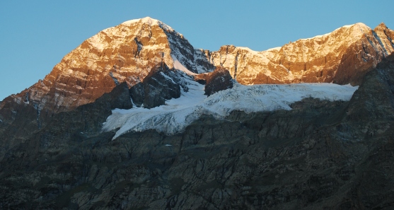
Mt Harmukh (originally "Haramukuta") is a mountain with a peak elevation[3] of 5,142 metres (16,870 ft), in Ganderbal district of Jammu and Kashmir in India. Harmukh is part of the Himalaya Range and is located between Sind River in the south and Kishanganga River in the north, rising above Gangabal Lake[4] in the vicinity of Kashmir valley. It is mostly climbed from the northwestern side of Erin, Kodara, Bandipore.[2] Harmukh is considered sacred in Hinduism.
| Harmukh | |
|---|---|
 Harmukh | |
| Highest point | |
| Elevation | 5,142 m (16,870 ft)[1] |
| Prominence | 1,462 m (4,797 ft)[1] |
| Coordinates | 34°24′00″N 74°54′30″E[1] |
| Geography | |
 Harmukh Harmukh on a map of Jammu and Kashmir, India  Harmukh Harmukh (India) | |
| Location | Ganderbal, Jammu and Kashmir, India |
| Parent range | Himalayas |
| Climbing | |
| First ascent | 1899 by Dr Ernest Neve and Geoffrey Millais, United Kingdom[2] |
| Easiest route | Erin, Bandipore |
Etymology
Harmukh derives from Haramukuta, meaning "the diadem of Hara (Shiva)".
The entire region of Harmukh is also known as Ramaradhan, as it is believed that Parashurama had meditated near lakes on this mountain range.[5]
Religious beliefs
Harmukh, with Gangbal Lake at its foot, is considered a sacred mountain by Hindus. It is also known as 'Kailash of Kashmir'[6] According to the legend of "Hurmukhuk Gosoni",[7] once a hermit tried to reach the summit of Harmukh to see Shiva face to face. For twelve long years, he tried to scale the summit but failed until one day he saw a Gujar descending the summit. When the Gujar approached him, the hermit enquired as to what he had seen there. The Gujar said he had been searching for a stray goat, and that while searching he saw a couple milking a cow and drinking the milk from a human skull. The couple had offered him some milk, which he refused to drink; when they departed they rubbed a little of the milk on his forehead. When the Gujar indicated the spot where the milk was rubbed, the hermit was extremely joyful and rushed to lick his forehead.
Harmukh Gangbal Yatra
This pilgrimage takes place every year on the eve of Ganga Ashtami. The yatris begin their yatra from Naranag.[8]
Geographical setting
Harmukh lies in the northwestern Himalayan Range. The Kashmir Valley lies to its south. Water from melting glaciers form Gangabal Lake which lies at its foot to the north east side and contribute significantly to the regional fresh-water supply, supporting irrigation through Sind River. It is notable for its local relief as it is a consistently steep pyramid, dropping sharply to the east and south, with the eastern slope the steepest.
Climbing history
Harmukh mountain massif has several summits, the Station Peak being the lowest with a peak elevation of 4,698 metres (15,413 ft) was first climbed by members of the Great Trigonometric Survey of British India led by Thomas Montgomerie in 1856. Montgomerie made the first survey of the Karakoram range which lies some 210 km (130 miles) to the north from here and sketched the two most prominent peaks, labeling them K1 (also called Masherbrum) and K2, which is the world's second-highest mountain.[9][10] The highest eastern peak 5,142 metres (16,870 ft) was summited by Dr Ernest Neve and Geoffrey Millais in 1899.[2] The mountain has since become popular among climbers and mountaineers.
Climbing routes
The easiest route among the different routes of Harmukh is via Erin, Bandipore,[11] 47 km motorable road from Srinagar to Erin and 18 kilometers of high altitude alpine trek leads to the base of Harmukh. Another trek leads from Naranag[12] to the base of Harmukh at Gangabal Lake, but it is a steep climb at some places.[13]
References
- "The Karakoram, Pakistan Himalaya and India Himalaya (north of Nepal) - 68 Mountain Summits with Prominence of 1,500 meters or greater". Peaklist.org. Retrieved 3 May 2013.
- "The HJ/12/10 MEMORIES OF EARLY KASHMIR CLIMBING". The HJ/12/10 MEMORIES OF EARLY KASHMIR CLIMBING. Retrieved 22 March 2022.
- "How high is Harmukh". wolframalpha.com. Retrieved 24 April 2012.[permanent dead link]
- "Geography of Kashmir". kousa.org. Retrieved 24 April 2012.
- Excelsior, Daily (17 August 2012). "Sacred Shrines of Haramukh". Retrieved 15 May 2021.
- "Bhag-P 5.25.1". Archived from the original on 20 March 2012. Retrieved 24 April 2012.
- Some Marvels of Kashmir
- "Gangabal yatra". Daily Excelsior. Retrieved 1 October 2020.
- Curran, Jim (1995). K2: The Story of the Savage Mountain. Hodder & Stoughton. p. 25. ISBN 978-0340660072.
- Robert Hicks Bates (1939). Five miles high: the story of an attack on second highest mountain in the world. Dodd, Mead & company, 1939. p. 25–. Retrieved 2 July 2012.
- M.S. Kohli (1983). The Himalayas: Play Ground of the Gods Trekking Climbling Adventure. Indus Publishing, 1983. p. 40–. ISBN 9788173871078. Retrieved 2 July 2012.
- Parvez Dewan (2004). Parvéz Dewân's Jammû, Kashmîr, and Ladâkh: Kashmîr. Manas Publications, 2004. p. 260–. ISBN 9788170491798. Retrieved 2 July 2012.
- "Gangbal Lake Trek". KashmirTreks.com. Retrieved 24 October 2013.
External links
- "Harmukh". Peakware.com. Archived from the original on 4 March 2016.
Authority control | |
|---|---|
| General |
|
| National libraries | |
На других языках
[de] Haramukh
Der Haramukh (auch Harmukh) ist ein Berg im Westhimalaya im indischen Unionsterritorium Jammu und Kashmir.- [en] Harmukh
Другой контент может иметь иную лицензию. Перед использованием материалов сайта WikiSort.org внимательно изучите правила лицензирования конкретных элементов наполнения сайта.
WikiSort.org - проект по пересортировке и дополнению контента Википедии