geo.wikisort.org - River
The Mahaweli River (Sinhala: මහවැලි ගඟ, literally "Great Sandy River"; Tamil: மகாவலி ஆறு [mahawali gangai]),[2] is a 335 km (208 mi) long river, ranking as the longest river in Sri Lanka. It has a drainage basin of 10,448 km2 (4,034 sq mi), the largest in the country, which covers almost one-fifth of the total area of the island.[3] The real beginning of Mahaweli Ganga starts at Polwathura (at Mahawila area), a remote village of Nuwara-Eliya District in bank Nawalapitiya of Kandy District by further joining of Hatton Oya and Kotmale Oya. The river reaches the Bay of Bengal on the southwestern side of Trincomalee Bay. The bay includes the first of a number submarine canyons, making Trincomalee one of the finest natural deep-sea harbours in the world.[4]
| Mahaweli River | |
|---|---|
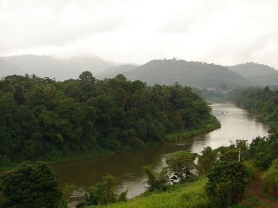 Mahaweli River flowing through Gampola | |
| Location | |
| Country | Sri Lanka |
| Physical characteristics | |
| Source | |
| • location | Horton Plains National Park[1] |
| Mouth | Bay of Bengal |
• location | Trincomalee Bay |
• coordinates | 08°27′34″N 81°13′46″E |
| Length | 335 km (208 mi) |
| Basin size | 10,448 km2 |
| Basin features | |
| Tributaries | |
| • left | Amban Ganga |
| • right | Kotmale Oya |
As part of Mahaweli Development programme the river and its tributaries are dammed at several locations to allow irrigation in the dry zone, with almost 1,000 km2 (386 sq mi) of land irrigated.[5] Production of hydroelectricity from six dams of the Mahaweli system supplies more than 40% of Sri Lanka's electricity needs. One of the many sources of the river is the Kotmale Oya.[6]
There is a misconception in Sri Lanka that the Mahaweli starts in the Sri Pada mountain. The Mahaweli gets its source waters from Horton Plains in Kirigalpoththa and the Thotupola mountain range.
Tributaries
- Nanu Oya
- Puna Oya
- Pundalu Oya
- Kotmale Oya
- Hatton Oya
- Nilamba Oya
- Thalathu Oya
- Hulu Ganga
- Beli Ul Oya
- Kirindi Oya
- Loggal Oya
- Uma Oya
- Badulu Oya
- Amban Ganga
Starting of Mahaweli
The Mahaweli River starts from Polwathura/Mahavila area with its water source starting from the Horton Plains National Park.
See also
- List of rivers in Sri Lanka
- Mahaweli Development programme
References
- "Horton Plains National Park". International Water Management Institute. Archived from the original on August 5, 2010. Retrieved 23 November 2009.
- Room, Adrian (2001-05-01). Placenames of the World. McFarland & Company. ISBN 0-7864-1814-1.
- "Sri Lanka. Water Report 37, 2012". Aquastat. FAO. 2012. Retrieved 30 September 2019.
- Stoddart, David (1996-12-26). Process and Form in Geomorphology. Routledge (UK). ISBN 0-415-10527-7.
- Barry, D. (2001-06-07). Knowledge of the Land. Oxford University Press. ISBN 0-19-829601-0.
- Mahaweli Ganga
External links
Authority control | |
|---|---|
| General |
|
| National libraries | |
На других языках
[de] Mahaweli
Der Mahaweli (singhalesisch: .mw-parser-output .Sinh{font-size:125%}මහවැලි ගඟ mahavæli gaṅga, Tamil: மகாவலி ஆறு mahāvali āṟu oder மகாவலி கங்கை mahāvali gaṅgai) ist mit 335 km Länge der längste Fluss auf Sri Lanka. Er hat von allen Flüssen des Landes auch das größte Einzugsgebiet, welches ein Fünftel der Insel einnimmt.- [en] Mahaweli River
[es] Mahaweli Ganga
Mahaweli Ganga es el mayor río de Sri Lanka. Mahaweli Ganga es un nombre cingalés, que significa "Gran río arenoso".[1][it] Mahaweli
Il fiume Mahaweli (Sinhala: Ganga Mahaweli, letteralmente "Grande fiume sabbioso"; Tamil: மகாவலி ஆறு)[1], è un fiume lungo 335 km (208 miglia), il che lo rende il più lungo dello Sri Lanka. Il suo bacino idrografico è il più grande del paese e copre circa un quinto della superficie totale dell'isola. Il fiume raggiunge il Golfo del Bengala all'estremo nord-orientale di Trincomalee.[ru] Махавели
Махаве́ли[1][2][3][4] (Маха́вели-Га́нга[5][6][7]; синг. මහවැලි ගඟ; там. மகாவலி ஆறு) — крупнейшая река в Шри-Ланке. Длина 335 км.Другой контент может иметь иную лицензию. Перед использованием материалов сайта WikiSort.org внимательно изучите правила лицензирования конкретных элементов наполнения сайта.
WikiSort.org - проект по пересортировке и дополнению контента Википедии