geo.wikisort.org - River
The Bhāgīrathī (Pron: /ˌbʌgɪˈɹɑːθɪ/) is a turbulent Himalayan river in the Indian state of Uttarakhand, and one of the two headstreams of the Ganges, the major river of Northern India and the holy river of Hinduism. In the Hindu faith, mythology, and culture, the Bhagirathi is considered the source stream of the Ganges. However, in hydrology, the other headstream, Alaknanda, is considered the source stream on account of its great length and discharge. The Bhagirathi and Alaknanda join at Devprayag in Garhwal and are thereafter known as the Ganges.
| Bhāgīrathī River | |
|---|---|
 Sacred bathing ghats on Bhagirathi River at Gangotri | |
 Map showing the Himalayan headwaters of the Bhagirathi river. The numbers in parentheses refer to the altitude in meters. | |
| Etymology | "Bhagirathi" (Sanskrit, literally, "caused by Bhagiratha") |
| Native name | भागीरथी (Sanskrit) |
| Location | |
| Country | India |
| State | Uttarakhand, |
| Region | Garhwal division |
| District | Uttar Kashi District, Tehri District |
| Physical characteristics | |
| Source | Gaumukh (gou, cow + mukh, face), about 18 km (11.2 mi) from the town of Gangotri |
| • coordinates | 30.925449°N 79.081480°E |
| • elevation | 3,892 m (12,769 ft) |
| Source confluence | Alaknanda River |
| Mouth | Ganges |
• location | Devprayag, Uttarakhand, India |
• coordinates | 30.146315°N 78.598251°E |
• elevation | 475 m (1,558 ft) |
| Length | 205 km (127 mi) |
| Basin size | 6,921 km2 (2,672 sq mi) |
| Discharge | |
| • average | 257.78 m3/s (9,103 cu ft/s) |
| • maximum | 3,800 m3/s (130,000 cu ft/s) |
| [1] | |
Etymology
Bhagiratha was a descendant of King Sagara of the Suryavanshi, or Surya Dynasty. He played an important role in the descent of the Ganges.[2] The story of Bhagiratha is narrated in the Ramayana, Mahabharata, and Puranas.[3][2]
Wanting to show his sovereignty, King Sagara performed a ritual known as ashvamedha, where a horse was left to wander for one year. However, Indra stole the horse to prevent the ritual from being successful. Learning that the horse had disappeared, King Sagara sent his sixty thousand sons to look for it. They eventually found the horse at the ashram of sage Kapila.[2] Thinking that sage Kapila had stolen the horse, the sons interrupted him while he was in deep meditation. This infuriated sage Kapila and with his ascetic's gaze burned all sixty thousand sons to ashes.[2] King Sagara sent his grandson, Anshuman, to ask sage Kapila what could be done to bring deliverance to their souls.[4]
Sage Kapila advised that only the water of the Ganges, which flowed in the heavens, could liberate them. Bhagiratha, Anshuman's grandson, undertook ascetic practice and won the favour of Brahma and Shiva. Brahma allowed Ganga to descend on earth, while Shiva broke Ganga's fall in the coils of his hair so that her force would not shatter the earth.[4]
When Ganga descended, Bhagiratha took her through the mountains, foothills, the plains of India, and to the sea where she liberated the sixty thousand sons of King Sagara.[2] Due to Bhagiratha's role in the descent of the Ganges, the source stream came to be known as Bhagirathi.[5][6]
Course
The headwaters of the Bhagirathi River are formed at Gaumukh at the foot of the Gangotri glacier. From Gaumukh the river reaches the town of Gangotri. From Gangotri, it travels down a deep gorge and arrives at Bhaironghati. The river continues to travel to Harsil and crosses the Bhagirathi Granite. It then enters a wide valley and meets two tributaries near Jhala. The river continues to flow downwards to Uttarkashi and then through Dharasu, Chinyalisaur, and the old town of Tehri. From Tehri, the river reaches Devprayag via the Himalayas. At Devprayag, the Bhagirathi River converges with the Alaknanda River and travels onward as the Ganges River.[7]
The Bhagirathi River is mythologically known to be the source stream for the Ganges River. In hydrology, the Alaknanda is the source stream for the Ganges River due to its length and discharge. The Alaknanda River, including its tributaries, is 664.5 km (412.9 mi) and the Bhagirathi River, including its tributaries, is 456.5 km (283.7 mi).[7]
Tributaries
The Bhagirathi River is joined by several tributaries; these are, in order from the source:
- Kedar Ganga at Gangotri (elevation 3,049 m (10,003 ft)),
- Jadh Ganga at Bhaironghati (elevation 2,650 m (8,690 ft)),
- Kakora Gad and Jalandhari Gad near Harsil (elevation 2,745 m (9,006 ft)),
- Siyan Gad near Jhala (elevation 2,575 m (8,448 ft)),
- Asi Ganga near Uttarkashi (elevation 1,158 m (3,799 ft)),
- Bhilangna River near Old Tehri (elevation 755 m (2,477 ft)).
The Bhilangna itself rises at the foot of the Khatling Glacier (elevation 3,717 m (12,195 ft)) approximately 50 km (31 mi) south of Gaumukh.
The controversial Tehri dam lies at the confluence of the Bhagirathi River and the Bhilangna, at 30°22′32″N 78°28′48″E, near Tehri. Chaukhamba I is the highest point of the Bhagirathi basin.
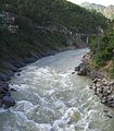 The turbulent Bhagirathi as it enters Devprayag.
 The Bhagirathi (foreground) on its way to meet the sediment-laden Alaknanda, and to flow on as the Ganges.
 Another view of the confluence at Devprayag.
 Tehri Dam, the 5th tallest dam in the world


Dams
There are 18 dams along the Bhagirathi River , either in operation, under construction or planned. These are, in order from the source:
| # | Name | Ht | MW | Status | FRL | MWL | HRT | TRT | TWL | RBL | Coordinates |
|---|---|---|---|---|---|---|---|---|---|---|---|
| 1 | Karmoli Dam | 140 | planned | 8.6 | |||||||
| 2 | Gangotri Dam | 55 | planned | 5.2 | |||||||
| 3 | Jadhganga Dam | 50 | planned | 1.1 | |||||||
| 4 | Bhaironghati I Dam | 380 | planned | ||||||||
| 5 | Bhaironghati II Dam | 65 | planned | ||||||||
| 6 | Harsil Dam | 210 | planned | 5.06 | |||||||
| 7 | Loharinag Pala Hydro Power Project | 600 | cancelled | 2,147 | 1,667 | 13.85 | .51 | 1.665 | 30°58′6″N 78°41′56″E | ||
| 8 | Pala Maneri I Dam | 78 | 480 | cancelled | 1,665 | 1,667 | 12.563 | 1.378 | |||
| 9 | Maneri Dam | 38 | 90 | operation | 8.631 | ||||||
| 10 | Joshiyara (Bhali) Dam | 304 | operation | 16.0 | |||||||
| 11 | Bhilangana II Dam | 11 | planned | ||||||||
| 12 | Bhilangana I Dam | 22.5 | planned | 2.0 | |||||||
| 13 | Tehri Dam | 260.5 | 2,400 | operation | 830 | 835 | 1.634 | .8625 | 30°22′40″N 78°28′50″E | ||
| 14 | Koteshwar Dam | 97.5 | 400 | operation | 612.50 | 615 | |||||
| 15 | Kotli Bel 1A Dam | 82.5 | 195 | construction | |||||||
| 16 | Kotli Bel 1B Dam | 90 | 320 | cancelled | |||||||
| 17 | Kotli Bel II Dam | 82 | 530 | cancelled | |||||||
Notes
- Catchment Area Treatment:, Bhagirathi River Valley Development Authority, Uttaranchal
- Eck, Diana L. (2012). India : a sacred geography. New York: Harmony Books. pp. 216–221.
{{cite book}}: CS1 maint: date and year (link) - Mankodi, Kirit (1973) "Gaṅgā Tripathagā"Artibus Asiae 35(1/2): pp. 139-144, p. 140
- Sen, Sudipta (2019). Ganges : the many pasts of an Indian River. New Haven: Yale University Press. p. 56.
{{cite book}}: CS1 maint: date and year (link) - Rice, Earle Jr. (2013). The Ganges river. Hockessin, Del.: Mitchell Lane Publishers. p. 9.
- Gopal, Madan (1990). K.S. Gautam (ed.). India through the ages. Publication Division, Ministry of Information and Broadcasting, Government of India. p. 76.
- Singh, Sandeep (2018), Singh, Dhruv Sen (ed.), "Alakhnanda–Bhagirathi River System", The Indian Rivers: Scientific and Socio-economic Aspects, Springer Hydrogeology, Singapore: Springer, p. 108, doi:10.1007/978-981-10-2984-4_8, ISBN 978-981-10-2983-7, retrieved 8 April 2022
- "Map of the Bhagirathi River showing dams" (PDF). Dams, Rivers & People. South Asian Network on Dams Rivers & People(sandrp.in). August 2008. Archived from the original (PDF) on 23 May 2011. Retrieved 7 March 2010.
References
- Wilson, W. (1860). A summer ramble in the Himalayas: with sporting adventures in the Vale of Cashmere. London: Hurst and Blackett. OCLC 58410561. available on microfilm
- Heske, Franz (1937). Im heiligen Lande der Gangesquellen (In the Holy Lands of the Source of the Ganges) (in German). Neudamm, Germany: J. Neumann. OCLC 35036471.
- Sharma, Man Mohan (1997). Through the Valley of Gods: Travels in the Central Himalayas (2 ed.). New Delhi: Vision Books. OCLC 4547622.
External links
| Authority control |
|
|---|
На других языках
[de] Bhagirathi
Die Bhagirathi (Hindi: भागीरथी Bhāgīrathī) ist der rechte Quellfluss des Ganges in Indien.- [en] Bhagirathi River
[it] Bhagirathi
Il Bhagirathi è un fiume turbolento nello Stato del Uttarakhand, India, che ha origine dal Ghiacciaio di Gangotri, nella catena montuosa dell'Himalaya.[ru] Бхагиратхи
Бхагира́тхи (хинди भागीरथी, IAST: Bhāgīrathī) — горная гималайская река в индийском штате Уттаракханд, главный исток реки Ганг, важнейшей реки Индии и священной реки индуизма.Другой контент может иметь иную лицензию. Перед использованием материалов сайта WikiSort.org внимательно изучите правила лицензирования конкретных элементов наполнения сайта.
WikiSort.org - проект по пересортировке и дополнению контента Википедии