geo.wikisort.org - River
The Alaknanda is a Himalayan river in the Indian state of Uttarakhand and one of the two headstreams of the Ganges, the major river of Northern India and the holy river of Hinduism. In hydrology, the Alaknanda is considered the source stream of the Ganges on account of its greater length and discharge;[1] however, in Hindu tradition and culture, the other headstream, the Bhagirathi, is considered the source stream.
This article may require cleanup to meet Wikipedia's quality standards. The specific problem is: Religious significance section needs to be clearer. (June 2022) |
| Alakanandā | |
|---|---|
 The sediment-laden Alaknanda river flowing into Devprayag, Uttarakhand. | |
 The Himalayan headwaters of the Ganges river in the Garhwal region of Uttarakhand, India. The Alaknanda is the left bank tributary of the Ganges at Devprayag. | |
| Location | |
| Country | India |
| State | Uttarakhand |
| Region | Garhwal division |
| District | Chamoli, Rudraprayag, Pauri Garhwal |
| Physical characteristics | |
| Source | Confluence of Satopanth Glacier and Bhagirathi Kharak Glacier |
| • elevation | 3,880 m (12,730 ft) |
| 2nd source | Bhagirathi River |
| Mouth | Ganges |
• location | Devprayag, Uttarakhand, India |
• elevation | 475 m (1,558 ft) |
| Length | 195 km (121 mi) |
| Basin size | 10,882 km2 (4,202 sq mi) |
| Discharge | |
| • average | 439.36 m3/s (15,516 cu ft/s) |
| Basin features | |
| Tributaries | |
| • left | Saraswati, Dhauliganga, Nandakini, Pindar |
| • right | Mandakini |
Course
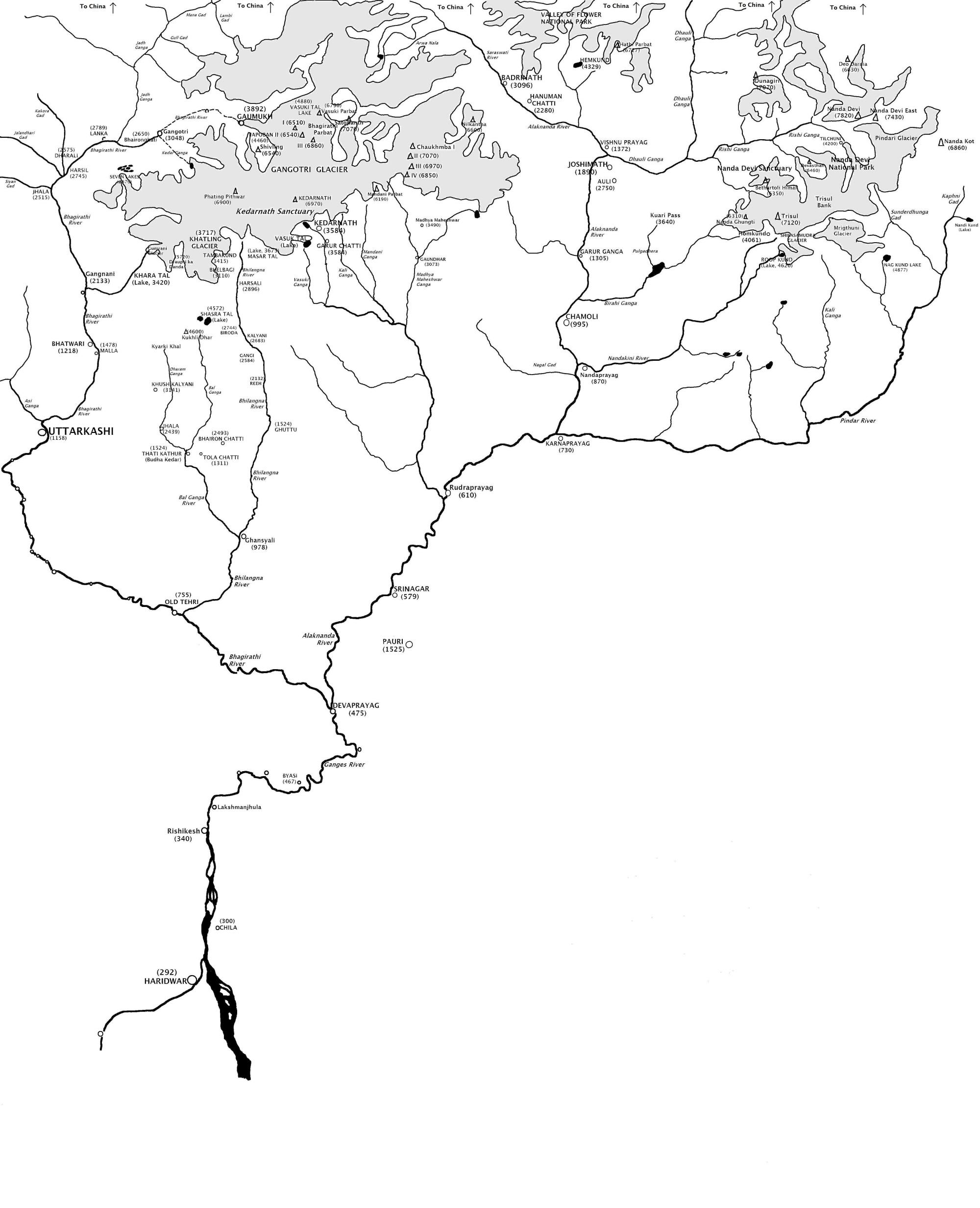
The Alaknanda rises at the confluence and foot of the Satopanth and Bhagirath Kharak glaciers in Uttarakhand.[2][3] From its origin, it travels to the village of Mana, meets with the Saraswati River, a right bank tributary, and continues downstream through narrow valleys. It reaches the Badrinath valley, arrives at Hanumanchatti, and meets with the Ghrit Ganga, a right bank tributary. From Hanumanchatti, the river goes to Pandukeshwar and flows through wide valleys and steep terrains. At Vishnuprayag it meets Dhauliganga, a left bank tributary, and travels west to the town of Joshimath. From Joshimath, the Alaknanda crosses the Main Central Thrust near Helang. It then meets with Birahi Ganga, a left bank tributary at Birahi. The river reaches the town of Nandprayag and joins with the Nandakini River, a left bank tributary. At Karanprayag, the Pindar River, a left bank tributary, meets with the Alaknanda River. At Rudraprayag, it meets with the Mandakini River, a right bank tributary. As the Alaknanda flows past Rudraprayag, it enters a wide valley near Srinagar, Garhwal. At Devprayag the Alaknanda River converges with the Bhagirathi River and travels onward as the Ganges River.[4]
The Alaknanda contributes a significantly larger portion to the flow of the Ganges than the Bhagirathi.[4] The Alaknanda system drains parts of Chamoli, Tehri, and Pauri districts.[5]
Religious significance
The Alaknanda River is of special interest to the pilgrims who visit the important pilgrimage places in Uttarakhand. The Ganges as Alaknanda rises in the southern Himalayas on the Indian side of the Tibet border. On the Satopanth Glacier 6 km (3.73 mi) up from Alaknanda's origin at its snout, the triangular Lake Satopanth is found at a height of 4,350 m (2.70 mi). It is named after the Hindu trinity, Brahma, Vishnu, and Shiva.
Badrinath Rishi Ganga River meet Alaknanda
Badrinath, one of the holy destinations for Hindus in India is located near to the bank of the Alaknanda River. This place is surrounded by two mountain ranges of Nar and Narayan on either sides and Neelkanth peak located at the back of Narayan range.
- Govindgath :. LaxmanGanga meet Alaknanda
Panch Prayag
Several rivers in the Garhwal region merge with the Alaknanda at places called prayag or 'holy confluence of rivers'. These are:[6]
- Vishnuprayag, where the Alaknanda is met by the Dhauliganga River
- Nandaprayag, where it is met by the Nandakini River
- Karnaprayag, where it is met by the Pindar River
- Rudraprayag, where it is met by the Mandakini River
- Devprayag, where it meets the Bhagirathi River and officially becomes the Ganges

Recreation
The Alaknanda river is among the best for river rafting in the world due to its high rafting grade.[7]
Dams
There are 37 hydroelectric dams in operation, under construction or planned to harness the energy of the Alaknanda river and its tributaries and generate electricity.[8]
| # | Name | Electrical output capacity (MW) | Status | Dam height (m) | Full reservoir level (MSL) (m) | River bed level at dam site (MSL) (m) | Head race tunnel length (km) | Tail race tunnel length (m) | Tail water level (MSL) (m) |
|---|---|---|---|---|---|---|---|---|---|
| 1 | Badrinath | 1.25 | operational | ||||||
| 2 | Tapovan | 0.8 | operational | ||||||
| 3 | Tharali | 0.4 | operational | ||||||
| 4 | Tilwara | 0.2 | operational | ||||||
| 5 | Urgam | 3 | operational | ||||||
| 6 | Vishnuprayag | 400 | operational | 14 | 11.323 | ||||
| 7 | Kaliganga-I | 4 | under construction | ||||||
| 8 | Kaliganga-II | 6 | under construction | ||||||
| 9 | Koti Bhel IB | 320 | under construction | 90 | 521 | 452.5 | 230 | 463.2 | |
| 10 | Koti Bhel II | 530 | under construction | 82 | 458.5 | 401.4 | 390 | 411.1 | |
| 11 | Madhamaheshwar | 10 | under construction | ||||||
| 12 | Tapovan Vishnugad | 520 | under construction | 22 | 803.5 | 513 | 1267 | ||
| 13 | Shrinagar | 330 | under construction | ||||||
| 14 | Singoli Bhatwari | 99 | under construction |
There are 23 other proposed projects in the Alaknanda river basin through which the power-potential of the Alaknanda and its tributaries can be harnessed. The proposed 23 hydel-projects are as follows -
- Alaknanda (Badrinath) (300 MW)
- Bagoli (72 MW)
- Bowla Nandprayag (132 MW)
- Chuni Semi (60 MW)
- Deodi (60 MW)
- Devsari Dam (255 MW)
- Gaurikund (18.6 MW)
- Gohana Tal (60 MW)
- Jelam Tamak (60 MW)
- Karnaprayag (160 MW)
- Lakshmanganga (4.4 MW)
- Lata Tapovan (310 MW)
- Maleri Jelam (55 MW)
- Nandprayag Langasu (141 MW)
- Padli Dam (27 MW)
- Phata-Byung (10.8 MW)
- Rambara (24 MW)
- Rishiganga I (70 MW)
- Rishiganga II (35 MW)
- Tamak Lata (280 MW)
- Urgam II (3.8 MW)
- Utyasu Dam (860 MW)
- Vishnugad Pipalkoti (444 MW)
Towns along the Alaknanda River
As the river flows, the towns along its banks are Badrinath, Vishnuprayag, Joshimath, Chamoli, Nandaprayag, Karnaprayag, Rudraprayag, Srinagar and Devprayag. At each town with suffix prayag, Alaknanda meets another river.
Photo gallery
 Rudraprayag - confluence of Alaknanda and Mandakini
 Alaknanda river near the town of Srinagar in Uttarakhand
 Alaknanda joins Bhagirathi at Devprayag to form the Ganges


See also
- 2013 North India floods
- 2021 Uttarakhand flood
References
- Gopal, Madan (1990). K.S. Gautam (ed.). India through the ages. Publication Division, Ministry of Information and Broadcasting, Government of India. p. 65.
- "eUttaranchal".
- In Hindu culture "The Story of Ganga : The River Goddess".
- Singh, Sandeep (2018), Singh, Dhruv Sen (ed.), "Alakhnanda–Bhagirathi River System", The Indian Rivers: Scientific and Socio-economic Aspects, Singapore: Springer, pp. 107–108, doi:10.1007/978-981-10-2984-4_8, retrieved 13 April 2022
- Singh Negi, Sharad (1995). Uttarakhand: Land and People, page 6. MD Publications Pvt Ltd. ISBN 81-85880-73-5.
- Kapadia, Harish (2001). Trekking and Climbing in the Indian Himalaya, page 89. Stackpole Books. ISBN 0-8117-2953-2.
- "11 Top Destinations for River Rafting in India - Travel News India". travelnewsindia.com. 31 January 2017. Archived from the original on 11 March 2018. Retrieved 31 January 2017.
- Hydroelectric Projects on Alaknanda River Basin, by South Asia Network on Dams Rivers and People, www.sandrp.in
External links
- Alaknanda River Britannica.com
- Prayags at GMVN
Authority control | |
|---|---|
| General |
|
| National libraries | |
На других языках
[de] Alaknanda
Die Alaknanda (oder Alakananda; Sanskrit: अळकनन्दा) bildet den linken Quellfluss des Ganges.- [en] Alaknanda River
[es] Río Alaknanda
El río Alaknanda, o Alakananda (en sánscrito, अळकनन्दा; en hindi, अलकनन्दा नदी) es un río del Himalaya indio, una de las dos fuentes del río Ganges. Proviene del glaciar Satopanth en el estado de Uttaranchal, y se une con el río Bhagirathi, la fuente principal del Ganges, cerca de la pequeña localidad de Devprayag, después de recorrer alrededor de 200 kilómetros. Después de la confluencia se se considera que nace nominalmente el Ganges, al que el Alaknanda aporta un flujo considerable.[it] Alaknanda
L’Alaknanda o Alakananda (in sanscrito: अळकनन्दा; in hindi: अलकनन्दा नदी) è un fiume dell'India settentrionale che scorre nello stato dell'Uttarakhand.[ru] Алакнанда
Алакнанда[2] (устар.: Алакнанда-Ганга[3], Алакананда[4]; хинди अलकनन्दा नदी, англ. Alaknanda) — река в Гималаях. Находится в индийском штате Уттаракханд, меньшая из двух рек (с Бхагиратхи), которые при слиянии формируют реку Ганг. Длина реки оценивается 229[1] или 240 км[5]. Площадь речного бассейна составляет 10237 км²[5]. Исток находится в горах на высоте 3800 м над уровнем моря. Верховье реки протекает через узкие и глубокие ущелья. Левыми притоками являются реки Сарасвати, Дхаулиганга, Гарунганга, Паталганга, Бирехиганга, Нандакини и Пиндар, а правым — Мандакини[1].Другой контент может иметь иную лицензию. Перед использованием материалов сайта WikiSort.org внимательно изучите правила лицензирования конкретных элементов наполнения сайта.
WikiSort.org - проект по пересортировке и дополнению контента Википедии