geo.wikisort.org - River
Jalangi River (Bengali: জলঙ্গী নদী), is a branch of the Ganges river in Murshidabad and Nadia districts in the Indian state of West Bengal. It flows into the Bhagirathi river and strengthens its lower channel, the Hooghly.[1]
| Jalangi River খড়িয়া | |
|---|---|
 | |
 | |
| Native name | |
| Location | |
| Country | India |
| State | West Bengal |
| One of the three Nadia Rivers | |
| District | Murshidabad and Nadia |
| Cities | Krishnanagar, Tehatta, Mayapur |
| Physical characteristics | |
| Source | River Padma |
| • location | The Jalangi leaves the Ganges or Padma at Char Madhubona in Karimpur-I, Nadia district |
| • coordinates | 20°05′26″N 88°41′53″E |
| Mouth | Bhagirathi |
• location | Swarupganj, opposite Nabadwip, the birth-place of Sri Chaitanya |
• coordinates | 23°29′23″N 88°28′57″E |
| Length | 233 km (145 mi) |
| Basin size | 2,815.33 km2 (1,087.00 sq mi) |
| Width | |
| • minimum | 75.89 m (0.04716 mi) at Moktarpur–Chandpur |
| • average | 162.58 m (0.10102 mi) |
| • maximum | 224.21 m (0.13932 mi) at Moktarpur–Velanagar |
| Depth | |
| • minimum | 0.82 m (0.00051 mi) at Jitpur-Saguna cross section |
| • maximum | 7.74 m (0.00481 mi) at Sibpur-Hatishala cross section |
| Discharge | |
| • location | Bhagirathi-Hooghly |
| Basin features | |
| Tributaries | |
| • left | Bhairab Khal (different from Bhairab river and a different channel), Kesto-Raier Khal, Saraswati Khal, River Anjana |
| • right | Sialmari, Bhairab River, Chhoto Bhairab, Gobra-Suti Nala, Kalma Khal |
The river below the point where the Jalangi meets the Ganges is known as Hooghly and the course above it from the point of its separation from the main flow of the Ganges to its confluence with the Jalangi, it is called Bhagirathi.[2]
Ghurni, a neighbourhood of Krishnanagar, a centre for the production of clay dolls, often referred to as Krishnanagar clay dolls, is located on the banks of the Jalangi. Nabadwip, the birthplace of Chaitanya Mahaprabhu is located in the west bank of the united flow of river Jalangi and Bhagirathi.[3] Mayapur is located at the confluence of the Jalanagi and Bhagirathi.
Etymology
The name Jalangi derives from two Bengali words Jal (Water) and Angi (who (female) possess body). ‘Jalangi’ is a Bengali word meaning ‘watery body’ or ‘the body is made of water’.[4] However, the name ‘Jalangi’ has been derived from that very settlement ‘Jalangi’ in P.S. Jalangi of Murshidabad district, at which, the river would take-off its supply from river Padma (Majumder, 1995, p-37)
The course of the river
Jalangi is a moribund river of 233 km in length in the Bhagirathi-Hooghly basin. The river is simultaneously a distributary of the river Padma and a tributary of the river Bhagirathi. The reach of 9.1 km from abandoned off-take at Char Madhubona near Gopalpur (Ghat) to Sialmari confluence at Kopila is erased out from the map of the region and 41.9 km from Sialmari confluence to Bhairab-Jalangi confluence at Moktarpur, though traceable but dead at present. The reach downstream to the Bhairab-Jalangi confluence up to Jalangi-Bhagirathi confluence at Swarupganj (182km) is being maintained by the base flow of seepage water, contribution of Bhairab, and other spills during two months of the rainy season.[5]
The Jalangi leaves the Ganges or Padma at the extreme north of the Nadia district at 24°05´26´´ N and 88°41´53´´ E and joins the river Bhagirathi at Swarupganj (23°24´42´´ N and 88°22´50´´ E), opposite Nabadwip, the birth-place of Sri Chaitanya.
1. Offtake at Char-Madhubona to Sialmari Confluence at Kopila 9.10 km (Untraceable) 2. Sialmari Confluence at Kopila to Bhairab Confluence at Moktarpur 41.9 km (Dead) 3. Bhairab Confluence at Moktarpur to Suti Confluence at Bali-Tungi 42.7 km 4. Suti Confluence at Bali-Tungi to Kalma Khal Confluence at Radhanagar 55.2 km 5. Kalma Khal Confluence at Radhanagar to Bhagirathi-Jalangi Confluence at Swarupganj 84.1 km Total length from Offtake at Char-Madhubona to Bhagirathi-Jalangi Confluence at Swarupganj 233 km [6]
Changes in the course of rivers
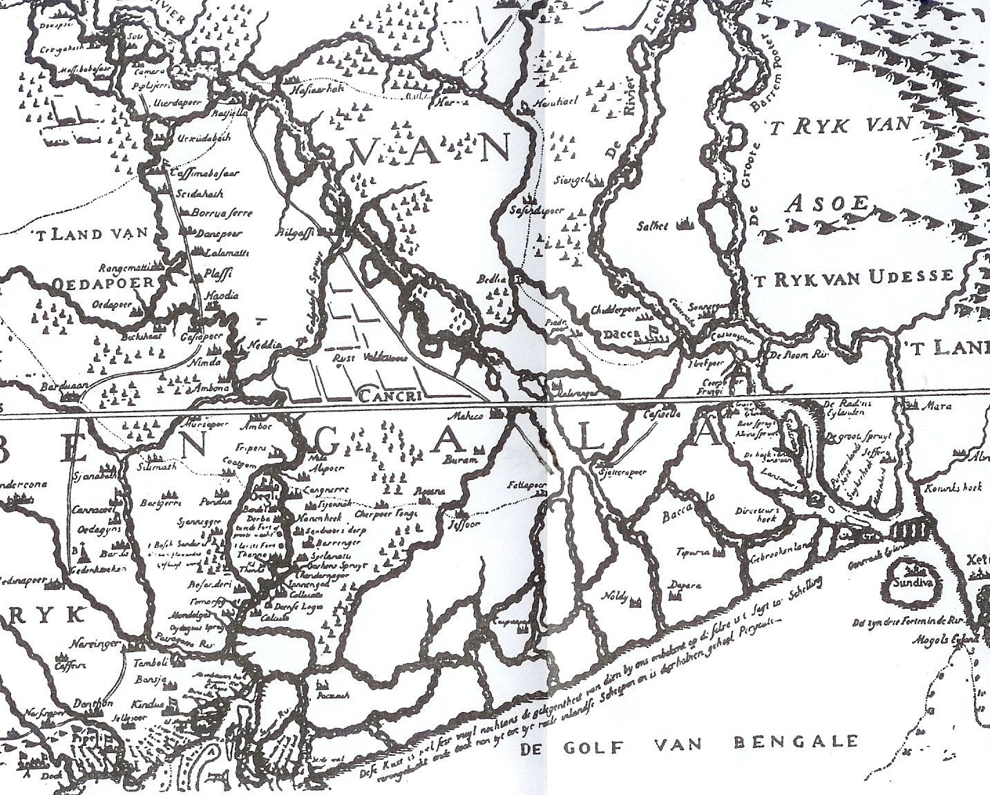
The Jalangi is a modern stream, but its age is not known. Apparently it opened up long after the Bhairab River ran as a strong stream in a south easterly direction. Although it is generally believed that the river has opened up within the last few hundred years, there is no direct evidence of this.[7] It is shown in Van den Brouck's map.[8]
The Bhairab once flowed from the Ganges, across the present beds of the Jalangi, and further eastwards towards Faridpur. The Bhairab is no more a very active river. The Mathabhanga is a younger stream than Jalangi and it was not till very recently that the river completed its junction with the Hooghly by adopting the Churni (now its lower reaches) for its main course. Earlier most of the water of the Mathabhanga ran off to the east down the Kumara, Chitra, Coboduk (Bhairab), and Ichamati, but all these escape routes have been shut off, except a small amount for the Ichamati.[7]
The point to note is that while earlier the rivers in the region flowed in a south-easterly direction, but later some force pulled the Jalangi and the Mathabhanga in a south-westerly direction. The inference is that it occurred because of a local subsidence, which was active for some period prior to 1750 and which has since become inactive.[7]
Erosion
Erosion of the banks is not only a problem for the more turbulent rivers such as Padma and Bhagirathi, but also comparatively smaller rivers such as Jalangi. In 2006, the state government sanctioned Rs. 7 crore for anti-erosion work in the Jalangi River.[9][10]
Bridge
At present, there are 3 complete road-bridges and 2 rail-bridges on the river Jalangi. Three incomplete road bridges are also waiting for completion. From upstream to downstream, those are-
- Karimpur-Bakshipur road bridge (incomplete) On Karimpur-Domkal Road,
- Fazilnagar-Amtala road bridge (incomplete) On proposed Fazilnagar-Amtala Road
- Radhanagar-Patikabari road bridge On Radhanagar-Patikabari-Nawda-Amtala Road
- Dwijendralal Setu (দ্বিজেন্দ্রলাল সেতু), inaugurated by Honorable Pūrta & Ābāsana Minister Sri Jatin Chakraborty on 1st July 1979 On Palashipara-Tehatta Road,at Palashipara
- Dwijendra Setu (দ্বিজেন্দ্র সেতু), named by Honorable Pūrta & Sarak minister Sri Kshiti Goswami on 21st July 1995 On NH 12 formerly NH-34 at Krishnagar
- Proposed Road Bridge-II On NH-12 at Krishnagar
- Old Rail Bridge at Krishnagar On Sealdah-Lalgola Railway inaugurated in 1905
- New Rail Bridge at Krishnagar On Sealdah-Lalgola Railway at Krishnagar inaugurated in 2012[11]
Bengali poetry
- The Jalangi is emotionally referred to by the modern Bengali poet Jibanananda Das in his poem abar asibo phire:[12][13]
- "abar asibo ami banglar nodi math khet bhalobeshe
- jalangir dheuey bheja banglar e shobuj korun dangaey"
- (When again I come, smitten by Bengal's rivers and fields, to this
- Green and kindly land, Bengal, moistened by the Jalangi river's waves.)
- Lyricist Sagar Chattapadhyaya and folk singer Bablu Halder's song is well known regarding the Jalangi river.
- Oo Amar Jalangi Nadi,
- Tor Kolete Roilam Ami, Janamo Abodhi
Photo Gallery
 Jalangi near Krishnanagar, West Bengal, India
 Beauty of Jalangi River (Pricky Poppy flowers)
 River Jalangi at Krishnanagar
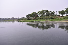 tJalangi River near Mayapur, Nadia 11


References
- Majumdar, Dr. R.C., History of Ancient Bengal, First published 1971, Reprint 2005, p. 4, Tulshi Prakashani, Kolkata, ISBN 81-89118-01-3.
- Bandopadhyay, Dilip Kumar, Bharater Nadi (Rivers of India), 2002, (in Bengali), p. 68, Bharati Book Stall, 6B Ramanath Mazumdar Street, Kolkata
- Das, Balai Chandra; Ghosh, Sandipan; Islam, Aznarul; Roy, Suvendu (2020-10-27). Anthropogeomorphology of Bhagirathi-Hooghly River System in India. CRC Press. p. 387. ISBN 978-1-000-19457-9.
- Das, Balai Chandra; Ghosh, Sandipan; Islam, Aznarul; Roy, Suvendu (2020-10-27). Anthropogeomorphology of Bhagirathi-Hooghly River System in India. CRC Press. p. 385. ISBN 978-1-000-19457-9.
- 2. Das BC and Bhattacharya S (2020). The Jalangi: A Story of Killing of a Dying River. In Das et al. (2020) eds. Anthropogeomorphology of Bhagirathi-Hooghly River System in India. Taylor & Francis Group. ISBN (eBook) 9781003032373. https://doi.org/10.1201/9781003032373
- 2. Das BC and Bhattacharya S (2020). The Jalangi: A Story of Killing of a Dying River. In Das et al. (2020) eds. Anthropogeomorphology of Bhagirathi-Hooghly River System in India. Taylor & Francis Group. ISBN (eBook) 9781003032373. https://doi.org/10.1201/9781003032373
- Hirst, Major F.C., Director of Surveys, Bengal and Assam, Report on the Nadia Rivers 1915, first published in 1916 by the Bengal Secretariat Book Depot, reproduced in Rivers of Bengal, Vol III, p.27, West Bengal District Gazetteers, Higher Education Department, Government of West Bengal, 2002.
- Roy, Niharranjan, Bangalir Itihas, Adi Parba, (in Bengali), first published 1972, reprint 2005, p. 84, Dey's Publishing, 13 Bankim Chatterjee Street, Kolkata, ISBN 81-7079-270-3
- Pramanick, Asim. "Rivers wreak havoc". Bengal. The Statesman, 27 August 2005. Retrieved 2007-11-28. [dead link]
- "Rs. 63 crore to stem erosion in Nadia". Bengal. The Statesman, 11 August 2006. Retrieved 2007-11-28. [dead link]
- Das, Balai Chandra; Ghosh, Sandipan; Islam, Aznarul; Roy, Suvendu (2020-10-27). Anthropogeomorphology of Bhagirathi-Hooghly River System in India. CRC Press. pp. 265–279. ISBN 978-1-000-19457-9.
- Bandopadhyay, Dilip Kumar, p. 226
- "Zibananada Das". Abar Asibo Firey. Fortune City. Archived from the original on 2007-10-13. Retrieved 2007-11-28.
На других языках
[de] Jalangi
Der Jalangi (bengalisch .mw-parser-output .Beng{font-size:110%}জলঙ্গী নদী, Hindi .mw-parser-output .Deva{font-size:120%}@media all and (min-width:800px){.mw-parser-output .Deva{font-size:calc(120% - ((100vw - 800px)/80))}}@media all and (min-width:1000px){.mw-parser-output .Deva{font-size:100%}}जलङ्गी/जलंगी नदी Jalaṅgī nadī) ist ein ca. 250 km langer und ca. 100 bis 200 m breiter Fluss im Bereich des Gangesdeltas im Distrikt Nadia im indischen Bundesstaat Westbengalen. Aufgrund der geringen Gefällesituation im Gangesdelta bildet er eine Verbindung zwischen den beiden Gangeshauptarmen Padma und Hugli. Nördlich der Einmündung des Jalangi in den westlichen Gangesarm wird dieser Bhagirathi genannt, südlich davon Hugli.- [en] Jalangi River
[ru] Джаланги
Джала́нги (англ. Jalangi, бенг. জলজ্ঞী নদী) — река в Индии, один из рукавов Ганга, впадающий в реку Хугли. Джаланги протекает по территории округов Муршидабад и Надия в штате Западная Бенгалия[1][2]. На берегах Джаланги расположено бенгальское селение Гхурни в районе Кришнанагара, которое является крупным центром глиняной скульптуры. В месте слияния Ганги и Джаланги расположен Маяпур — место рождения индуистского святого Чайтаньи Махапрабху и священное место паломничества для кришнаитов.Другой контент может иметь иную лицензию. Перед использованием материалов сайта WikiSort.org внимательно изучите правила лицензирования конкретных элементов наполнения сайта.
WikiSort.org - проект по пересортировке и дополнению контента Википедии