geo.wikisort.org - River
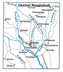
The Dhaleshwari River (Bengali: ধলেশ্বরী Dhôleshshori) is a distributary, 160 kilometres (99 mi) long, of the Jamuna River in central Bangladesh. It starts off the Jamuna near the northwestern tip of Tangail District. After that it divides into two branches: the north branch retains the name Dhaleshwari and merges with the other branch, the Kaliganga River at the southern part of Manikganj District. Finally the merged flow meets the Shitalakshya River near Narayanganj District. This combined flow goes southwards to merge into the Meghna River.
This article does not cite any sources. (May 2022) |
| Dhaleshwari River | |
|---|---|
 | |
 | |
| Location | |
| Country | Bangladesh |
| Physical characteristics | |
| Source | Jamuna River |
| Length | 160 km (99 mi) |
| Discharge | |
| • location | Shitalakshya River |

Average depth of river is 122 feet (37 m) and maximum depth is 265 feet (81 m).
See also
- Rivers of Bangladesh
References
На других языках
[de] Dhaleshwari
Dhaleshwari ist ein 160 km langer, bis zu 81 m tiefer Mündungsarm der Jamuna in Bangladesch.- [en] Dhaleshwari River
[it] Dhaleswari
Il Dhaleswari è un fiume del Bangladesh centrale. Costituisce un braccio del fiume Jamuna (il corso principale del Brahmaputra), che lascia a sud/sud-ovest di Tangail. Prosegue serpeggiando in direzione sud-est per circa 160 km attraverso una regione intensamente coltivata a iuta e riso a ovest e a sud di Dacca fino a congiungersi al fiume Meghna nei pressi di Narayanganj.Текст в блоке "Читать" взят с сайта "Википедия" и доступен по лицензии Creative Commons Attribution-ShareAlike; в отдельных случаях могут действовать дополнительные условия.
Другой контент может иметь иную лицензию. Перед использованием материалов сайта WikiSort.org внимательно изучите правила лицензирования конкретных элементов наполнения сайта.
Другой контент может иметь иную лицензию. Перед использованием материалов сайта WikiSort.org внимательно изучите правила лицензирования конкретных элементов наполнения сайта.
2019-2025
WikiSort.org - проект по пересортировке и дополнению контента Википедии
WikiSort.org - проект по пересортировке и дополнению контента Википедии