geo.wikisort.org - River
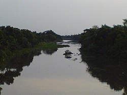
Bhairab River (Bengali: ভৈরব নদী) is a river in south-western Bangladesh, a distributary of the Ganges.[1] It passes through Khulna, dividing the city into two parts. Bhairab River originates from Tengamari border of Meherpur District and passes through Jessore city.[2] The river is approximately 160 kilometres (100 mi) long and 91 metres (300 ft) wide. Its average depth is 1.2 to 1.5 metres (4 to 5 ft) and with minimal water flow, it has plenty of silt.[3]

Early history
The Bhairab, which is considered to be of older origin than its parent river the Jalangi, takes off from that river at a point, a few miles north of Karimpur near Akheriganj at Bhagwangola (Vidhan Sabha constituency) in Murshidabad district (in West Bengal). After a tortuous course towards the south it turns to the east forming the boundary line between Meherpur P.S. (Bangladesh) and Karimpur (India) for a short distance and then turning south enters Meherpur P.S. and flows past Meherpur town to the south and loses itself in the Mathabhanga close to the east of Kapashdanga. Its intake from the Jalangi having silted up, this river has been practically dead since long. The poor climate of Meherpur, which lies upon its banks is in great measure attributed to the stagnancy of its water.
Geography
Bhairab River has two main branches, the Khulna-Ichamati and the Kobadak. The Khulna-Ichamati forms a boundary between Bangladesh and India. The towns of Khulna and Jessore are situated on the bank of the river.[2] The development of their settlements and culture were influenced by the river. The Rupsa River is formed from the Bhairab and the Atai River, and flows into the Pasur River.[4]
References
- Rob, Md Abdur (2012). "Ganges-Padma River System". In Islam, Sirajul; Jamal, Ahmed A. (eds.). Banglapedia: National Encyclopedia of Bangladesh (Second ed.). Asiatic Society of Bangladesh.
- "Geology of the Khulna City". Department of Geology and Mining, University of Rajshahi. Retrieved 19 July 2010.
- Hossain, Dr. Md Arshad (November 1994). "Assistance to Fisheries Research Institute — Report Prepared by a National Consultant on Pen Culture". Food and Agricultural Organization of the United Nations. Retrieved 7 July 2010.
- Chowdhury, Masud Hasan (2012). "Rupsa-Pasur River". In Islam, Sirajul; Jamal, Ahmed A. (eds.). Banglapedia: National Encyclopedia of Bangladesh (Second ed.). Asiatic Society of Bangladesh.
External links
- Chowdhury, Masud Hasan (2012). "Bhairab River". In Islam, Sirajul; Jamal, Ahmed A. (eds.). Banglapedia: National Encyclopedia of Bangladesh (Second ed.). Asiatic Society of Bangladesh.
На других языках
[de] Bhairab (Fluss)
Der Bhairab (bengalisch .mw-parser-output .Beng{font-size:110%}ভৈরব) ist ein ca. 160 km langer und etwa 100 bis 200 m breiter Fluss im Gangesdelta in Indien und Bangladesch; an seinen Ufern liegen die Städte Jessore und Khulna sowie die Historische Moscheenstadt Bagerhat.- [en] Bhairab River
Другой контент может иметь иную лицензию. Перед использованием материалов сайта WikiSort.org внимательно изучите правила лицензирования конкретных элементов наполнения сайта.
WikiSort.org - проект по пересортировке и дополнению контента Википедии
