geo.wikisort.org - River
Teesta River is a 414 km (257 mi) long river that rises in the Pauhunri Mountain of eastern Himalayas, flows through the Indian states of Sikkim and West Bengal through Bangladesh and enters the Bay of Bengal.[1] It drains an area of 12,540 km2 (4,840 sq mi).[2] In India, it flows through Mangan District, Gangtok District, Pakyong District, Kalimpong district, Darjeeling District, Jalpaiguri District, Cooch Behar districts and the cities of Rangpo, Jalpaiguri and Mekhliganj. It joins the Brahmaputra River at Phulchhari Upazila in Bangladesh. 305 km (190 mi) of the river lies in India and rest in Bangladesh. Teesta is the largest river of Sikkim and second largest river of West Bengal after the Ganges.
| Teesta River | |
|---|---|
 Teesta in Siliguri, West Bengal | |
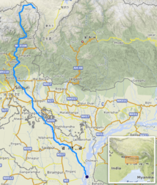 Path of the Teesta | |
 Source of Teesta river in Sikkim  Teesta River (India) | |
| Location | |
| Country | India, Bangladesh |
| State | Sikkim, West Bengal, Rangpur Division |
| District | Kurigram District, Nilphamari District, Gangtok District, Pakyong District, Mangan District, Kalimpong district, Darjeeling district, Cooch Behar district and Jalpaiguri district |
| City | Singtam, Rangpo, Kalimpong, Jalpaiguri, Mekhliganj |
| Physical characteristics | |
| Source | Pauhunri, Zemu Glacier, Gurudongmar Lake, Tso Lhamo Lake |
| • location | Sikkim, India |
| • elevation | 7,128 m (23,386 ft)[1] |
| Mouth | Brahmaputra river |
• location | Phulchhari Upazila, Gaibandha, Bangladesh |
| Length | 414 km (257 mi)[1] |
| Basin size | 12,540 km2 (4,840 sq mi)[2] |
| Basin features | |
| Tributaries | |
| • left | Rangpo River, Lachung River, Ranikhola, Relli River, Talung River, Dik Chhu, Lang Lang Chu |
| • right | Rangeet River, Ringyong Chhu, Ranghap Chhu |
Course
The Teesta River originates from Teesta Khangtse Glacier, west of Pahunri (or Teesta Kangse) glacier above 5,400 m (17,700 ft), and flows southward through gorges and rapids in the Sikkim Himalaya.[3]
It is fed by rivulets arising in the Thangu, Yumthang, Dikchu and Donkha mountain ranges. The river then flows past the town of Singtam where Ranikhola joins and then descends towards Bardang, Majitar and reaches the city of Rangpo where Rangpo River, the second largest tributary of Teesta joins, and from there it forms the border between Sikkim and West Bengal up to Teesta Bazaar. Just before the Teesta Bridge, where the roads from Kalimpong and Darjeeling join, the river is met by its largest tributary, the Rangeet.[4]
At this point, it changes course southwards flowing into West Bengal. The river hits the plains at Sevoke, 22 kilometres (14 mi) northeast of Siliguri, where it is spanned by the Coronation Road Bridge and Sevoke Railway Bridge linking the northeast states to the rest of India. After crossing Sevoke, the river is fed by some small tributaries like Chel Khola, Neora Khola, Leesh Khola etc, and than reaches Gajoldoba where there is Teesta Barrage. The river then flows through Jalpaiguri City, where there are also Road and Railway bridges which links Northeastern States. The river flows further down through Mekhliganj and Haldibari in Cooch Behar district, where it is spanned by Joyee Setu Bridge, the longest roadway bridge of West Bengal. Here the river completes its journey in India and enters Bangladesh in Dahagram, Rangpur Division, further it flows towards Lalmonirhat town in Nilphamari District and joins River Brahmaputra at Gaibandha, Fulchhari in Kurigram District of Bangladesh.[5]

Geography
Through its course, the Teesta river has carved out ravines and gorges in Sikkim meandering through the hills with the hill station of Kalimpong lying just off the river and the city of Siliguri at the foothills of Himalaya. Variegated vegetation can be seen along this route. At lower elevations, tropical deciduous trees and shrubs cover the surrounding hills; alpine vegetation is seen at the upper altitudes. The river is flanked by white sand which is used by the construction industry in the region. Large boulders in and around the waters make it ideal for rafting enthusiasts.
Between Rangpo town and the railway bridge (popularly called Lohapul or iron bridge) on it as it enters the plains at Sevoke, the Teesta flows with a very strong current, ideal for white river rafting. Towns like Teesta Bazaar and Melli have facilities for group rafting. Though the river looks innocuous, the underlying current is very strong. In 1915, G.P. Robertson, the then Municipal Engineer of Darjeeling, drowned after losing control of the boat in the turbulence while surveying the river. The boat struck a partially hidden boulder and was sucked in by a whirlpool, leaving no trace of the occupants.
During the monsoons, Teesta river distends its banks; both in size and turbulence. Landslides in this region often dam up parts of the river in this season. It has also caused severe flooding, multiple times during monsoon in Bangladesh.[6][7]
Changes in course of rivers

In the past, the Teesta flowed south from Jalpaiguri in three channels: the Punarbhaba, Atrai and Karatoya rivers. The Teesta changed course as a result of the flooding of 1787, turning southeast to become part of the Brahmaputra.[8] During the 1700s, James Rennell made maps that showed the origins of the Teesta River.[9]
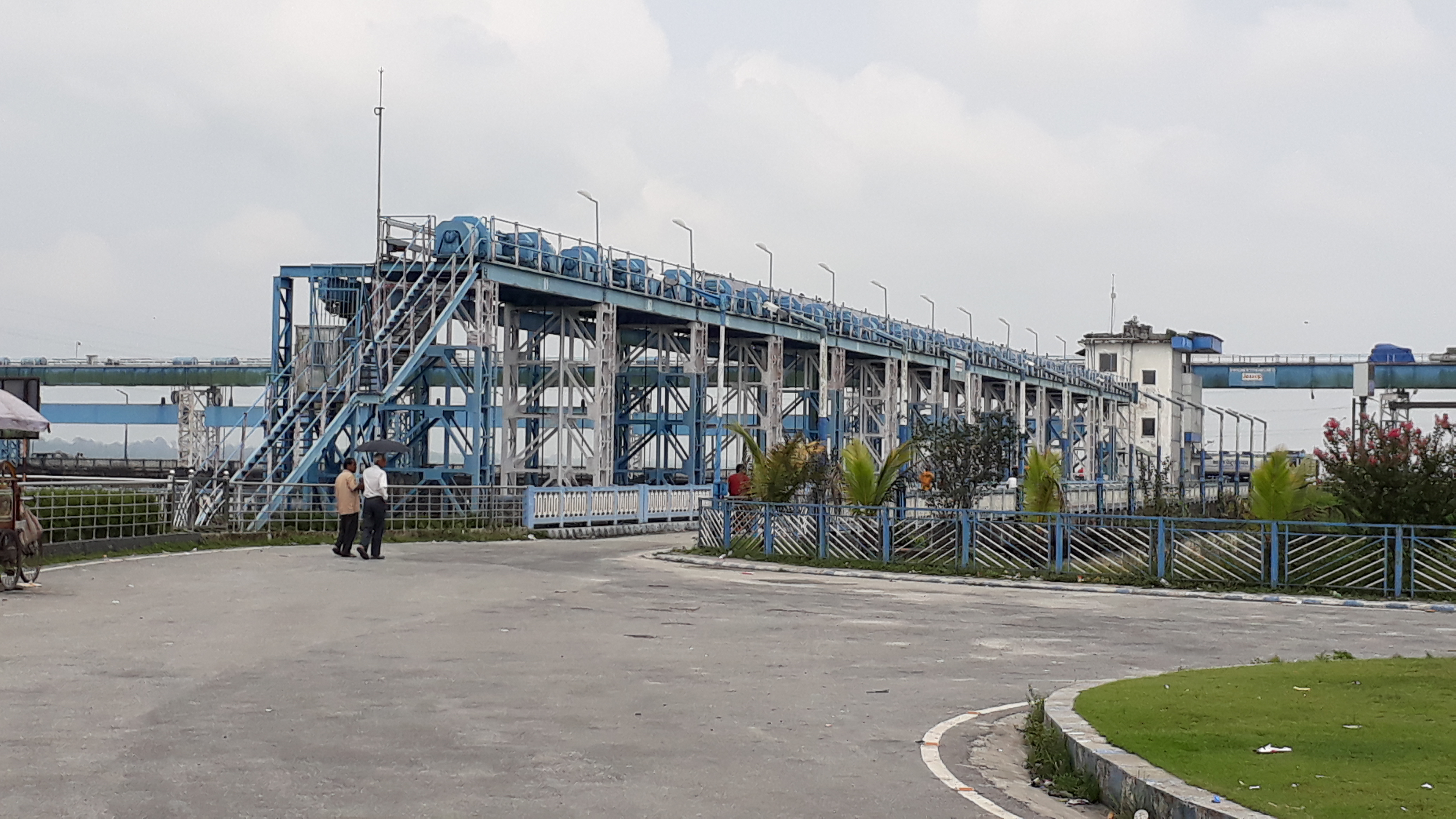
Hydroelectric projects and barrages


India has an estimated total hydroelectric power potential of 84 GW (at 60% load factor). Of this, Sikkim's potential share is 2.9%, or about 4.29 GW. As of 2010, 13.9% (594 MW) of Sikkim's potential had been implemented and was under operation, 44.8% is under implementation (1919 MW), and another 41.3% (1773 MW) is yet to be examined from environment and engineering design perspective.[11]
The successfully completed major projects and dams are:
- Teesta -V dam, the largest project so far, was completed in 2007 on Teesta in Dikchu, East Sikkim district. Its height is 87 metres (285 ft) and its length is 176 metres (577 ft). It generates 510 MW hydroelectric power and assists flood control.[12]
- Rangit III hydroelectric project was completed in 2000 on Greater Rangit River which is a tributary of Teesta River. The catchment area of Rangit III dam is 979 square kilometres (378 sq mi) and the dam is 47 metres (154 ft) high. The project has 60 MW generation capacity, and is already online.[13]
The other three completed projects are significantly smaller and minor—Lower Lagyap, Upper Rongni Chhu and Mayang Chhu projects.[11]
Water sharing challenge
Disputes over the appropriate allocation and development of the water resources of the river have remained a subject of conflict between India and Bangladesh for almost 35 years, with several bilateral agreements and rounds of talks failing to produce results.[14][15][16]
Negotiations have been going on since 1983.[17][18][19] In 1983, a temporary solution had been worked out— Bangladesh would get 36%, India would get 39% while the rest of the water remained unallocated.[18] Both countries signed a water sharing treaty in 1996 which would look into water sharing between the two countries in general following the Ganges water dispute.[18] The water sharing remains a challenge.[18]
Seismic concerns
Teesta river area is in the seismically active Zone-V and has experienced micro-seismic activity. According to India's Ministry of Environment & Forests, the Teesta river dam projects have been approved with the requirement that they adopt suitable seismic coefficient in the design for the dam, tunnel, surge shaft and power house. The projects are cascaded over the length of the river, do not store large amounts water, have small reservoirs, and therefore the projects are expected to have very low risk from the reservoir induced seismicity in the area.[11]
Climate and tectonics
The Teesta river has preserved good imprints of climatic and tectonics along its valleys and catchments. The interrelationship between climate, erosion, deposition and tectonic activities is not properly understood to date. These are being studied.[3][20][21]
See also
References
- Mullick, M. R. A.; Babel, M. S. & Perret, S. R. (2011). "Discharge‐based economic valuation of irrigation water: Evidence from the Teesta River, Bangladesh". Irrigation and Drainage. 60 (4): 481−492. doi:10.1002/ird.597.
- Rahaman, M. M. & Mamun, A. A. (2020). "Hydropower development along Teesta river basin: opportunities for cooperation". Water Policy. 22 (4): 641–657. doi:10.2166/wp.2020.136.
- Meetei, L. I.; Pattanayak, S. K.; Bhaskar, A.; Pandit, M. K.; Tandon, S. K. (2007). "Climatic imprints in Quaternary valley fill deposits of the middle Teesta valley, Sikkim Himalaya". Quaternary International. 159 (1): 32–46. Bibcode:2007QuInt.159...32M. doi:10.1016/j.quaint.2006.08.018.
- Chaudhuri, Samita; Chaudhuri, Utpal (2015). And the Teesta Flows... Niyogi Books. p. 188. ISBN 978-93-83098-70-5.
- Joshi, H. G. (2004). Sikkim: Past and Present. Mittal Publications. p. 1. ISBN 978-81-7099-932-4. Retrieved 8 September 2009.
- Emran Hossain; Rezaul Karim Manik (8 September 2021). "Fresh flood feared in Bangladesh as India opens Gajoldoba again". New Age. Lalmonirhat. Retrieved 2 November 2021.
- Liakat Ali Badal (28 August 2021). "Nearly 2,000 families stranded as flood hits 15 Rangpur villages". Dhaka Tribune. Retrieved 2 November 2021.
- Majumdar, R. C. (1971). History of Ancient Bengal. Calcutta: G. Bhardwaj & Co. pp. 4–5. OCLC 961157849.
- Majumdar, S.C. (1941). Rivers of the Bengal Delta. pp. 52
- Bari, M F. (2012). "Barrage". Banglapedia: National Encyclopedia of Bangladesh. Asiatic Society of Bangladesh.
- "Environmental Impact Assessment of Ting Ting H.E. Project, Sikkim" (PDF). Ministry of Environment, Forest, and Climate Change. Archived from the original (PDF) on 20 October 2014.
- "Teesta-V D01535". India Water Resources Information System. National Remote Sensing Centre. Government of India. Archived from the original on 18 October 2014. Retrieved 15 June 2014.
- "RANGIT-III HE PROJECT - NHPC(SIKKIM) -". India Water Resources Information System. National Remote Sensing Centre. Government of India. Retrieved 22 March 2018.
- Sarkar, SK (3 April 2017). "Sharing the Teesta". The Statesman (Opinion). Retrieved 7 April 2017.
- Ray, Aparna (8 June 2012). "India, Bangladesh: Water Disputes and Teesta River Diplomacy". Global Voices. Retrieved 7 April 2017.
- Bhattacharjee, Joyeeta (10 December 2016). "India and Bangladesh need to bring the Teesta out of muddled waters". Hindustan Times. Retrieved 7 April 2017.
- "The Teesta river dispute explained in 10 points". The Times of India. 9 April 2017. Retrieved 2 November 2021.
- Ranjan, Amit (2020). "3: River water disputes between India and Bangladesh. The Teesta Rivers waters dispute.". Contested Waters: India's Transboundary River Water Disputes in South Asia. Taylor & Francis. ISBN 978-1-000-17390-1.
- Gambhir, Mohak (31 May 2021). "Teesta Dispute and India-Bangladesh Relations". Center For Land Warfare Studies (CLAWS). Retrieved 2 November 2021.
- Mukul, Malay (2000). "The geometry and kinematics of the Main Boundary Thrust and related neotectonics in the Darjiling Himalayan fold-and-thrust belt, West Bengal, India". Journal of Structural Geology. 22 (9): 1261–1283. Bibcode:2000JSG....22.1261M. doi:10.1016/S0191-8141(00)00032-8.
- Mukul, Malay; Jaiswal, M.; Singhvi, A. K. (November 2007). "Timing of recent out-of-sequence active deformation in the frontal Himalayan wedge: Insights from the Darjiling sub-Himalaya, India". Geology. The Geological Society of America. 35 (11): 999–1002. Bibcode:2007Geo....35..999M. doi:10.1130/G23869A.1.
External links
- Tista River at GEOnet Names Server
- Mesbah-us-Saleheen (2012), "Tista River", in Sirajul Islam and Ahmed A. Jamal (ed.), Banglapedia: National Encyclopedia of Bangladesh (Second ed.), Asiatic Society of Bangladesh
На других языках
[de] Tista
Die Tista (Bengalisch: .mw-parser-output .Beng{font-size:110%}তিস্তা, Tistā; anglisierend auch Teesta) ist ein 430 km (davon 130 km in Bangladesh) langer rechter Nebenfluss des unteren Brahmaputra.- [en] Teesta River
[es] Río Tista
El río Tista (en nepalí, टिस्टा खोला, TisTa Khola; en bengalí: তিস্তা, Tistā; en inglés Teesta) es un río que discurre por la parte nororiental de la India y Bangladés, un afluente del río Brahmaputra.[it] Tista
Il fiume Tista (in bengalese: তিস্তা, Tistā; anglicizzato in Teesta), è un corso d'acqua che attraversa le regioni indiane del Sikkim e del Bengala Occidentale nella zona dell'Himalaya per poi, giunto in Bangladesh, confluire nel fiume Jamuna, il ramo principale del Brahmaputra.[ru] Тиста
Тиста (англ. Teesta, непальск. टिस्ता खोला — «Тиста Кхола», бенг. তিস্তা নদী — «Тиста Ноди»), река в Индии и Бангладеш, приток Брахмапутры. Главная водная артерия бывшего княжества, ныне индийского штата Сикким, протекает через весь штат, прорезав глубокую долину в Гималаях с собственным микроклиматом. На некотором протяжении образует границу между штатами Сикким и Западная Бенгалия, затем протекает по Западной Бенгалии и Бангладеш, где впадает в Брахмапутру.Другой контент может иметь иную лицензию. Перед использованием материалов сайта WikiSort.org внимательно изучите правила лицензирования конкретных элементов наполнения сайта.
WikiSort.org - проект по пересортировке и дополнению контента Википедии