geo.wikisort.org - River
A long-standing dispute exists between India and Bangladesh over the appropriate allocation, and development, of the water resources of the Ganges River, which flows from northern India into Bangladesh. The issue had remained a subject of conflict for almost 35 years, with several bilateral agreements and rounds of talks failing to produce results.
However, a comprehensive bilateral treaty was signed by Indian Prime Minister H. D. Deve Gowda and Bangladeshi Prime Minister Sheikh Hasina Wajed on 12 December 1996 in the Indian capital New Delhi. The treaty established a 30-year water-sharing arrangement and recognised Bangladesh's rights as a lower-level riparian.[1][2][3]
Background
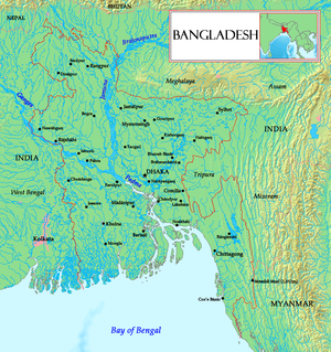
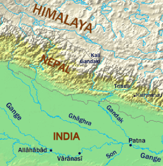
Descending from India's northern plains, the Ganges river forms a boundary of 129 kilometres between India and Bangladesh and flows for 113 km in Bangladesh. At Pakaur in India, the river begins its attrition with the branching away of its first distributary, the Bhagirathi River, which goes on to form the Hooghly River. About 10 kilometres from the border with Bangladesh the Farakka Barrage, built in 1974, controls the flow of the Ganges, diverting some of the water into a feeder canal linking the Hooghly to keep it relatively silt-free.[4]
After entering Bangladesh, the main branch of the Ganges is known as the Padma River until it is joined by the Jamuna River, the largest distributary of the Brahmaputra River, which descends from Assam and Northeast India. Further downstream, the Ganges is fed by the Meghna River, the second-largest distributary of the Brahmaputra, and takes on the Meghna's name as it enters the Meghna estuary. Fanning out into the 350 km wide Ganges Delta, it finally empties into the Bay of Bengal. A total of 54 rivers flow into Bangladesh from India.[5]
Efforts at resolution
Indian Prime Minister Indira Gandhi and Bangladesh's founding leader Sheikh Mujibur Rahman signed the wide-ranging Indo-Bangladeshi Treaty of Friendship, Cooperation and Peace on 19 March 1972;[4] as per the treaty, the two nations established a Joint River Commission to work for the common interests and sharing of water resources, irrigation, floods and cyclones control.[2]
Farakka Barrage
The Farakka Barrage is a dam on the Bhagirathi River located in the Indian state of West Bengal, roughly 10 km (6.2 mi) from the border with Bangladesh. India uses it to control the flow of the Ganges River. The dam was built to divert Ganges River water into the Hooghly River during the dry season, from January to June, to flush out the accumulating silt which in the 1950s and 1960s was a problem at Kolkata Port on the Hooghly River.[4] Bangladesh claimed that its rivers were drying up because of excess drawing of water by India.[5] In May 1974 a joint declaration was issued to resolve the water–sharing issue before the Farakka Barrage began operation.[3] This was followed by an interim agreement in 1975 to allow India to operate the feeder canals of the Barrage for short periods.[1][2]
However, India withdrew from the process of negotiations by September 1976 as both nations grew apart after the assassination of Sheikh Mujibur Rahman, the President of Bangladesh, in August 1975 during a military coup d'état, and the related establishment of military rule in Bangladesh.[4] Bangladesh protested India's unilateral action at a summit of the Non-Aligned Movement (NAM), and at the 31st session of the United Nations General Assembly.[2] At the urging of other nations and the U.N., both India and Bangladesh agreed to resume dialogue, but with no results.[2]
Temporary agreements
Bilateral relations had improved in 1977 during the governments of the then-Prime Minister Morarji Desai of India and the then-President Ziaur Rahman of Bangladesh;[4] in 1977 both leaders signed a 5-year treaty on water-sharing, but this expired in 1982 without being renewed.[1][2][3]
Bangladesh attempted to internationalise the affair by lobbying the U.N. General Assembly and the South Asian Association for Regional Cooperation (SAARC) without any result.[1]
1996 Treaty

The formation of an Awami League government in 1996 under Sheikh Hasina Wajed, the daughter of Sheikh Mujib, led to a fresh thaw in relations and negotiations restarted. Both countries leaders met in the Indian capital on 12 December 1996 and signed a 30-year, comprehensive treaty.[1][2][3]
As per the 1996 treaty for sharing the Ganges waters at Farakka , the division is as follows:[6]
| Availability at Farakka | Share of India | Share of Bangladesh |
|---|---|---|
| 70,000 cusecs or less | 50% | 50% |
| 70,000 – 75,000 cusecs | Balance of the flow | 35,000 cusecs |
| 75,000 cusecs or more | 40,000 cusecs | Balance of the flow |
Both nations were able to co-operate in harnessing the water resources; the treaty also permits the construction of barrages and irrigation projects in Kushtia and the Gorai-Madhumati River in Bangladesh, draining the south-western districts and thus preserving the environment, natural and economic resources.[2]
Assessment
The 1996 treaty established a long-term solution and considerably eased strains in Indo-Bangladeshi relations.[1][3] The 1996 treaty has been attacked by the Awami League's (AL) main rival, the Bangladesh Nationalist Party (BNP), which is regarded as hostile to India, but BNP did not renege from the treaty when it came to power in 2001. The BNP and other Bangladeshi political factions allege that India is drawing excessive water and the amount allocated to Bangladesh is unjust and insufficient.[1][5] India in turn complains that the water allocated to Bangladesh leaves it with less water than necessary for the functioning of Kolkata Port and the National Thermal Power Corporation in Farakka.[5]
Other critics have also stressed environmental reasons for India to reconsider its drawing of water at Farraka. Alarming increases in deforestation and erosion at the upper levels of the Ganges River increases the deposition of silt at the lower level, which is already measured at 2 million tonnes annually, along with increased salinity, have led to desertification.[7] In Bangladesh, the diversion has raised salinity levels, contaminated fisheries, hindered navigation and posed a threat to water quality and public health.[8] Such silt levels are believed to be adversely affecting the Hooghly River and Kolkata Port.[1]
References
- Robie I. Samanta Roy (November 1997). "India-Bangladesh Water Dispute". American.edu. Archived from the original on 28 April 2008. Retrieved 30 May 2008.
- Haq, Enamul (2012). "Ganges Water Sharing". In Islam, Sirajul; Jamal, Ahmed A. (eds.). Banglapedia: National Encyclopedia of Bangladesh (Second ed.). Asiatic Society of Bangladesh.
- Saswati Chanda; Alok Kumar Gupta (24 January 2000). "The Ganges Water Sharing Treaty: Genesis & Significance". Institute of Peace and Conflict Studies. Retrieved 30 May 2008.
- Heitzman, James; Worden, Robert, eds. (1989). "India". Bangladesh: A Country Study. Washington, D.C.: Federal Research Division, Library of Congress. pp. 188–191.
- Sudha Ramachandran (8 June 2006). India, Bangladesh fight against the current. Asia Times. Accessed 30 May 2008.
- "Treaty between the Government of the Republic of India and the Government of the People's Republic of Bangladesh on sharing of the Ganga/ Ganges waters at Farakka" (PDF). ssvk. Retrieved 12 August 2017.
- Islam, Nahid (1992). "Indo-Bangladesh Common Rivers: The Impact on Bangladesh". Contemporary South Asia. 1 (2): 203–225. doi:10.1080/09584939208719682.
- Wolf, Aaron T. (2001). "Water and Human Security" (PDF). Journal of Contemporary Water Research and Education. 118: 31.
| Diplomatic posts |
|
|---|---|
| Diplomacy |
|
| Incidents |
|
| Military relations |
|
| Initiatives |
|
| Transport |
|
| Related |
|
Другой контент может иметь иную лицензию. Перед использованием материалов сайта WikiSort.org внимательно изучите правила лицензирования конкретных элементов наполнения сайта.
WikiSort.org - проект по пересортировке и дополнению контента Википедии