geo.wikisort.org - River
Shitalakshya River (Bengali: শীতলক্ষ্যা নদী pronounced: Shitalokkha Nodi) (also known as Lakshymā River) is a distributary of the Brahmaputra. A portion of its upper course is known as Banar River or Banor River.[citation needed] In the Shitalakshya's initial stages, it flows in a southwest direction and then east of the city of Narayanganj in central Bangladesh until it merges with the Dhaleswari near Kalagachhiya. The river is about 110 kilometres (68 mi) long and at it widest, near Narayanganj, it is 300 metres (980 ft) across. Its flow, measured at Demra, has reached 74 cubic metres per second (2,600 cu ft/s). It remains navigable year round.[1] The river flows through Gazipur district forming its border with Narsingdi for some distance and then through Narayanganj District.
| Shitalakshya River | |
|---|---|
 Shitalakhya River near Narayanganj | |
 | |
| Location | |
| Country | Bangladesh |
| City | Narayanganj |
| Physical characteristics | |
| Length | 110 km (68 mi) |
| Discharge | |
| • location | Meghna River |
The river's maximum depth is 21 metres (70 ft) and average depth is 10 metres (33 ft).
Course
The Shitalakhya branches off the Old Brahmaputra and flows through the eastern part of Dhaka District almost parallel to the Old Brahmaputra. It passes by Narayanganj and joins the Dhaleshwari River.[2]
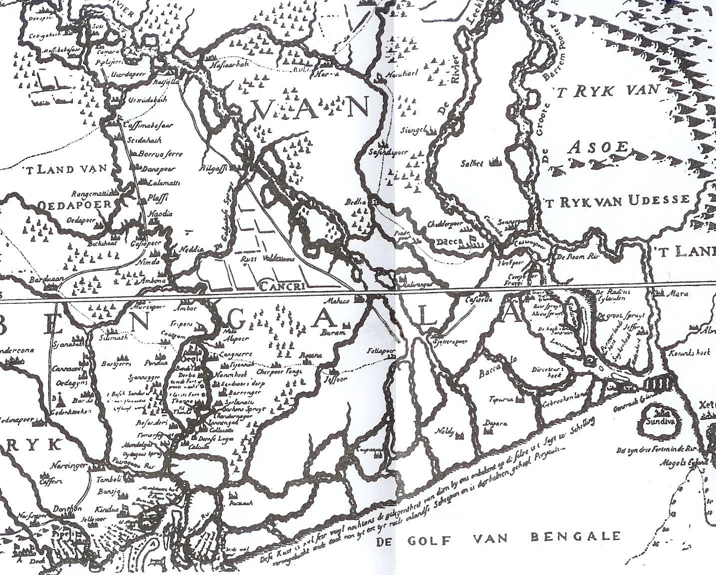
In Van den Brouck's map, the river is marked as Lecki, flowing west of Barrempooter (Brahmaputra). In Van den Brouck's time (1660), it was a large and swift flowing river. It was so till the early 19th century.[3] There, however, are some reservations about the accuracy of Van den Brouck's map.
Historical importance
Sonargaon, a former capital of the region, stood on the banks of the Shitalakhhya. A fort was built by Isa Khan, a former ruler of the area, on its banks. It is believed that it was connected with Lalbagh Fort in Dhaka through a tunnel. Sonakanda Fort, also on the river, was built to counter Magh and Portuguese pirates. There are several historical mosques on its banks – Bandarshahi mosque (built in 1481 by Baba Saleh), Kadam Rasul mosque (containing the footprints of Muhammad), Mariamer masjid (built by Shaista Khan) etc.[4]
Economic importance
The Shitalakshya River was once an important center for the muslin industry.[1] Even today, there are centres of artistic weaving on its banks. There also are a number of industrial units on its banks, including the Adamjee Jute Mills. Thermal power houses are located along the river at Palash (north of Ghorashal) and at Siddhirganj.[1] Industrial affluent dumped into the river resulting in high levels of pollution is a cause for concern.[5]

There is a river port in Narayanganj.[1] Numerous launches move out along the river to different parts of Bangladesh. The government has approved construction of a container terminal on the river Shitalakhya with foreign investment.[6]
References
- Md Mahbub Murshed (2012). "Shitalakshya River". In Sirajul Islam and Ahmed A. Jamal (ed.). Banglapedia: National Encyclopedia of Bangladesh (Second ed.). Asiatic Society of Bangladesh.
- Majumdar, R. C. (1971). History of Ancient Bengal. Calcutta: G. Bhardwaj & Co. p. 4. OCLC 96115784.
- Roy, Niharranjan, Bangalir Itihas, Adi Parba, (in Bengali), first published 1972, reprint 2005, p. 86, Dey’s Publishing, 13 Bankim Chatterjee Street, Kolkata, ISBN 81-7079-270-3
- Khokon, Leaquat Hossain, 64 Jela Bhraman, 2007, pp.14-15, Anindya Prokash, Dhaka, ISBN 984-8740-19-8
- Alam, Mohammad Naushad; Elahi, Fazle; Didar-Ul-Alam, Md. "Risk and Water Quality Assessment overview of River Sitalakhya in Bangladesh". Academic Open Internet Journal. Technical College, Bourgas. ISSN 1311-4360. Retrieved 2007-11-22.
- "Govt okays container terminal on Shitalakhya". The Independent. Dhaka. UNB. Archived from the original on 2007-08-14. Retrieved 2007-11-17.
На других языках
- [en] Shitalakshya River
[es] Shitalakshya
El río Shitalakshya (en bengalí: শীতলক্ষ্যা নদী; con otro nombre Río Lakhya) es un ramal del río Brahmaputra. Desde su nacimiento fluye en dirección suroeste para dejar luego al este la ciudad de Narayanganj, en la región central de Bangladés hasta que se une con el río Dhaleswari cerca de Kalagachhiya. Una parte de su curso superior se conoce también como río Banar. El río tiene unos 110 km de largo y en su parte más ancha, cerca de Narayanganj tiene 300 metros de orilla a orilla. Su mayor caudal en la desembocadura en Demra ha sido 73.624.200 litros. El río es navegable durante todo el año.[1] El río discurre por el distrito de Ghazipur, siendo la frontera natural con el distrito de Narsingdi durante varios kilómetros para adentrarse luego en el distrito de Narayanganj.[ru] Шиталакшья
Шиталакшья — река, протекающая на юго-востоке Бангладеш.Другой контент может иметь иную лицензию. Перед использованием материалов сайта WikiSort.org внимательно изучите правила лицензирования конкретных элементов наполнения сайта.
WikiSort.org - проект по пересортировке и дополнению контента Википедии