geo.wikisort.org - River
Kadalundi River (Kadalundipuzha) is one of the four major rivers flowing through Malappuram district in the Indian state of Kerala. The other three are the Chaliyar, the Bharathappuzha and the Tirur River.[1] This rain-fed river is 130 kilometres (81 mi) long and is one of the most important rivers in the district.[2] Kadalundi River is also the sixth longest River in Kerala. Kadalundi River passes through [Karuvarakundu, Tuvvur [Melattur, Kerala|Melattur]], Pandikkad, Manjeri, Malappuram, Panakkad, Parappur, Vengara, Tirurangadi, Parappanangadi, Vallikkunnu, and empties itself into Arabian sea at Kadalundi Nagaram in Vallikkunnu on the northwestern border of the district.[3] It is formed by the confluence of the Olippuzha River and the Veliyar River.[3] The Kadalundi originates from the Western Ghats at the western border of the Silent Valley and flows through the district of Malappuram.[3] It has two main tributaries namely Olipuzha and Veliyar.[3] Olipuzha and Veliyar merges together to become Kadalundi River near Melattur.[3] Kadalundi River traverses through the historical regions of Eranad and Valluvanad.[3] The Kadalundi River drains an area of 1274 km² and has a length of 120 km.[4] The ancient port of Tyndis, which was the second-largest trading port of Chera dynasty, only after to Muziris, is identified with the mouth of this river at Vallikunnu.[5] The Kadalundi Bird Sanctuary spreads over a cluster of islands where the Kadalundipuzha River flows into the Arabian Sea.[3] There are over a hundred species of native birds and around 60 species of migratory birds in large numbers annually.[6]
| Kadalundi കടലുണ്ടി നദി | |
|---|---|
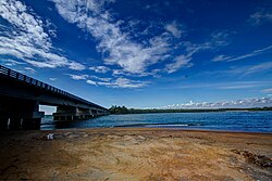
 Kadalundi bridge | |
| Location | |
| Country | India |
| State | Kerala |
| Physical characteristics | |
| Source | Cherakomban Mala |
| • location | Kerala, India |
| • coordinates | 11°08′N 76°28′E |
| • elevation | 1,160 m (3,810 ft) |
| Mouth | Arabian Sea |
• location | Kerala, India |
• coordinates | 11°07′N 75°49′E |
• elevation | 0 m (0 ft) |
| Length | 130 km (81 mi) |
| Basin size | 1,122 km2 (433 sq mi) |
| Discharge | |
| • location | mouth |
| • average | 36 m3/s (1,300 cu ft/s) |


Cultural Significance


The 16th century Malayalam poet and the author of Jnanappana, Poonthanam Nambudiri was born at Keezhattur near Perinthalmanna, on the bank of Kadalundi River.[7][8][9]
Kerala Varma Valiya Koyi Thampuran (Kerala Kalidasan), Raja Raja Varma (Kerala Panini) and Raja Ravi Varma (Famous Painter) were from different branches of Parappanad Royal Family who migrated from Parappanangadi to Harippad, Changanassery, Mavelikkara and Kilimanoor.[10] Parappanangadi also lies on the bank of Kadalundi River.[9] The Chief Editor of the daily "The Hindu" (1898 to 1905) and Founder Chief Editor of "The Indian Patriot" Divan Bahadur Cozhisseri Karunakara Menon (1863–1922) was also from Parappanangadi.[11] O. Chandu Menon wrote his novels "Indulekha" and "Saradha" while he was the judge at Parappanangadi Munciff Court. Indulekha is also the first Major Novel written in Malayalam language.
See also
- Kadalundi Bird Sanctuary
- Kadalundi train derailment
- Vallikkunnu
References
- "Malappuram District Rivers". Malappuram.net. Retrieved 13 October 2006.
- "Kerala Government - General Features". Official Website of Kerala Government. Archived from the original on 2 November 2006. Retrieved 13 October 2006.
- "Rivers in Malappuram district". malappuram.nic.in. Retrieved 23 November 2019.
- NIC Malappuram website
- A Survey of Kerala History, A. Shreedhara Menon
- "Wild Life Tourism in Kerala". keralaeverything.com. Retrieved 13 October 2006.
- I K K Menon. FOLK TALES OF KERALA. Publications Division Ministry of Information & Broadcasting Government of India. pp. 194–. ISBN 978-81-230-2188-1.
- K. Narayanan (1972). District Census Handbook - Malappuram (Part-C) - 1971 (PDF). Thiruvananthapuram: Directorate of Census Operations, Kerala. p. 3.
- Directorate of Census Operations, Kerala. District Census Handbook, Malappuram (PDF). Thiruvananthapuram: Directorate of Census Operations, Kerala.
- Visakham thirunal. [Place of publication not identified]: Duc. 2012. ISBN 978-613-9-12064-2. OCLC 940373421.
- Some Madras Leaders. Allahabad Printed at Standard Press. 1922.
External links
| Wikimedia Commons has media related to Kadalundi River. |
- "About the Rivers of Kerala". All Kerala River Protection Council. Retrieved 10 September 2009.
На других языках
- [en] Kadalundi River
[ru] Кадалунди
Кадалунди (малаялам: കടലുണ്ടിപ്പുഴ) — одна из крупнейших рек индийского штата Керала. Берёт своё начало на склонах Западных Гхат, течёт через округ Малаппурам и впадает в Лаккадивское море. Основные притоки: Олипужа и Велияр. Длина реки составляет около 130 км, площадь бассейна: 1122 км²[1].Другой контент может иметь иную лицензию. Перед использованием материалов сайта WikiSort.org внимательно изучите правила лицензирования конкретных элементов наполнения сайта.
WikiSort.org - проект по пересортировке и дополнению контента Википедии
