geo.wikisort.org - River
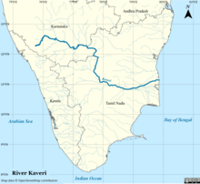
The Kaveri (also known as Cauvery, the anglicized name) is one of the major Indian rivers flowing through the states of Karnataka and Tamil Nadu. The Kaveri river rises at Talakaveri in the Brahmagiri range in the Western Ghats, Kodagu district of the state of Karnataka, at an elevation of 1,341 m above mean sea level and flows for about 800 km before its outfall into the Bay of Bengal. It reaches the sea in Poompuhar in Mayiladuthurai district. It is the third largest river – after Godavari and Krishna – in southern India, and the largest in the State of Tamil Nadu, which, on its course, bisects the state into north and south. In ancient Tamil literature, the river was also called Ponni (the golden maid, in reference to the fine silt it deposits).[3][4][5]
This article needs additional citations for verification. (June 2013) |
| Kaveri Cauvery | |
|---|---|
 Kaveri river flowing in Srirangapatna | |
 Map of the Kaveri river basin | |
| Location | |
| Country | India |
| States | Karnataka, Tamil Nadu, Kerala, Puducherry |
| Region | South India |
| Origin | Kodagu, Karnataka |
| Physical characteristics | |
| Source | Talakaveri, Kodagu, Western Ghats, Karnataka |
| • location | Karnataka, India |
| • coordinates | 12°23′N 75°29′E |
| • elevation | 1,341 m (4,400 ft) |
| Mouth | Bay of Bengal |
• location | Poompuhar, Tamil Nadu, India |
• coordinates | 11°21′40″N 79°49′46″E |
• elevation | 0 m (0 ft) |
| Length | 805 km (500 mi)[1] |
| Basin size | 81,155 km2 (31,334 sq mi) |
| Discharge | |
| • average | 677 m3/s (23,900 cu ft/s) |
| Discharge | |
| • location | Grand Anicut (South)[2] |
| • average | 400.716 m3/s (14,151.2 cu ft/s) |
| Basin features | |
| Tributaries | |
| • left | Harangi, Hemavati, Shimsha, Arkavathy |
| • right | Lakshmana Tirtha, Kabini, Bhavani, Noyyal, Amaravati, Moyar |
The Kaveri is a sacred river to the people of South India and is worshipped as the Goddess Kaveriamma. It is considered to be among the seven holy rivers of India.[6] It is extensively used for agriculture in both Karnataka and Tamil Nadu.
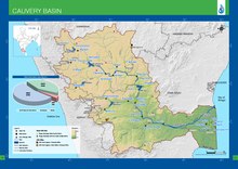
The catchment area of the Kaveri basin is estimated to be 81,155 square kilometres (31,334 sq mi) with many tributaries including Harangi, Hemavati, Kabini, Bhavani, Lakshmana Tirtha, Noyyal and Arkavati. The river basin covers three states and a Union Territory as follows: Tamil Nadu, 43,868 square kilometres (16,938 sq mi); Karnataka, 34,273 square kilometres (13,233 sq mi); Kerala, 2,866 square kilometres (1,107 sq mi), and Puducherry, 148 square kilometres (57 sq mi).[7] In Chamarajanagar district it forms the island of Shivanasamudra, on either side of which are the scenic Shivanasamudra Falls that descend about 100 metres (330 ft).[8] The river is the source for an extensive irrigation system and for hydroelectric power.[9] The river has supported irrigated agriculture for centuries and served as the lifeblood of the ancient kingdoms and modern cities of southern India. Access to the river's waters has pitted Indian states against each other for decades. It was profusely described in the Tamil Sangam literature and is held in great reverence in Hinduism. The Kaveri river delta is a thickly populated delta, one which is frequently affected by tropical cyclones formed in the Bay of Bengal.
Etymology
Dravidian
- The etymology of the river was derived from the Sankethi word for "river", ಕಾವೇರಿ காவிரி (kāviri), as this is the major river for the Sankethi people that live along its waters. The word is from the Dravidian/Tamil root words "ka" and "viri", "கா" and "விரி", which roughly translates to "branching into fields/forests", due to the river's multiple divergences in the delta region.[10]
- Another likely Dravidian-origin of the word is from kāv, meaning "forest", and ēri meaning "a large water body".
Sanskrit
- Another theory suggests that Kāvēri is a Sanskrit word, from Ka which means "of water" and Vēri can be translated as "whose body" in feminine. Thus Kāvēri is "she whose body is made of water".[citation needed]
Marudvṛdhā is another name for this river, meaning "the beloved of the Maruts".[11]
Course
After the river leaves the Kodagu hills and flows onto the Deccan plateau, it forms two islands in Mandya district's Srirangapatna and Shivanasamudra. First comes the Srirangapatna, which forms the sangam, and then comes Shivanasamudra. At Shivanasamudra the river drops 98 metres (320 ft), forming the famous Shivanasamudra Falls known separately as Gagana Chukki and Bhara Chukki.[12] Asia's first hydroelectric plant (built in 1902) was on the left falls and supplied power to the city of Bangalore.
In its course through Karnataka, the channel is interrupted by 12 "anekattu" (dams) for the purpose of irrigation. From the Anaikattu at Madadkatte, an artificial channel is diverted at a distance of 116 kilometres (72 mi), irrigating an area of 4,000 hectares (10,000 acres), and ultimately bringing its water supply to the town of Mandya.
3 km away from Srirangapatna, the Kaveri is the basis for the Ranganthittu Bird Sanctuary. Near Srirangapatna is also an aqueduct, the Bangara Doddi Nala, which was constructed in the 17th century by the Wodeyar maharaja of Mysore, Ranadhira Kantirava, in memory of his favourite consort. This aqueduct also served as a motorable bridge until 1964.The Kabini River tributary of Kaveri joins Kaveri at Tirumakudal Narasipura where triveni sangama takes place along with mythological river Spatika. The Moyar River is an east flowing river that originates in the Mudumalai, Bandipur, and Wayanad National Parks draining the Nilgiri Hills in Tamil Nadu and Karnataka and is one of the tributaries to the Kaveri River.
The river enters Tamil Nadu through Dharmapuri district leading to the flat plains where it meanders. It drops into the Hogenakkal Falls just before it arrives in the town of Hogenakkal in Tamil Nadu. The three minor tributaries, Palar, Chinnar and Thoppar enter into the Kaveri on her course, above Stanley Reservoir in Mettur, where the dam has been constructed. It then flows further through the length of Erode district where the river Bhavani, running through the breadth of the district, merges with it. The confluence of the rivers Kaveri, Bhavani and Akash Ganga (mythological) is at the exact place of Bhavani, Tamil Nadu Kooduthurai or Tiriveni Sangamam, Northern part of Erode City.
While passing through Erode, two more tributaries merge. Thirumani Mutharu joins it in a village called Kududurai in Namakkal District. Noyyal and Amaravathi join it in Karur district and reaches Mayanur Dam, about 20 km east of Karur city. Here the river becomes wide, with a sandy bed, and flows in an eastern direction to enter Tiruchirappalli district It splits into two at upper Anicut about 14 kilometres (9 mi) west of Tiruchirappalli. The northern branch of the river is called the Kollidam at Ariyalur District while the southern branch retains the name Kaveri and then goes directly eastwards into Thanjavur District. These two rivers join again and form the Srirangam island that is a part of the city of Tiruchirapalli. The oldest functional dam[13] Grand Anicut or Kallanai was present at this place. From Thanjavur, the river splits and goes to few places in the Delta Kaveri.
Tributaries
- Harangi River
- Hemavati River
- Lakshmana Tirtha
- Amaravathi River
- Bhavani River
- Kabini River
- Noyyal River
- Arkavathi River
- Shimsha River
- Manimuttharu River
- Palar River (Kaveri basin)
- Moyar River
Irrigation
The primary uses of the Kaveri is providing water for irrigation, water for household consumption and the generation of electricity.
An estimate at the time of the first Five Year Plan puts the total flow of the Kaveri at 15 cubic kilometres (12,000,000 acre⋅ft), of which 60% was used for irrigation. [14]
The Torekadanahalli pumpstation sends 540 million litres (19,000,000 cu ft) per day of water from the Kaveri 100 kilometres (62 mi) to Bangalore.[15][16]
The hydroelectric plant built on the left of Sivanasamudra Falls on the Kaveri in 1902 was the first hydroelectric plant in Asia.[8]
The Krishna Raja Sagara Dam has a capacity of 49 tmc ft.[17] and the Mettur Dam which creates Stanley Reservoir has a capacity of 93.4 tmc ft. (thousand million cubic ft)
In August 2003, inflow into reservoirs in Karnataka was at a 29-year low, with a 58% shortfall.[18] Water stored in Krishna Raja Sagara amounted to only 4.6 tmc ft.[18]
In February 2020, Tamil Nadu assembly passed bill to declare Cauvery Delta as Protected Agricultural Zone, includes Thanjavur, Thirvarur, Nagapattinam and five blocks in Cuddalore and Pudukottai. The bill fails to include Tiruchirappalli, Ariyalur and Karur which are geographically included in the Cauvery Delta.[19]
Water sharing
Per the order of the Indian Supreme Court on 16 February 2018,[20] Karnataka will get 284.75 tmc ft, Tamil Nadu will get 404.25 tmc ft, Kerala will get 30 tmc ft and Puducherry will get 7 tmc ft. 10 tmc ft will be reserved for Environmental Protection and 4 tmc ft will be reserved for Inevitable Wastage into the Sea.[21]
Cauvery Water Management Authority (CWMA) and Cauvery Water Regulation Committee (CWRC) 2018
Acting on the Supreme Court's direction, the Centre constituted a Cauvery Water Management Authority (CWMA) on 1 June 2018 to address the dispute over sharing of river water among Tamil Nadu, Karnataka, Kerala and Puducherry.[22] The central government failed to adhere with the top court's deadline of within six weeks of deliverance of judgement.
On 16 February 2018, the apex court had directed the government to form the CWMA within six weeks in a verdict that marginally increased Karnataka's share of Cauvery water, reduced the allocation for Tamil Nadu and sought to settle the protracted water dispute between the two states.[23]
On 22 June 2018, despite opposition from Karnataka, the Central government constituted the Cauvery Water Regulation Committee (CWRC) as per the provisions in the Kaveri Management Scheme laid down by the Supreme Court.[24]
Central Water Commission chairman S. Masood Hussain will head the CWMA and chief engineer of the Central Water Commission Navin Kumar will be the first chairman of the CWRC. While the CWMA is an umbrella body, the CWRC will monitor water management on a day-to-day basis, including the water level and inflow and outflow of reservoirs in all the basin states.[24]
Kaveri Crater
Kaveri Crater is an area identified by scientists in India which appears to have been created by an asteroid impact that occurred around 800 to 550 million years ago. The area lying between Nilgiris and Kodaikanal is in the southern peninsular India. A study indicated that the Kaveri crater has a diameter of 120 kilometers. Because of the size of the crater, Kaveri crater can only be visualized through satellite images. The crater is the fourth largest crater in the world.

The region to the east of Palghat gap is of low elevation and nearly circular in shape. It forms a part of the Kaveri river basin. The predominantly gneissic terrain is surrounded by the charnockitic hill ranges, prominent among which are Nilgiris and Biligiriranga Hills to the north; and Anaimalai and Kodaikanal to the south. The charnockite massifs have a steep slope facing the circular feature and a gentler slope in the opposite direction. Fractures, faults and shear zones are noticed in many parts. The Bouguer anomaly in the gneissic terrain is elliptical in shape and positive, relative to the surrounding elevated region. The magnetic contours are also elliptical and the magnetic basement is deeper by about one kilometer compared with regions in the periphery. The shallow seismic velocity picture from Chennimalai to Palani indicates a graben structure. The velocity structure also depicts a 4-5 kilometer Moho up-warp near Chennimalai. Junction between the gneissic and charnockitic terrain and even beyond is marked by the presence of pseudotachylites and breccia. Field and petrographic studies indicate presence of suevite, planar deformation features (PDF), planar fractures, diaplectic glass of quartz and plagioclase and spherical inclusion in suevite. These evidences taken together point to an extraterrestrial impact that created a crater of approximately 120 kilometer in diameter. Several lines of indirect evidences point to Neoproterozoic age for the impact.[25][26][27]
See also
- List of rivers of India
- Kaveri Pushkaram
References
- "INTEGRATED HYDROLOGICAL DATA BOOK" (PDF). Central Water Commission, India. p. 92. Archived from the original (PDF) on 2 April 2016. Retrieved 13 November 2017.
- "Gauging Station - Data Summary". RivDis. Archived from the original on 4 October 2013. Retrieved 1 October 2013.
- "Daughter of Ponni". indianexpress. 27 April 2014. Retrieved 27 April 2014.
- "Cauvery Chronicles II: Ponni's Perish". newslaundry. Retrieved 8 February 2020.
- "The death of a river". millenniumpost. 11 June 2019. Retrieved 11 June 2019.
- "Cauvery basin: its culture, places of historical significance, birth place, climate, precipitation, catchment, tributaries, state-wise spread, landuse". www.indiawaterportal.org. Retrieved 12 May 2020.
- "INTEGRATED HYDROLOGICAL DATA BOOK" (PDF). Retrieved 6 September 2012.
- "World Waterfall Database". Archived from the original on 14 November 2006. Retrieved 9 November 2006.
- "Shivasamudram Falls". cauvery.com. Retrieved 11 November 2006.
- கணேசன், இரா (1974). அறிவியல் துறைச் சொல்லாக்க முறைகள் (in Tamil). புதுச்சேரி: இந்தியப் பல்கலைக்கழகத் தமிழாசிரியர் மன்ற ஆறாவது கருத்தரங்கு ஆய்வுக்கோவை, பாண்டிச்சேரி, தாகூர் அரசினர் கலைக்கல்லூரித் தமிழ்த்துறைச் சார்பு வெளியீடு. pp. 893, 895.
- "MW". www.sanskrit-lexicon.uni-koeln.de. Retrieved 18 July 2022.
- The Cauvery Trail : Kaveri has many religious and tourism spots between KRS and Mettur Archived 2 July 2014 at the Wayback Machine
- "The world's oldest dams still in use".
- "Chapter 26: Irrigation and power". 1st Five Year Plan. Planning Commission, Government of India. Archived from the original on 28 March 2019. Retrieved 1 July 2019.
- "PINCHme: Try products from leading brands for FREE!".
- "Archived copy" (PDF). www.tce.co.in. Archived from the original (PDF) on 20 March 2007. Retrieved 13 January 2022.
{{cite web}}: CS1 maint: archived copy as title (link) - "Corporation urged to chalk out water policy for Mysore city". The Hindu. Chennai, India. 26 March 2006. Archived from the original on 29 October 2006.
- "Cauvery reservoirs' inflow hits record low". Deccan Herald. Bangalore. 2 August 2003. Archived from the original on 6 April 2012. Retrieved 18 March 2011.
- "TN assembly passes bill to declare Cauvery Delta as Protected Agricultural Zone".
- "Archived copy" (PDF). Archived from the original (PDF) on 17 April 2018. Retrieved 24 July 2018.
{{cite web}}: CS1 maint: archived copy as title (link) - "Judgement Copy- SC verdict on Cauvery water dispute". Scribd.
- "Cauvery Water Management Scheme, 2018". Department of Water Resources, RD & GR.
- Rajagopal, Krishnadas (16 February 2018). "Supreme Court curtails Tamil Nadu's share of Cauvery water". The Hindu. ISSN 0971-751X. Retrieved 2 December 2019.
- "Cauvery dispute". www.thenewsminute.com. 23 June 2018. Retrieved 2 December 2019.
- Kumar, R. Krishna (19 January 2019). "Did an asteroid hit south India millions of years ago?". Thehindu.com. Retrieved 29 January 2019.
- "Kaveri Crater – An Impact Structure in the Precambrian Terrain of Southern India". ResearchGate.net. Retrieved 29 January 2019.
- Subrahmanya, K. R.; Prakash Narasimha, K. N. (1 October 2017). "Kaveri crater – An impact structure in the Precambrian terrain of Southern India". Journal of the Geological Society of India. 90 (4): 387–395. doi:10.1007/s12594-017-0733-5. S2CID 134717819.
External links
- Cauvery Presentation on the Cavery River
- Kaveri Pushkaralu
- Kaveri Pushkaram 2017
Authority control | |
|---|---|
| General |
|
| National libraries | |
На других языках
[de] Kaveri
Die Kaveri (Kannada: ಕಾವೇರಿ Kāvēri, Tamil: காவிரி Kāviri; früher auch anglisiert Cauvery, seltener Kavery) ist ein Fluss im Süden Indiens.- [en] Kaveri
[es] Río Kaveri
El río Kaveri (también transliterado como Cauvery o Kâverî) (en kannada, ಕಾವೇರಿ; en tamil, காவிரி) es un laro río de India que fluye en dirección sureste a través de los estados de Karnataka y Tamil Nadu hasta desaguar en el golfo de Bengala (océano Índico). Tiene una longitud de unos 800 km y drena una cuenca de 81 155 km². Está considerado uno de los siete ríos sagrados por los hindúes.[it] Kaveri
Il fiume Kaveri (tamil: காவிரி, kannada: ಕಾವೇರಿ) è uno dei più grandi fiumi dell'India, ed è considerato sacro dagli induisti.[ru] Кавери
Ка́вери[1] (там. காவிரி, англ. Kaveri, Cauvery) — одна из крупнейших рек в Индии, у индусов считается священной.Другой контент может иметь иную лицензию. Перед использованием материалов сайта WikiSort.org внимательно изучите правила лицензирования конкретных элементов наполнения сайта.
WikiSort.org - проект по пересортировке и дополнению контента Википедии