geo.wikisort.org - River
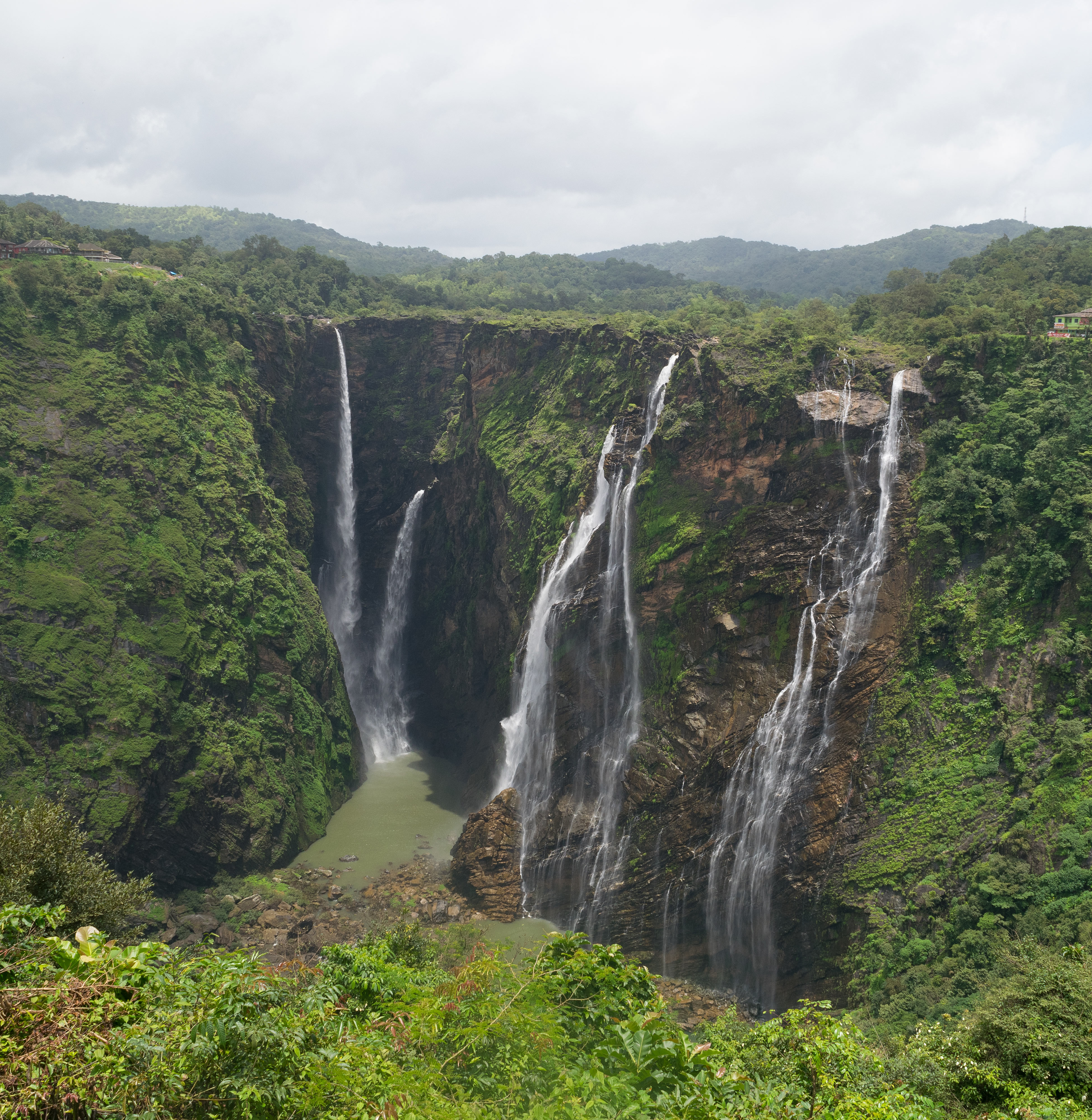
Jog Falls[6] is a waterfall on the Sharavati river located in the Western Ghats running between Uttara Kannada and Shimoga districts of Karnataka, India.[7] It is the third highest plunge waterfall in India.[8][9] It is a segmented waterfall which depends on rain and season to become a plunge waterfall. The falls are major attractions for tourists and is ranked 36th in the list of free-falling waterfalls, 490th in the world by list of waterfalls by total height, 128th in the list of single-drop waterfalls in the World by the waterfall database.[10]
| Jog Falls | |
|---|---|
| Joga Jalapatha Jogada gundi | |
 Jog Falls | |
 | |
| Location | Jog Fall,[1] [2] Karnataka |
| Type | Cataract, Segmented |
| Elevation | 488 m (1,601 ft) |
| Total height | 253 m (830 ft) [3] |
| Number of drops | 4
(Raja (king), Rani (queen), Roarer, Rocket) [4] |
| Longest drop | 254 m (833 ft) |
| Average width | 472 m (1,549 ft) |
| Watercourse | Sharavati River [5] |
| Average flow rate | 153 m3/s (5,400 cu ft/s) |
Description
Jog Falls is created by the Sharavati dropping 253 m (830 ft), making it the third-highest waterfall in India after the Nohkalikai Falls with a drop of 335 m (1,099 ft) in Meghalaya[11] and the Dudhsagar Falls with a drop of 310 m (1,020 ft) in Goa.
Sharavathi, a river which rises at Ambutirtha, next to Nonabur, in the Thirthahalli taluk takes a northwesterly course by Fatte petta, receives the Haridravati on the right below Pattaguppe and the Yenne Hole on the left above Barangi. Then, it bends to the west, precipitates itself down the Jog Falls (aka Gersoppa Falls), and passes the village of Gersoppa (properly Geru-Sappe), which is some 30 kilometres (19 mi) away, discharging into the Arabian Sea at Honnavar in Uttara Kannada.[12]
The Sharavathi, flowing over a very rocky bed about 250 yards (230 m) wide, reaches a tremendous chasm, 290 m (950 ft) deep, and the water comes down in four distinct falls, Raja, Rani, Roarer and Rocket.[13] The Raja Fall comes down in one unbroken column sheer to the depth of 250 m (830 ft). Halfway down, it is encountered by the Roarer, which precipitates itself into a vast cup and then rushes violently downwards to meet the Raja. The Rocket shoots downwards in a series of jets. The Rani moves quietly over the mountainside in a sheet of foam.[14] The Tourism Department has built steps from the viewpoint at the top, where the waterfall can be seen from across, to the bottom of the hill. There are approximately 1,400 steps made to reach the bottom of the hill.[15]
Significance
Associated with the waterfall is the nearby Linganamakki Dam across the Sharavati River.[16] The power station has been operational since 1948 and is of 120 MW capacity, one of the largest hydroelectric stations in India at that time and a small source of electric power for Karnataka now. The power station was previously named Krishna Rajendra hydro-electric project, after the King of Mysore at that time. The name was later changed to Mahatma Gandhi Hydro-electric Project. It was served by The Hirebhaskara dam until 1960. After 1960, due to the ideas of Mokshagundam Visvesvarayya, Linganmakki Dam has been used for power generation.[17]
Power
The hydro-electric project was conceived by the government of Mysore in mid-1943. A scheme to generate 64,000 horsepower at a cost of ₹358 lakh was designed.[18] The Power House on the right bank of the Gerusoppa dam consists of four Francis-type turbines coupled to the generating units of 60 MW each. The units are configured to operate at a design head of 47.5 mtrs. An outdoor switchyard is located between the toe of the dam and the power house. Power from the outdoor yard is evacuated through a 220 KV double circuit transmission line connected to the state grid at Talaguppa.
The capacity was increased subsequently and currently generates 240 MW of power.[19]
Transport connectivity

Jog Falls is situated Near Siddapura And Sagara city.
- Nearest railway stations[20] (distance to the location):
- Nearest bus station:
- Nearest centre for private road transport is Siddapura.[21]
- Nearest airport (aerial distance to the location):
- Domestic
- Hubli Airport (HBX): 133 km (83 mi)[22]
- International
- Bengaluru International Airport (BLR): 422 km (262 mi)[23]
- Mangalore International Airport (India) (formerly Bajpe Airport) (IXE): 200 km (120 mi)[24]
- Goa Airport (GOI): 264 km (164 mi)[25]
- Domestic
See also
- List of waterfalls of India
- Kodachadri
- Gudavi Bird Sanctuary
References
- Shivasuriya, Sanath (27 June 2021). "Tourists allowed to visit Jog Falls from June 28". SPECIAL CORRESPONDENT. The Hindu. Retrieved 9 August 2021.
- Shivasuriya, Sanath. "Soak In The Ultimate Bliss In The Lap Of Mother Nature As You Visit Jog Falls In Shimoga". whatshot.in. MANVI. Retrieved 9 August 2021.
- "Jogfalls Height". Jog Falls Official website.
- "Jog Falls". Jogfalls official website.
- "Jogfalls". Jog Falls Official website.
- Shivasuriya, Sanath (10 August 2021). "Jog Falls". karnatakatourism.org. Retrieved 10 August 2021.
{{cite web}}: CS1 maint: url-status (link) - Shivasuriya, Sanath (27 June 2021). "Tourists allowed to visit Jog Falls from June 28". SPECIAL CORRESPONDENT. The Hindu. Copyright© 2021, THG PUBLISHING PVT LTD. Retrieved 9 August 2021.
- "» Top 10 Highest Waterfalls in India". Retrieved 9 August 2021.
- Monsoon magic: Jog Falls, nature lovers' delight TRAVEL, IBN news channel, 10 August 2008
- Jog Falls World Waterfall Database: World's Tallest Waterfalls
- Gopal, Madan (1990). K.S. Gautam (ed.). India through the ages. Publication Division, Ministry of Information and Broadcasting, Government of India. p. 179.
- Shivasuriya, Sanath (9 August 2021). "Honnavar, Uttara Kannada District – The Story of a Small Town". karnataka.com. MADUR. Retrieved 9 August 2021.
{{cite web}}: CS1 maint: url-status (link) - Shivasuriya, Sanath (11 August 2019). "Jog Falls' viewing gallery stays empty as floods, landslips prevent visitors". Veerendra P M. The Hindu. Retrieved 9 August 2021.
- Shivasuriya, Sanath. "Jog Falls". dreantrails.in. Sandeep Ramavana. Retrieved 9 August 2021.
- "Jog Falls: the jewel of Sharavathi Valley". JLR Explore. Retrieved 28 August 2020.
- Karnataka Power Corporation Article Archived 19 January 2009 at the Wayback Machine
- Shivasuriya, Sanath (9 August 2021). "GERUSOPPA HYDRO ELECTRIC PROJECT". Karnataka Power Corporation Limited. Copyright © 2014. KPCL All Rights Reserved. Retrieved 9 August 2021.
{{cite web}}: CS1 maint: url-status (link) - "Jog Falls Hydro-Electric Project". The Indian Express. 2 July 1943. p. 4. Retrieved 12 April 2017.
- Shivasuriya, Sanath (9 August 2021). "GERUSOPPA HYDRO ELECTRIC PROJECT". karnatakapower.com. KPCL. Retrieved 9 August 2021.
{{cite web}}: CS1 maint: url-status (link) - Shivasuriya, Sanath. "Jog Falls Distance Bus Route Map". travel2karnataka.com. travel2karnataka.com. Retrieved 9 August 2021.
- Shivasuriya, Sanath. "How to Reach Jog Falls". www.holidify.com. © Holidify Travels Pvt Ltd.- All Right Reserved. Retrieved 9 August 2021.
- Shivasuriya, Sanath. "How to Reach Jog Falls". goibibo.com. © 2021 ibibogroup All rights reserved. Retrieved 9 August 2021.
- Shivasuriya, Sanath. "How to Reach Jog Falls". trawell.in. trawell. Retrieved 9 August 2021.
- Shivasuriya, Sanath. "Jog Falls – Witness the Majesty of Nature". karnataka.com. RAGGI MUDDE. Retrieved 9 August 2021.
- Shivasuriya, Sanath. "HOW TO GET FROM Goa Airport (GOI) to Jog Falls BY TRAIN, TAXI, CAR OR PLANE". Rome2rio. Rome2rio. Retrieved 9 August 2021.
External links
- Jog Falls on jogfalls.in. Jog Management Authority. Retrieved 16 November 2018.
- Jog Falls on Karnataka Government official Website
На других языках
[de] Jog-Wasserfälle
Die Jog Falls (Kannada: ಜೋಗ ಜಲಪಾತ Jōga jalapāt oder kurz ಜೋಗ Jōg) sind Wasserfälle im indischen Bundesstaat Karnataka im Distrikt Shivamogga. Der Fluss Sharavathi fällt hier 335 m in die Tiefe, damit sind die Jog Falls nach den Nohkalikai Falls die zweithöchsten freifallenden Wasserfälle Indiens.[1] Die in vier Kaskaden herabstürzenden Wasserfälle sind eine bedeutende Touristenattraktion. Sie werden auch Gerusoppe Falls, Gersoppa Falls und Jogada Gundi genannt.[2]- [en] Jog Falls
[es] Cataratas Jog
Las cataratas Jog (en inglés, Jog Falls; en canarés, ಜೋಗ ಜಲಪಾತ) son unas cataratas creadas por el río Sharavathi al precipitarse por una caída de 253 m de altura, las cascadas en picado o en el vacío más altas de la India.[1] Localizadas en el distrito de Shimoga, en el estado de Karnataka, estas caídas segmentadas son un importante atracción turística. También se les llama por otros nombres, como cataratas Gerusoppe, cataratas Gersoppa o Jogada Gundi.[2][ru] Герсоппа
Герсо́ппа (Йог) — водопад в Индии, в южной части гор Западные Гаты, расположенный на реке Шаравати (в 40 км от её устья).Другой контент может иметь иную лицензию. Перед использованием материалов сайта WikiSort.org внимательно изучите правила лицензирования конкретных элементов наполнения сайта.
WikiSort.org - проект по пересортировке и дополнению контента Википедии