geo.wikisort.org - River
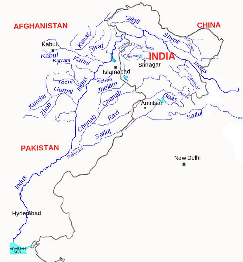
The Panjnad River (Punjabi and Urdu: پنجند) is a river at the extreme end of Bahawalpur district in Punjab, Pakistan. The name Panjnad means "five rivers", from Persian panj ("five") and Sanskrit nadī́ ("river").The Panjnad River is formed by successive confluence or merger of the five rivers of the Punjab, namely Jhelum, Chenab, Ravi, Beas and Sutlej.[1][2][3][4]
| Panjnad River | |
|---|---|
 | |
| Native name | پنجند (Punjabi) |
| Physical characteristics | |
| Mouth | Indus River |
• location | Mithankot |
• coordinates | 28°56′59.99″N 70°29′59.99″E |
| Length | 71 km (44 mi) |
| Basin size | 395,000 km2 (153,000 sq mi) |
| Discharge | |
| • location | Mithankot (near mouth) |
| • average | 2,500 m3/s (88,000 cu ft/s) |
| Basin features | |
| Tributaries | |
| • left | Chenab |
| • right | Sutlej |
Jhelum and Ravi join Chenab, Beas joins Sutlej, and then Sutlej and Chenab join to form Panjnad, 10 miles north of Uch Sharif in Muzaffar Garh district. The combined stream runs southwest for approximately 44 miles and joins the Indus River at Mithankot. The Indus Rver continues and then drains into the Arabian Sea. A barrage on Panjnad has been erected; it provides irrigation channels for Punjab and Sindh provinces south of the Sutlej and east of the Indus rivers.[1]
Beyond the confluence of the Indus and Panjnad rivers, the Indus River was known as Satnad (Sat = seven) carrying the waters of seven rivers including the Indus River, the five Punjab rivers, and the Kabul River.
References
- Panjnad River on Encyclopædia Britannica website Retrieved 16 January 2021
- Topography and Drainage of Pakistan on countrystudies.us website Retrieved 16 January 2021
- Panjnad River with major tributaries of Indus River
- "Trimmu and Panjnad Barrages Improvement Project: Rehabilitation and Upgrading of Panjnad Barrage - Asian Development Bank Project Document Page No. 25".
See also
- Panjnad
- Topography of Pakistan
This article about a location in Bahawalpur District, Punjab, Pakistan is a stub. You can help Wikipedia by expanding it. |
На других языках
[de] Panjnad
Der Panjnad (Urdu پنجند) ist ein Fluss im pakistanischen Bundesstaat Punjab.- [en] Panjnad River
[it] Panjnad
Il Panjnat è un fiume della provincia del Punjab, in Pakistan, formato, poco a valle di Uch, dalle successive confluenze dei fiumi Sutlej, Beās, Rāvi, Jhelum e Chenāb. Il Panjnad (letteralmente «Cinque Fiumi») scorre per 71 km verso sud-ovest fino alla sua confluenza con l'Indo nei pressi di Mithankot. Una diga sul Panjnad poco dopo la confluenza del Sutlej con il Chenāb fa parte del Sutlej Valley Project (un programma per l'irrigazione della valle del Sutlej).Другой контент может иметь иную лицензию. Перед использованием материалов сайта WikiSort.org внимательно изучите правила лицензирования конкретных элементов наполнения сайта.
WikiSort.org - проект по пересортировке и дополнению контента Википедии