geo.wikisort.org - River
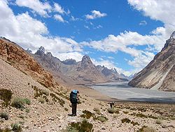
The Shaksgam River (Chinese: 沙克思干河; pinyin: Shakesigan He, Hindi: शक्सगाम नदी, romanized: Shaksgām Nadi, Urdu: دریائے شکسگام, romanized: Daryá-e-Shaksgám) is a left tributary of the Yarkand River. The river is also known as the Kelechin River (Chinese: 克勒青河) and Muztagh River (Chinese: 穆斯塔格河).[1] It rises in the Gasherbrum, Urdok, Staghar, Singhi and Kyagar Glaciers in the Karakoram.[2] It then flows in a general northwestern direction parallel to the Karakoram ridge line in the Shaksgam Valley. It receives the waters of the Shimshal Braldu river and the Oprang river from the Pakistan-administered Hunza District before turning east and joining the Yarkand River. The stretch of the river's course between Shimshal Braldu and Oprang is used as the Pakistan–China border.[3]
| Shaksgam River | |
|---|---|
 | |
 The junction of the Shaksgam River with the Yarkand River | |
| Location | |
| Country | China (disputed by India) |
| Province | Xinjiang |
| Physical characteristics | |
| Source | Karakoram range |
| • location | Gasherbrum Glaciers |
| • coordinates | 35.6084°N 77.33°E |
| Mouth | Yarkand River |
• coordinates | 36.626697°N 76.202991°E |
| Basin features | |
| Progression | Yarkand→ Tarim→ Taitema Lake |
| Tributaries | |
| • left | Shimshal Braldu river, Oprang river |
Administratively, the Chinese part of the valley is within the southernmost portions of Yarkand County (the source) and the Tashkurgan Tajik Autonomous County (lower course). India claims the entire valley as part of its Jammu and Kashmir state, now part of Ladakh.[4]
History
The river valley was explored in 1889 by Francis Younghusband (who referred to the Shaksgam as the Oprang).,[5] and again in 1926 by Kenneth Mason, who confirmed the sources of the river.[6]
Geography
The upper river valley is used by climbers approaching the north face of K2. The approach requires a crossing of the river, which is hazardous. Between its confluence with the Shimshal Braldu River and its confluence with the Oprang River the river forms the border between China and Pakistan administered Kashmir.[1] The area is used as winter pastures by yak herdsmen from the village of Shimshal.[7] Historically, the bed of the Yarkand river where Shaksgam joins it, was used for cultivation by farmers from the state of Hunza. The rulers of Hunza are said to have obtained these "territorial rights to Shaksgam" in the distant past.[8][9]
The average annual temperature in the region can fall below freezing.
See also
- Trans-Karakoram Tract
- Dafdar
- Yinsugaiti Glacier
- Sarpo Laggo Glacier
References
- US Bureau of Intelligence and Research International Boundary Study No. 85 (1968) Archived 2012-02-11 at the Wayback Machine
- Hewitt, K. (1982) Natural dams and outburst floods of the Karakoram Himalaya Archived 2011-07-21 at the Wayback Machine
- Shaksgam river basin, OpenStreetMap, retrieved 13 September 2019.
- Boundary of the Trans-Kakarakoram Tract, OpenStreetMap, retrieved 13 September 2019.
- Younghusband, Francis (1896). The Heart of a Continent. pp. 200ff. ISBN 9788120608504.
- Mason, Kenneth (1928). Exploration of the Shaksgam Valley and Aghil ranges, 1926. pp. 62ff. ISBN 9788120617940.
- 2000 Mock & O'Neil Oprang Expedition Report
- Dani, Ahmad Hasan (1998), "The Western Himalayan States", in M. S. Asimov; C. E. Bosworth (eds.), History of Civilizations of Central Asia, Vol. IV, Part 1 — The age of achievement: A.D. 750 to the end of the fifteenth century — The historical, social and economic setting, UNESCO, pp. 215–225, ISBN 978-92-3-103467-1
- Mehra, Parshotam (1992), An "agreed" frontier: Ladakh and India's northernmost borders, 1846-1947, Oxford University Press, pp. 95–97, ISBN 978-0-19-562758-9
External links
- The Shaksgam river marked on the OpenStreetMap, Upper course: 1, 2, 3, 4, 5, 6, 7; Lower course: 1, 2 3, 4, 5
На других языках
[de] Shaksgam
Der Shaksgam (chinesisch .mw-parser-output .Hani{font-size:110%}沙克斯干河, Pinyin Shakesigan He) ist ein linker Nebenfluss des Yarkant.- [en] Shaksgam River
[es] Río Shaksgam
El río Shaksgam (en chino, 沙克斯干河; pinyin, Shakesigan He), también conocido como río Kelechin o Muztagh,[1] es un río asiático, un afluente por la izquierda del río Yarkand que se encuentra en el valle Shaksgam, en el Baltistan, una parte del territorio en disputa de Cachemira reivindicado por la China. El río discurre siempre por China aunque durante un tramo forma parte de la frontera con Pakistán.[ru] Кырчинбулак
Кырчинбулак[1] (в верховье Шаксгам[2], в низовье Чонтокай[3]) — река на спорной территории между КНР, Пакистаном и Индией. Левый приток Яркенда. По договору между Китаем и Пакистаном — в основном в Синьцзян-Уйгурском автономном районе; небольшой участок является государственной границей.Другой контент может иметь иную лицензию. Перед использованием материалов сайта WikiSort.org внимательно изучите правила лицензирования конкретных элементов наполнения сайта.
WikiSort.org - проект по пересортировке и дополнению контента Википедии