geo.wikisort.org - River
The Kabul River (Urdu: دریائے کابل, Pashto: د کابل سیند, Dari: دریای کابل), the classical Cophen /ˈkoʊfeɪn/, is a 700-kilometre-long (430 mi) river that emerges in the Sanglakh Range of the Hindu Kush mountains in the northeastern part of Maidan Wardak Province, Afghanistan. It is separated from the watershed of the Helmand River by the Unai Pass. The Kabul River empties into the Indus River near Attock, Pakistan. It is the main river in eastern Afghanistan and the Khyber Pakhtunkhwa province of Pakistan.
| Kabul River | |
|---|---|
 Aerial photo of Kabul River flood-plain east of Kabul, Afghanistan | |
 | |
 Mouth of the Kabul River in Pakistan | |
| Location | |
| Countries | Afghanistan and Pakistan |
| Cities | Kabul, Surobi, Jalalabad (Afghanistan); Peshawar, Charsadda, Nowshera (Pakistan) |
| Physical characteristics | |
| Source | Hindu Kush Mountains |
| • location | Maidan Wardak Province, Afghanistan and kuramber lake boroghil plateau Chitral khyberpakhtunkhaw pakistan[where it is locally known as chitral river dariya e Chitral (urdu)] |
| • coordinates | 34.357°N 68.8392°E |
| • elevation | 2,400 m (7,900 ft) |
| Mouth | Indus River |
• location | Attock, Punjab, Pakistan |
• coordinates | 33°55′0″N 72°13′56″E |
| Length | 700 km (430 mi) |
| Basin size | 70,500 km2 (27,200 sq mi) |
| Basin features | |
| Tributaries | |
| • left | Panjshir River, Alingar River, Kunar River, Swat River |
| • right | Logar River, Surkhab River, Bara River |
Course
The Kabul River, which measures 700 kilometres long, passes through the cities of Kabul and Jalalabad in Afghanistan and forms a large drainage of the eastern provinces of Nangarhār, Kunar, Laḡmān, Lōgar, Kabul, Kāpisā, Parvān, Panjšēr, and Bāmiān before it flows into Khyber Pakhtunkhwa in Pakistan some 25 kilometres (16 mi) north of the Durand Line border crossing at Torkham.[1] In Khyber Pakhtunkhwa, the river passes through the cities of Peshawar, Charsadda, and Nowshera. In its upper reaches it is known as the Sarchashma. The major tributaries of the Kabul River are the Logar, Panjshir, Alingar, Surkhab, Kunar, Bara, and Swat rivers.[2]

Hydrology
The Kabul River is little more than a trickle for most of the year, but swells in summer due to melting snows in the Hindu Kush Range. Its largest tributary is the Kunar River, which starts out as the Mastuj River, flowing from the Chiantar glacie in Brughil valley in Chitral, Pakistan and after flowing south into Afghanistan it is met by the Bashgal river flowing from Nurestan. The Kunar meets the Kabul near Jalalabad. In spite of the Kunar carrying more water than the Kabul, the river continues as the Kabul River after this confluence, mainly for the political and historical significance of the name.
Dams
The Kabul River is impounded by several dams that were constructed in the 20th century. Three dams are located in the Kabul and Nangarhar provinces of Afghanistan, including the Surobi dam, a hydroelectric source for Kabul constructed 1957 with assistance by Germany, the Naghlu dam, which was later built by Soviet scientists in the 1960s, and the Darunta dam. The Warsak Dam is also in the Valley of Peshawar in Pakistan, approximately 20 km northwest of the city of Peshawar.[1]
History
Expedition of Alexander the Great into Asia
In Arrian's The Campaigns of Alexander, the River Kabul is referred to as Κωφήν Kōphēn (Latin spelling Cophen).[3][4][5][6]
Modern era
Since the 1990s, the river has experienced substantial droughts in summer.[1] In approximately March 2019, ten of thousands of gallons of untreated sewage from the Makroyan Waste Water Treatment Plant has been dumped into the Kabul River each month, reportedly causing gastrointestinal issues among the 3,000 families that live along the river.[7]
Etymology
In Sanskrit and Avestan
The word Kubhā which is the ancient name of the river is both a Sanskrit and Avestan word. The word later changed to Kābul.[8][9]
Al-Biruni
Al-Biruni also called it "the River of Ghorwand".[10]
The Kabul River later gave its name to the region and to the settlement of Kabul.[10]
Institution Leadership
Kabul River Basin (KRB) is a government authority under the Ministry of Energy and Water (MEW) of the Government of the Islamic Republic of Afghanistan (GoIRA). Based on the Water Law it was created. The recent Director General of this major water institution was Jalal Naser Faqiryar, who brought positive changes, contributed a lot to the transparency, basin development, and applicable policies, especially river basin management which had positive impacts and results.
Gallery
 The Kabul River in the city of Kabul, 1966
 The Kabul River in the city of Kabul, 1982
 The Kabul River in the city of Kabul in 2009, now dried up
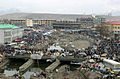 The dried river in the central city of Kabul
 Kabul River valley
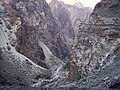 Gorge of the Kabul River, parallel to the Kabul-Jalalabad Road
 Kabul River in Behsood Bridge Area, Jalalabad, 2009
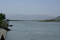 Kabul River in Behsood Bridge Area, Jalalabad, 2009
 Buddhist caves, which have been carved into a set of cliffs on the north side of the Kabul river
 A dam on the river
 Kabul River at Behsood Bridge , Jalalabad


See also
References
- Wilde, A (April 19, 2012). "Kabul River".
- "One Land, Two Rules (9): Delivering public services in insurgency-affected Jalrez district of Wardak province". Afghan Analysts Network. 16 December 2019. Retrieved 30 April 2020.
- Arrian, John Rooke; Arrian (1813). "A brief account of all the authors who have touched upon the history of Alexander". Arrian's History of the expedition of Alexander the Great: and conquest of Persia. Translated by Rooke, John (2nd ed.). J. Davis.
- Cawthorne, Nigel (2004). Alexander the Great. Haus Publishing. ISBN 1-904341-56-X.
- Heckel, Waldemar (2003). The wars of Alexander the Great, 336-323 B.C. Taylor & Francis. ISBN 0-415-96855-0.
- Arrian (2005). Romm, James S. (ed.). Alexander the Great: selections from Arrian, Diodorus, Plutarch, and Quintus Curtius. Translated by Mensch, Pamela. Hackett Publishing. ISBN 0-87220-727-7.
- Lawrence, J.P.; Babakarkhail, Zubair (September 12, 2020). "Sewage from US Embassy, NATO headquarters dumped into Kabul River due to aging infrastructure". Stars and Stripes. Archived from the original on September 15, 2020. Retrieved September 15, 2020.
- Ramesh Chandra Majumdar, Achut Dattatrya Pusalker, A. K. Majumdar, Dilip Kumar Ghose, Bharatiya Vidya Bhavan, Vishvanath Govind Dighe Published by Bharatiya Vidya Bhavan (1962). The History and Culture of the Indian People : The Vedic age. p. 247.
The Kubha is the modern Kabul river which flows into the Indus a little above Attock and receives at Prang the joint flow of its tributaries the Swat (Swastu) and Gauri
{{cite book}}: CS1 maint: multiple names: authors list (link) - Muir, John. Original Sanskrit Texts on the Origin and History of the People of India. p. 352.
'In the older parts of the Rigved the Indian people appear to be settled on the north western border of India, in the Punjab and even beyond the Punjab on the borders of the Kubha river the Kowpher in Kabul. The gradual diffusion of these people from this point towards the east, beyond the Saraswati and Hindustan as far as the Ganges, can be traced almost step by step in the later portions of the Vedic writings
- Bosworth, C.E. (1999). "Kabul". Encyclopaedia of Islam (CD-ROM Edition v. 1.0 ed.). Leiden, The Netherlands: Koninklijke Brill NV.
External links
- Kabul River. Encyclopaedia Iranica.
Authority control | |
|---|---|
| General |
|
| National libraries | |
На других языках
[de] Kabul (Fluss)
Der Kabul (altind. Kubhā, altgriechisch Κωφήν .mw-parser-output .Latn{font-family:"Akzidenz Grotesk","Arial","Avant Garde Gothic","Calibri","Futura","Geneva","Gill Sans","Helvetica","Lucida Grande","Lucida Sans Unicode","Lucida Grande","Stone Sans","Tahoma","Trebuchet","Univers","Verdana"}Kōphēn, arabisch نهر كابل Nahr Kabul ‚Kabul-Fluss‘; paschtunisch .mw-parser-output .Arab a,.mw-parser-output a bdi.Arab{text-decoration:none!important}.mw-parser-output .Arab{font-size:120%}کابل سيند Kabul Sindh) ist ein rechter (westlicher) Nebenfluss des Indus von etwa 460 Kilometern Länge.- [en] Kabul River
[es] Río Kabul
El río Kabul o Kabal (en persa: دریای کابل; en pashto: کابل سیند) es un río que se nace en la sierra de Sanglakh en Afganistán, separado de la línea divisoria de aguas de la cuenca del río Helmand por el paso de Unai. En la antigüedad era conocido como río Cofete.[1][2][it] Kabul (fiume)
Il Kabul (sanscrito: Kubhā ; greco: Κωφήν / Kophén; arabo نهر كابول Nahr Kabul) è un fiume dell'Asia che nasce dalle propaggini delle montagne dell'Indo Kush e che dopo aver attraversato la valle che porta lo stesso nome e bagnato le città di Kabul e Jalalabad passa nel territorio del Pakistan nei pressi del passo di Khyber dove confluisce nell'Indo nei pressi della città di Nowshera.[ru] Кабул (река)
Кабу́л[1][2][3][4] (пушту и дари کابل — Кабуль[5]; др.-инд. Kubhā) — трансграничная река, протекающая в восточной части Афганистана и в северо-западной части Пакистана. Правый и самый крупный приток реки Инд[1], впадающий в него у города Атток[3]. В верховье носит названия Майданруд, Лаландар[6]. Крупнейшие притоки Кунар, Панджшер и Логар[3]. Протекает через Кабул, Джелалабад и Пешавар[3].Другой контент может иметь иную лицензию. Перед использованием материалов сайта WikiSort.org внимательно изучите правила лицензирования конкретных элементов наполнения сайта.
WikiSort.org - проект по пересортировке и дополнению контента Википедии