geo.wikisort.org - Reservoir
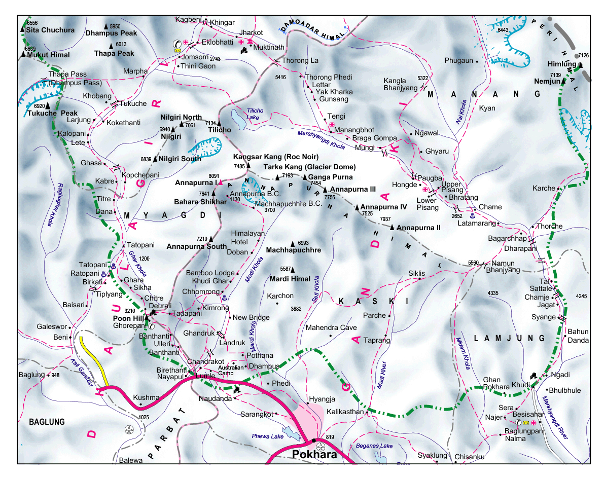
Tilicho Lake (pronounced [tilit͡so]) is a lake located in the Manang district of Nepal, 55 kilometres (34 mi) as the crow flies from the city of Pokhara. It is situated at an elevation of 4,919 metres (16,138 ft) in the Annapurna range of the Himalayas. Another source lists the elevation of Lake Tilicho as being 4,949 metres (16,237 ft).[1][2] According to the Nepali Department of Hydrology & Meteorology (2003), no aquatic organism has been recorded in the lake.[citation needed]
| Tilicho lake | |
|---|---|
 | |
 Tilicho lake Location in Nepal | |
| Location | Annapurna, Manang, Nepal |
| Coordinates | 28°41′30″N 83°51′10″E |
| Type | Glacial lake |
| Basin countries | Nepal |
| Max. length | 4 km (2.5 mi) |
| Max. width | 1.2 km (0.75 mi) |
| Surface area | 4.8 km2 (1.9 sq mi) |
| Average depth | 85 m (279 ft) |
| Water volume | 156×106 L (41,000,000 US gal) (Fresh Water) |
| Surface elevation | 4,919 m (16,138 ft) |
 | |
Tilicho Lake is the destination of one of the most popular side hikes of the Annapurna Circuit trek. The hike takes additional 3–4 days. No camping is required, as new lodges have been built between Manang and the lake. The final approach to the lake is done in a day hike from the lodge at Tilicho Base Camp.
Trekkers attempting the Annapurna Circuit route usually cross the watershed between Manang and Kali Gandaki valleys over the 5416 meters high Thorong La pass. The alternate route, skirting Tilicho Lake from the north, has been gaining popularity. This route is more demanding and requires at least one night of camping. There are no teahouses or lodges past the Tilicho Base Camp lodge some kilometers east of the lake and the next village of Thini Gaon in the Kali Gandaki valley. Most groups spend two nights between these places. There are two passes leading to Thini Gaon and Jomsom; Mesokanto La and Tilicho North pass known also as Tilicho "Tourist pass". These routes via Tilicho Lake are more often closed by snow than the higher Thorong La.[citation needed]
Tilicho Lake was the site of one of the highest ever altitude scuba dives. A Russian diving team, consisting of Andrei Andryushin, Denis Bakin, and Maxim Gresko, conducted a scuba dive in the lake in 2000.[3]
Religious Significance
Hindus believe that Tilicho Lake is the ancient Kak Bhusundi Lake mentioned in the epic Ramayana.[4] The sage Kak Bhusundi is believed to have first told the happenings of Ramayana to Garuda - king of birds, near this lake. The sage took the form of a crow while telling the story to Garuda. Crow translates to Kak in Sanskrit, hence the name Kak Bhusndi for the sage.
Surrounding mountains
The mountains surrounding the lake are Khangsar, Muktinath peak, Nilgiri, and Tilicho.[5]
See also
- Gurudongmar Lake
- Lake Tsongmo
- Licancabur
References
- "The Highest Lake in the World". highestlake.com. Retrieved 2006-12-07.
- "Lake Tilicho is World's highest elevation lake situated at an elevation of 4,949m from sea level - Picture of Nepal, Asia - Tripadvisor".
- "The Highest Lake in the World". www.highestlake.com. Retrieved 2010-03-25.
- "Annapurna Circuit Trek with Tilicho Lake | Classic Annapurna Circuit Trek- Ambition". Ambition Himalaya Treks & Expeditions Pvt. Ltd. Retrieved 2018-07-17.
- "Surrounding mountains of Tilicho Lake".
External links
- "Tilicho Lake". panhala.net. Photo.
- "Tilicho Lake and Peak 2007". fordon-himalaje2007.
- "Tilicho Lake Trek". adventureboundnepal.com.
- "Tilicho Lake Trek". dreamhimlyan.com.
- "Tilicho Lake trekking map". treknepalhimalya.com.
- "Tilicho Base Camp Trek/ tilicho lake trek". alfrescoadventure.com.
Hydrography of Nepal | ||||||||||||
|---|---|---|---|---|---|---|---|---|---|---|---|---|
| Rivers |
| |||||||||||
| Lakes |
| |||||||||||
| Glaciers |
| |||||||||||
| Icefalls |
| |||||||||||
| Dams, barrages | ||||||||||||
| Related topics |
| |||||||||||
| Hydrography of surrounding areas |
| |||||||||||
Authority control | |
|---|---|
| General |
|
| National libraries | |
| Other |
|
На других языках
[de] Tilichosee
Der Tilichosee (Aussprache: Tilitscho) liegt auf einer Höhe von 4919 m in der Annapurna-Region in Zentral-Nepal.- [en] Tilicho Lake
[fr] Lac Tilicho
Le lac Tilicho est un des lacs les plus hauts du monde[1]. Il se situe à 4 919 m d'altitude dans la région des Annapurna dans le massif de l'Himalaya au Népal. Il a été découvert par l'expédition d'alpinisme française de 1950 à l'Annapurna, qui effectuait alors une reconnaissance pour trouver les voies d'accès vers le sommet. Les cartes de la région, encore très sommaires, ont ensuite été redessinées et fait apparaître le lac.[ru] Тиличо (озеро)
Озеро Тиличо (непальск. तिलिचो) — высокогорное каровое озеро в Непале. Расположено в центральных Гималаях на высоте 4919 м над уровнем моря у северного склона пика Тиличо (7134 м)[2].Другой контент может иметь иную лицензию. Перед использованием материалов сайта WikiSort.org внимательно изучите правила лицензирования конкретных элементов наполнения сайта.
WikiSort.org - проект по пересортировке и дополнению контента Википедии