geo.wikisort.org - Mountains
Huangshan (Chinese: 黄山),[2] literally meaning the Yellow Mountain(s), is a mountain range in southern Anhui Province in eastern China. It was originally called “Yishan”, and it was renamed because of a legend that Emperor Xuanyuan once made alchemy here.[3] Vegetation on the range is thickest below 1,100 meters (3,600 ft), with trees growing up to the treeline at 1,800 meters (5,900 ft).
| Huangshan 黄山 | |
|---|---|
 Panoramic view of the Huangshan landscape | |
| Highest point | |
| Elevation | 1,864 m (6,115 ft)[1] |
| Prominence | 1,734 m (5,689 ft)[1] |
| Listing | Ultra |
| Coordinates | 30°07′30″N 118°10′00″E[1] |
| Geography | |
 Huangshan 黄山 Location in eastern China  Huangshan 黄山 Huangshan 黄山 (China) | |
| Location | Huangshan City, Anhui |
UNESCO World Heritage Site | |
| Official name | Mount Huangshan |
| Criteria | Cultural and Natural: (ii), (vii), (x) |
| Reference | 547bis |
| Inscription | 1990 (14th Session) |
| Extensions | 2012 |
| Area | 16,060 ha (62.0 sq mi) |
| Buffer zone | 49,000 ha (190 sq mi) |
| Huangshan | |||||||||||||||||||||||||
|---|---|---|---|---|---|---|---|---|---|---|---|---|---|---|---|---|---|---|---|---|---|---|---|---|---|
 "Huangshan" in Simplified (top) and Traditional (bottom) Chinese characters | |||||||||||||||||||||||||
| Simplified Chinese | 黄山 | ||||||||||||||||||||||||
| Traditional Chinese | 黄山 | ||||||||||||||||||||||||
| Literal meaning | "Yellow Mountain(s)" | ||||||||||||||||||||||||
| |||||||||||||||||||||||||
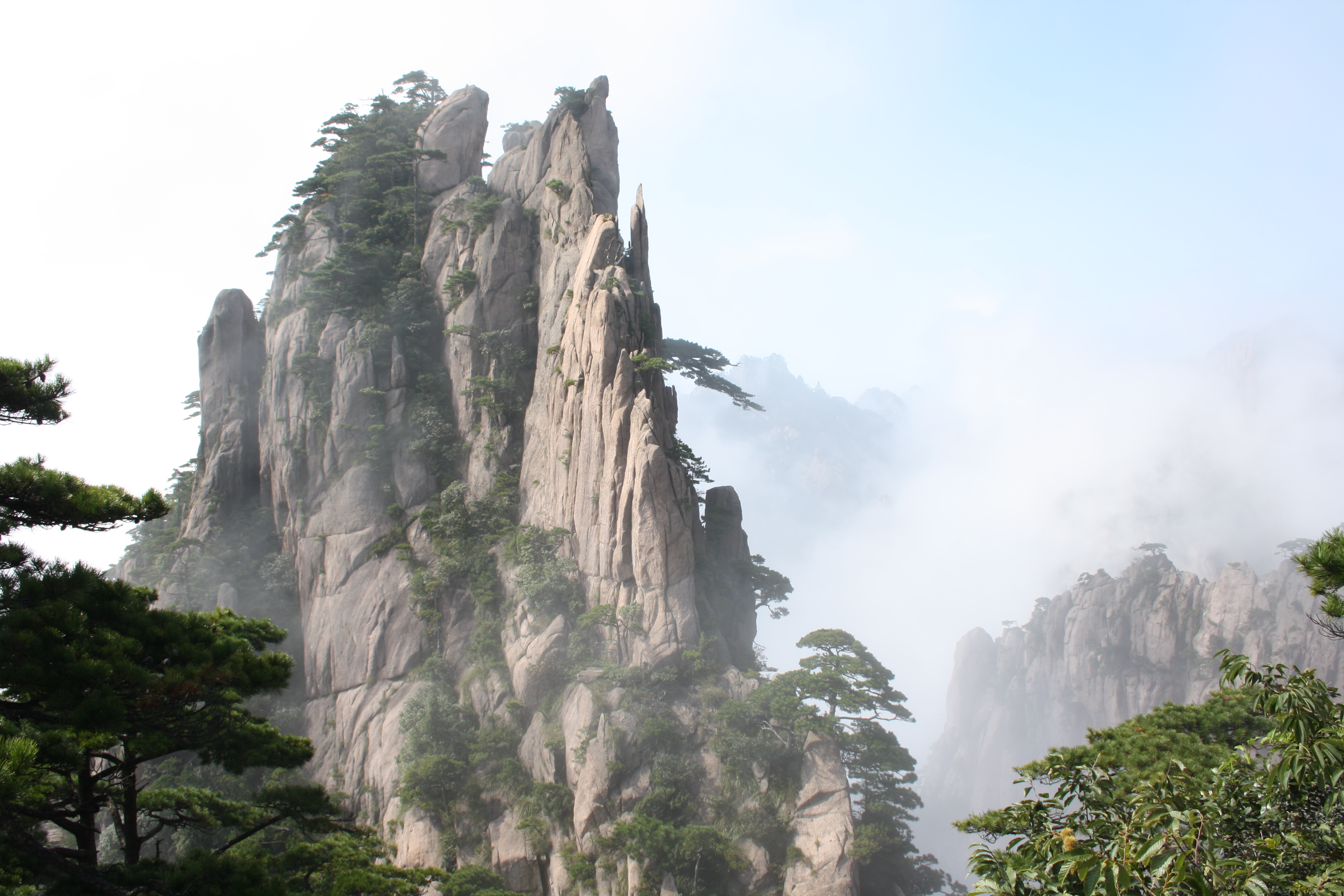
The area is well known for its scenery, sunsets, peculiarly-shaped granite peaks, Huangshan pine trees, hot springs, winter snow and views of the clouds from above. Huangshan is a frequent subject of traditional Chinese paintings and literature, as well as modern photography. It is a UNESCO World Heritage Site and one of China's major tourist destinations.
Physical description


The Huangshan mountain range has many peaks, some more than 1,000 meters (3,250 feet) high.[4] The three tallest and best-known peaks are Lotus Peak (Lianhua Feng, 1,864 m), Bright Peak (Guangming Ding, 1,860 m) and Celestial Peak (Tiandu Feng, literally Capital of Heaven Peak, 1,829 m).[2][5] The World Heritage Site covers a core area of 154 square kilometres and a buffer zone of 142 square kilometres.[6] The mountains were formed in the Mesozoic, approximately 100 million years ago, when an ancient sea disappeared due to uplift.[7] Later, in the Quaternary Period, the landscape was shaped by the influence of glaciers.[7]
The vegetation of the area varies with elevation. Mesic forests cover the landscape below 1,100 meters. Deciduous forest stretches from 1,100 meters up to the tree line at 1,800 meters. Above that point, the vegetation consists of alpine grasslands. The area has diverse flora, where one-third of China's bryophyte families and more than half of its fern families are represented. The Huangshan pine (Pinus hwangshanensis) is named after Huangshan and is considered an example of vigor because the trees thrive by growing straight out of the rocks.[7] Many of the pine trees in the area are more than a hundred years old and have been given their own names (such as the Ying Ke Pine, or Welcoming-Guests Pine, which is thought to be more than 1500 years old).[5] The pines vary greatly in shape and size, with the most crooked of the trees being considered the most attractive.[8] Furthermore, Huangshan's moist climate facilitates the growing of tea leaves[9] and the mountain has been called "one of China's premier green tea-growing mountains.[10] Mao feng cha ("Fur Peak Tea"), a well-known local variety of green tea,[11] takes its name from the downy tips of tea leaves found in the Huangshan area.[12]
The mountaintops often offer views of the clouds from above, known as the Sea of Clouds (Chinese: 云海; pinyin: yúnhǎi)[9] or "Huangshan Sea"[8] because of the cloud's resemblance to an ocean, and many vistas are known by names such as "North Sea" or "South Sea."[8] One writer remarked on the view of the clouds from Huangshan as follows:
To enjoy the magnificence of a mountain, you have to look upwards in most cases. To enjoy Mount Huangshan, however, you've got to look downward.[8]
The area also is host to notable light effects, such as the renowned sunrises. Watching the sunrise is considered a "mandatory" part of visiting the area.[13] A phenomenon known as Buddha's Light (Chinese: 佛光; pinyin: fóguāng)[14] is also well-known and, on average, Buddha's Light only appears a couple of times per month.[15] In addition, Huangshan has multiple hot springs, most of them located at the foot of the Purple Cloud Peak. The water stays at 42 °C (107.6 °F) all year,[16] and has a high concentration of carbonates. The waters are said to help prevent skin, joint, and nerve illness.[7]
History


Huangshan was formed approximately 100 million years ago and gained its unique rock formations in the Quaternary Glaciation.[7]
During the Qin dynasty, Huangshan was known as Yishan (Mount Yi). In 747 AD, its name was changed to Huangshan (Mount Huang) by imperial decree;[17] the name is commonly thought to have been coined in honor of Huang Di (the Yellow Emperor), a legendary Chinese emperor and the mythological ancestor of the Han Chinese.[18] One legend states that Huangshan was the location from which the Yellow Emperor ascended to Heaven.[5] Another legend states that the Yellow Emperor "cultivated moral character and refined Pills of Immortality in the mountains, and in so doing gave the mountains his name.[7] The first use of this name "Huangshan" often is attributed to Chinese poet Li Bai.[18] Huangshan was fairly inaccessible and little-known in ancient times, but its change of name in 747 AD seems to have brought the area more attention; from then on, the area was visited frequently and many temples were built there.[17]
Huangshan is known for its stone steps,[5] carved into the side of the mountain, of which there may be more than 60,000 throughout the area.[13][19][20] The date at which work on the steps began is unknown, but they have been said to be more than 1,500 years old.[19]
Over the years, many scenic spots and physical features on the mountain have been named;[8] many of the names have narratives behind them. For example, one legend tells of a man who did not believe the tales of Huangshan's beauty and went to the mountains to see them; almost immediately, he was converted to the same view. One of the peaks he is said to have visited was named Shixin (始信), roughly meaning "start to believe."[8]
In 1982, Huangshan was declared a "site of scenic beauty and historic interest" by the State Council of China.[17] It was named a UNESCO World Heritage Site in 1990 for its scenery and for its role as a habitat for rare and threatened species.[21] Subsequently, certified as a National Geopark, and then as a regional geopark (Asia Pacific Geopark Network), it was admitted as a UNESCO Global Geopark in 2004.
In 2002, Huangshan was named the "sister mountain" of Jungfrau in the Swiss Alps.[5]
Artistic and scientific inspirations

Much of Huangshan's reputation derives from its significance in Chinese arts and literature.[22] In addition to inspiring poets such as Li Bai,[13][6] Huangshan and the scenery therein has been the frequent subject of poetry and artwork, especially Chinese ink painting[17] and, more recently, photography.[2] Overall, from the Tang dynasty to the end of the Qing dynasty, more than 20,000 poems were written about Huangshan, and a school of painting named after it.[5][8] The mountains also have appeared in modern works; director James Cameron cited Huangshan as one of his influences in designing the fictional world of his 2009 film Avatar, and Chinese animated series Stitch & Ai, a spin-off of Disney's Lilo & Stitch franchise, is set in the Huangshan mountains.[citation needed]
The area also has been a location for scientific research because of its diversity of flora and wildlife. In the early part of the twentieth century, the geology and vegetation of Huangshan were the subjects of multiple studies by both Chinese and foreign scientists.[17] The mountain is still a subject of research. For example, in the late twentieth century a team of researchers used the area for a field study of Tibetan macaques, a local species of monkey.[23]
Tourism

Having at least 140 sections open to visitors,[21] Huangshan is a major tourist destination in China.[2][13] Huangshan City changed its name from Tunxi (屯溪) in 1987 in order to promote Huangshan tourism.[24] In 2007 more than 1.5 million tourists visited the mountain.[25] The city is linked by rail and by air to Shanghai,[2] and also is accessible from cities such as Hangzhou, Zhejiang and Wuhu, Anhui.[26] Buses connect Huangshan City to the base of the mountain, where visitors can take a cable car or hike to the summit.[2]
There are more than 50 kilometers of footpaths providing access to scenic areas for visitors and staffers of the facilities.[17] Throughout the area there are hotels and guest houses that accommodate overnight visitors,[2][17] many of whom hike up the mountains, spend the night at one of the peaks to view the sunrise, and then descend by a different route the next day.[13] The area is classified as a AAAAA scenic area by the China National Tourism Administration.[27]
The hotels, restaurants, and other facilities at the top of the mountain are serviced and kept stocked by porters who carry resources around the mountain on foot, hanging their cargo from long poles balanced over their shoulders or backs.[28]
Climate
Huangshan has a humid continental climate (Köppen Climate Classification Dfb). Its elevation makes it colder and wetter than the rest of Anhui.
| Climate data for Huangshan (1981–2010 normals) | |||||||||||||
|---|---|---|---|---|---|---|---|---|---|---|---|---|---|
| Month | Jan | Feb | Mar | Apr | May | Jun | Jul | Aug | Sep | Oct | Nov | Dec | Year |
| Record high °C (°F) | 12.9 (55.2) |
13.8 (56.8) |
16.3 (61.3) |
22.3 (72.1) |
24.5 (76.1) |
25.7 (78.3) |
27.6 (81.7) |
27.1 (80.8) |
26.0 (78.8) |
23.7 (74.7) |
17.7 (63.9) |
14.2 (57.6) |
27.6 (81.7) |
| Average high °C (°F) | 1.2 (34.2) |
2.9 (37.2) |
6.6 (43.9) |
11.6 (52.9) |
15.8 (60.4) |
18.1 (64.6) |
20.5 (68.9) |
20.3 (68.5) |
17.0 (62.6) |
12.9 (55.2) |
8.3 (46.9) |
3.4 (38.1) |
11.5 (52.8) |
| Average low °C (°F) | −5.2 (22.6) |
−3.7 (25.3) |
−0.5 (31.1) |
4.9 (40.8) |
9.5 (49.1) |
13.1 (55.6) |
15.9 (60.6) |
15.4 (59.7) |
11.7 (53.1) |
6.9 (44.4) |
1.9 (35.4) |
−3.1 (26.4) |
5.6 (42.0) |
| Record low °C (°F) | −22.0 (−7.6) |
−19.1 (−2.4) |
−15.9 (3.4) |
−11.7 (10.9) |
−4.7 (23.5) |
1.3 (34.3) |
8.5 (47.3) |
6.8 (44.2) |
−0.6 (30.9) |
−9.8 (14.4) |
−19.0 (−2.2) |
−22.7 (−8.9) |
−22.7 (−8.9) |
| Average precipitation mm (inches) | 85.4 (3.36) |
107.8 (4.24) |
175.2 (6.90) |
214.3 (8.44) |
250.9 (9.88) |
384.4 (15.13) |
341.5 (13.44) |
278.3 (10.96) |
153.9 (6.06) |
100.2 (3.94) |
90.7 (3.57) |
53.2 (2.09) |
2,235.8 (88.01) |
| Average precipitation days (≥ 0.1 mm) | 14.0 | 14.7 | 18.4 | 17.6 | 18.0 | 18.1 | 16.3 | 18.2 | 14.5 | 12.1 | 9.7 | 8.9 | 180.5 |
| Source: National Meteorological Center of CMA[29][30][31] | |||||||||||||
Panoramas


Image gallery
 View from a cable car
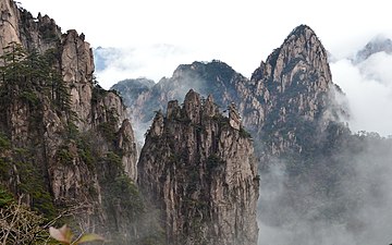 Bijia Peak
 Artificial steps on the cliffs of Huangshan
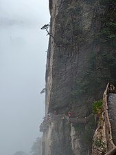 Xihai Great Canyon
 Shixin Peak
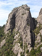 A rock formation in Huangshan
 Carved steps to Tiandu Peak
 A rock formation in Huangshan
 Huangshan pines
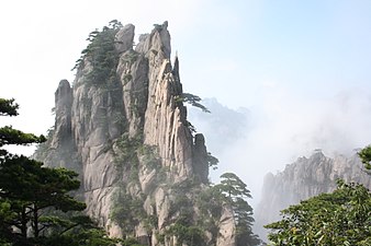 Huangshan with trees and clouds
 Summit of mountain in HuangShan


See also
- List of World Heritage Sites in China
- Sacred Mountains of China
References
- "Lianhua Feng - Lotus Peak, HP Huang Shan" on Peaklist.org - Central and Eastern China, Taiwan and Korea. This data is specific to the high point of the range only. Retrieved 2011-10-5.
- Bernstein, pp. 125–127.
- "Origins and new interpretations on the theory of Pleistocene glaciation in South-East China - the case of the Lushan and Huangshan ranges". Annales de Géographie. 101: 472.
- "Huangshan Mountain". [Huangshan Tour]. Archived from the original on 3 March 2009. Retrieved 2008-08-05.
- Cao, pp. 114–127.
- "Mount Huangshan - UNESCO World Heritage Center". UNESCO. 2008. Retrieved 2008-08-05.
- Huangshan Mountains, p. 12.
- Guo, pp. 62–64.
- Heiss, p. 124
- Heiss, p. 113
- Heiss, p. 52
- "Yellow Mountain Maofeng Tea". [Cultural China]. Archived from the original on 2009-03-02. Retrieved 2008-10-08.
- Butterfield, Fox (1981-02-08). "China's Majestic Huang Shan". New York Times. Retrieved 2008-10-08.
- China News Service (21 December 2007). ""Buddha's Light" in Huangshan Mountain". China.org.cn. Retrieved 23 December 2008.
- Raitisoja, Geni (4 October 2006). "Huangshan: "No. 1 Mountain Under Heaven"". gbtimes.com. Retrieved 30 December 2014.
- "Welcome to Huang Shan, Mount Huang". [Famous Taoism and Buddhism Sanctuaries in China]. Wudang Taoist Internal Alchemy. Archived from the original on 2008-10-21. Retrieved 2008-09-08.
{{cite web}}: External link in|publisher= - "Mount Huangshan Scenic Beauty and Historic Interest Site". [Protected Areas and World Heritage]. United Nations Environment Programme. October 1990. Archived from the original on 2008-05-10. Retrieved 2008-10-08.
- "Huang Shan". [ChinaTravel.net]. Archived from the original on 2008-10-07. Retrieved 2008-10-08.
- "The Mystic World of Shanshui: Huangshan". UNESCO Culture Center. UNESCO. Archived from the original (.wmv) on 2008-08-16. Retrieved 2008-10-08.
{{cite web}}: External link in|work= - McGraw, David (2003). "Magic Precincts" (PDF). University of Hawaii. Archived from the original (PDF) on 18 September 2009. Retrieved 6 December 2008. p. 52.
- "Mount Huangshan". China.org.cn. 1990. Retrieved 2008-10-08.
- McGraw, p. 109
- Ogawa, p.9.
- "Mt.Huangshan Travel Guide" ChinaTour.Net Accessed 2015-1-21
- "China's Huangshan to restrict vehicles during Olympics". Xinhua. 3 August 2008. Archived from the original on 6 November 2012. Retrieved 6 September 2010.
- "Hefei, Anhui Province". Archived from the original on 20 December 2008. Retrieved 23 December 2008.
- "AAAAA Scenic Areas". China National Tourism Administration. 16 November 2008. Archived from the original on 4 April 2014. Retrieved 9 April 2011.
- Heiss, p. 132
- 黄山风景区-天气预报. China Meteorological Administration. Retrieved 2018-08-08.
- 中国气象局
- 气候资源数据库
Bibliography

- Bernstein, Ken (1999). China pocket guide. Revised by JD Brown; edited by Richard Wallis. Berlitz Publishing Company. ISBN 2-8315-7049-2.
- Cao Nanyan (2003). China: World Heritage Sites. Beijing: China Architecture and Building Press. ISBN 0-7607-8685-2.
- Guo Changjian; Song Jianzhi (2003). World Heritage Sites in China. 五洲传播出版社 (Wuzhou Publishing House). ISBN 7-5085-0226-4.
- Heiss, Mary Lou; Robert J. Heiss (2007). The Story of Tea. Ten Speed Press. p. 122. ISBN 978-1-58008-745-2.
Huangshan.
- Huangshan Mountains. China Travel and Tourism Press. 1998. ISBN 7-5032-1520-8.
- Ogawa, Hideshi; Akie Yanagi (2006). Wily Monkeys: Social Intelligence of Tibetan Macaques. Trans Pacific Press. ISBN 1-920901-97-3.
External links
- Huangshan overview by the Huangshan Management Committee
- Huangshan Mountain Travel Guide by Huangshan China International Travel Service
- Huizhou Geography Essay by Huizhou Geography
World Heritage Sites in China | ||
|---|---|---|
| East |
|  |
| South Central |
| |
| Southwest |
| |
| North |
| |
| Northeast |
| |
| Northwest |
| |
| Multiple regions |
| |
Mountain ranges of China | |
|---|---|
Geography of China | |
| Northwest China | |
| Qinghai-Tibet and Southwest China | |
| Northeast China | |
| North and East China | |
| Central China | |
| South China | |
| Authority control: National libraries |
|---|
На других языках
[de] Huang Shan
Huang Shan (chinesisch .mw-parser-output .Hant{font-size:110%}黃山 / 黄山, Pinyin Huáng Shān – „Gelbe Berge“) ist ein Gebirge im Verwaltungsgebiet der bezirksfreien Stadt Huangshan in der Provinz Anhui im Süden der Volksrepublik China.- [en] Huangshan
[es] Montes Huang
Las montes Huang o Huangshan (literalmente, montañas amarillas) son una cadena de montañas situadas al sur de la provincia china de Anhui. Desde el año 1990 está considerada como Patrimonio de la Humanidad por la Unesco. La zona es conocida por la belleza de sus picos de granito, por sus bosques de coníferas y por la vista que ofrecen las nubes en lo alto. Las montañas han servido de modelo a numerosos pintores.[fr] Monts Huang
Les monts Huang, ou Huangshan ou monts Jaunes (chinois : 黄山 ; pinyin : huángshān ; litt. « montagnes jaunes ») sont un massif montagneux de l'Anhui méridional, province de l'est de la Chine. La région est connue pour sa beauté, qui repose sur la forme des pics de granite, sur celle tourmentée des conifères, et sur les nuages qui entourent fréquemment le massif. Cette montagne mythique change sans cesse de visage au gré des vents et des bruines... désespérant parfois les artistes qui désirent en fixer la beauté. La région abrite également des sources d'eau chaude, et des sources minérales qui alimentent des piscines naturelles. Ces montagnes sont un sujet privilégié pour la peinture et la littérature chinoises traditionnelles. Elles constituent désormais une destination touristique prisée. Les monts Huang reçoivent plus d'un million de visiteurs par an. Un téléphérique moderne permet de se hisser jusqu'à 1 800 mètres d'altitude, mais les marcheurs courageux peuvent choisir l'ascension des 4 000 marches qui mènent au sommet du pic du Lotus. Là, le regard embrasse une forêt d'aiguilles granitiques, noyées de brume et piquetées de pins aux formes tourmentées.[it] Huangshan
I Monti Huangshan (in cinese:黄山, Huáng Shān, che letteralmente significa "Montagna Gialla") sono una catena montuosa che si trova nella provincia dell'Anhui, nella Cina orientale. L'area è famosa per le sue bellezze paesaggistiche: vi si trovano infatti picchi granitici, i pini dello Huangshan (alberi tipici della regione dalle forme modellate dalle intemperie) e vi si possono inoltre ammirare le formazioni nuvolose dall'alto. Questi monti sono spesso stati usati come sfondo per dipinti e storie della letteratura cinese. Nel 1990 sono stati inseriti nell'elenco dei Patrimoni dell'umanità dell'UNESCO.[ru] Хуаншань
Хуаншань (кит. упр. 黄山, пиньинь Huángshān, буквально: «Жёлтые горы») — горная гряда в провинции Аньхой в восточной части Китая (примерно 300 километров на юго-запад от Шанхая). Этот район известен своими гранитными скалами, покрытыми соснами, воспетыми китайскими художниками и поэтами со времён династии Цинь. Современное название (Жёлтые горы) им было дано поэтом Ли Бо в 747 году. Высота 77 вершин в этой гряде превышает 1000 м. Три самых высоких пика: Пик Лотоса (Ляньхуафэн, 1,864 м), Пик Света (Гуаньминдин, 1,840 м) и Пик Небесной Столицы (Тяньдуфэн, 1,829 м). С 1990 года район Хуаншань входит в список Всемирного наследия ЮНЕСКО и является национальным парком КНР, одним из самых популярных туристических мест Китая.Другой контент может иметь иную лицензию. Перед использованием материалов сайта WikiSort.org внимательно изучите правила лицензирования конкретных элементов наполнения сайта.
WikiSort.org - проект по пересортировке и дополнению контента Википедии