geo.wikisort.org - Mountains
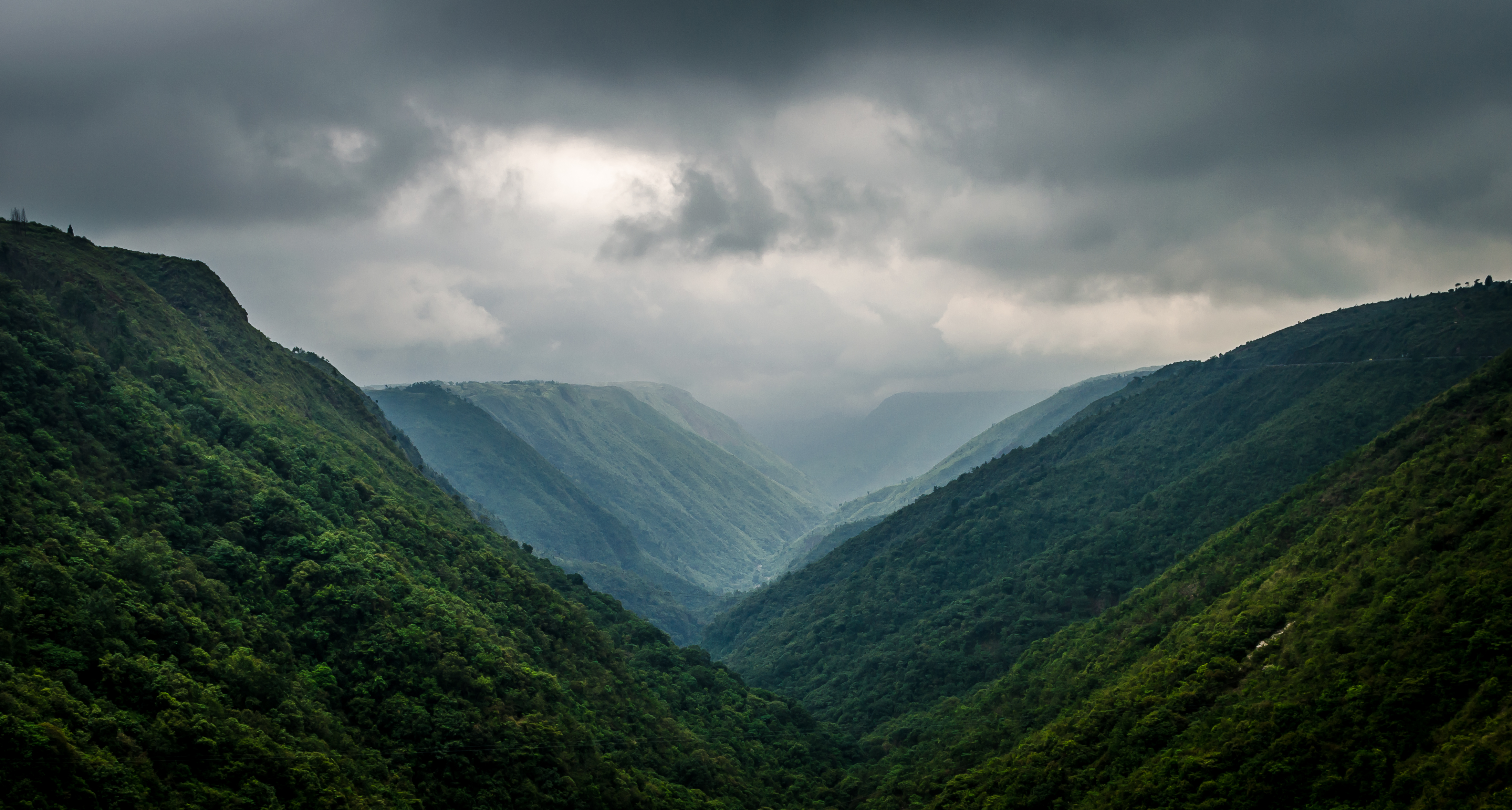
The Khasi Hills (/ˈkɑːsi/) is a low mountain formation on the Shillong Plateau in Meghalaya state of India. The Khasi Hills are part of the Garo-Khasi-Jaintia range and connects with the Purvanchal Range and larger Patkai Range further east. Khasi Hills, and the whole Garo-Khasi-Jaintia range, are in the Meghalaya subtropical forests ecoregion.
Khasi Hills | |
|---|---|
Region | |
 Eastern Khasi Hills | |
| Country | |
| State | Meghalaya |
| Area | |
| • Total | 10,443 km2 (4,032 sq mi) |
| Population (2011) | |
| • Total | 1,468,223 |
| • Density | 140/km2 (360/sq mi) |
| Languages | |
| • Spoken | |
| Districts |
|
Khasi Hills, and the entire Meghalaya state was administratively part of Assam before 1970. In older sources in particular, the alternative transcription Khasia Hills is seen.[1]
The region is inhabited mainly by tribal Khasi dwellers, which are traditionally in various chieftainships, states known as the Khasi Hill States. One of its capitals, Sohra, is considered one of the wettest places in the world.[2] The majority of Khasis are Presbyterians followed by Catholics and Anglicans.
The region came under the Khasi Hills district, which was divided into West Khasi Hills and East Khasi Hills districts on 28 October 1976.[3]
The highest peak is Lum Shyllong which is 1,968 metres (6,457 ft) high.[4] It is situated a few kilometers south of Shillong town.[5]
Administration
Administratively, the Khasi Hills used to be a part of the Khasil Hills district.[6] The district was divided into East Khasi Hills district[7] and West Khasi Hills district on 28 October 1976. On 4 June 1992, the Ri-Bhoi District was carved out of the East Khasi Hills District.[citation needed]
Demographics
The population of the region according to the 2011 Census is 1,468,223.
Religion
Religion in Khasi Hills (2011)[8]
A vast majority of 1,128,769 people in Khasi Hills follow Christianity of various denominations mostly Presbyterian and Catholic. Hinduism is mainly followed by 182,353 people mainly Non-Tribals (Bengalis, Nepalis, Biharis, Marwaris etc) living in the region. A small segments of khasi tribe numbering around 127,735 still follow their own indigenous tribal Religion called "Ka Niamtre", Islam is a micro-scopic minority with around 17,471 people following it.[8] While 0.81 percent follow other religions.
Language
Khasi is spoken by 1,149,178 people as their mother tongue, Garo is spoken by 88,533. While Bengali and Nepali came under 3th and 4th position and is spoken by 56,086 and 48,010 people.[10] A vast number Non tribals can only be found in multi-diverse East Khasi Hills district.
See also
- Garo Hills
- Khasi and Jaintia Hills
- Patkai
References
- Sarkar, A.B. Chaudhuri & D.D. (2003). Megadiversity conservation : flora, fauna, and medicinal plants of India's hot spots. Delhi: Daya Publishing House. ISBN 8170353017.
- Bhaumik, Subir (28 April 2003). "World's wettest area dries up" (stm). South Asia News. Calcutta: BBC. Retrieved 21 February 2008.
- Bhattacharjya, Umasaday (1980). Local government in Khasi Hills. Vivek, 1980. p. 263.
- Karlsson, Bengt G. (2010). Unruly hills : a political ecology of India's northeast. New York: Berghahn Books. ISBN 978-0857451040.
- Riggins, Stephen Harold, ed. (1990). Beyond Goffman : studies on communication, institution, and social interaction. Berlin [u.a.]: Mouton de Gruyter. ISBN 3110122081.
- Shangpliang, Rekha M. (2010). Forest in the life of the Khasis. New Delhi: Concept Pub. Co. ISBN 978-8180696671.
- "East Khasi hills". Government of India. Retrieved 15 August 2012.
- "Population by religion community – 2011". Census of India, 2011. The Registrar General & Census Commissioner, India. Archived from the original on 25 August 2015.
- ORGI. "C-16: Population by Mother Tongue". www.censusindia.gov.in. Office of the Registrar General & Census Commissioner, India. Archived from the original on 15 August 2018. Retrieved 10 July 2018.
- DDW-C16-STMT-MDDS-0000.xlsx
Further reading
- Yule, Henry (1844). "Notes on the Khasia Hills, and people". Journal of the Asiatic Society of Bengal. 14 Part 2, Jul–Dec (152): 612–631.
| |||||||||||||||||||||
| |||||||||||||||||||||
| |||||||||||||||||||||
| |||||||||||||||||||||
| |||||||||||||||||||||
|
Geography of Asia | |
|---|---|
| Sovereign states |
|
| States with limited recognition |
|
| Dependencies and other territories |
|
| |
Climate of Asia | |
|---|---|
| Sovereign states |
|
| States with limited recognition |
|
| Dependencies and other territories |
|
| |
Authority control | |
|---|---|
| General |
|
| National libraries | |
На других языках
- [en] Khasi Hills
[es] Montañas Khasi
Las montañas Khasi ( Khasi Hills ) son un grupo montañoso del noreste de la India, en Meghalaya, parte de la cordillera Garo-Khasi, y de la cordillera de Patkai en la ecorregión de los bosques subtropicales de Meghalaya.[1][fr] Khasi (montagne)
Les Khasi Hills sont des montagnes de l'État de Meghalaya en Inde. Elles font partie de la chaîne Garo-Khasi-Jaintia dans le massif Patkai.[it] Monti Khasi
I Monti Khasi (in inglese Khasi Hills) sono un gruppo montuoso del nordest dell'India, nello stato del Meghalaya, parte della catena Garo-Khasi e della catena di Patkai nell'ecoregione delle foreste subtropicali del Meghalaya.[1]Другой контент может иметь иную лицензию. Перед использованием материалов сайта WikiSort.org внимательно изучите правила лицензирования конкретных элементов наполнения сайта.
WikiSort.org - проект по пересортировке и дополнению контента Википедии