geo.wikisort.org - River
The Lena (Russian: Ле́на, IPA: [ˈlʲɛnə]; Evenki: Елюенэ, Eljune; Yakut: Өлүөнэ, Ölüöne; Buryat: Зүлхэ, Zülkhe; Mongolian: Зүлгэ, Zülge) is the easternmost of the three great Siberian rivers that flow into the Arctic Ocean (the other two being the Ob and the Yenisey). Permafrost underlies most of the catchment, 77% of which is continuous. It is 4,294 km (2,668 mi) long, and has a drainage basin of 2,490,000 km2 (960,000 sq mi).[6] The Lena is the eleventh-longest river in the world, and the longest river entirely within Russia.
This article may require cleanup to meet Wikipedia's quality standards. The specific problem is: formatting, layout, poor grammar and syntax, use of non-English words. (August 2013) |
| Lena | |
|---|---|
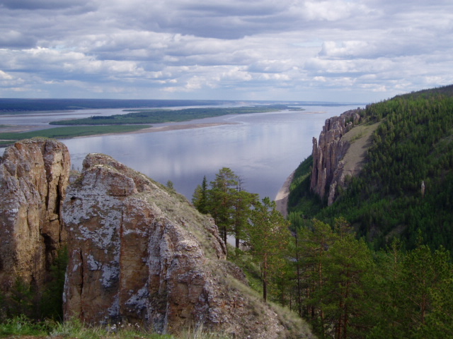 The Lena Pillars along the river near Yakutsk | |
 Lena watershed | |
| Native name | |
| Location | |
| Country | Russia |
| Physical characteristics | |
| Source | Baikal Mountains, Irkutsk Oblast |
| • coordinates | 53°58′3″N 107°52′56″E (approximately) |
| • elevation | 1,640 m (5,380 ft) |
| Mouth | Lena Delta |
• location | Arctic Ocean, Laptev Sea |
• coordinates | 72.4087°N 126.6847°E |
| Length | 4,294 km (2,668 mi) |
| Basin size | 2,460,742 km2 (950,098 sq mi) to 2,490,000 km2 (960,000 sq mi) |
| Width | |
| • maximum | 10,000 m (33,000 ft) |
| Depth | |
| • maximum | 28 m (92 ft) |
| Discharge | |
| • location | Kyusyur, Russia (Basin size: 2,440,000 km2 (940,000 sq mi) to 2,418,974 km2 (933,971 sq mi)[1] |
| • average | (Period of data: 1971-2015)17,773 m3/s (627,600 cu ft/s)[1]
(Period of data: 1970-1999)17,067 m3/s (602,700 cu ft/s)[2] 15,500 m3/s (550,000 cu ft/s)[3] |
| • minimum | 366 m3/s (12,900 cu ft/s) |
| • maximum | 241,000 m3/s (8,500,000 cu ft/s)
Lena Delta, Laptev Sea, Russia (Period of data: 1984-2018)577 km3/a (18,300 m3/s)[1] (Period of data: 1940-2019) 545.7 km3/a (17,290 m3/s)[4] |
| Discharge | |
| • location | Vilyuy |
| • average | 12,100 m3/s (430,000 cu ft/s)
Tabaga, Yakutsk (Basin size: 987,000 km2 (381,000 sq mi) (Period of data: 1967-2017) 7,453.2 m3/s (263,210 cu ft/s)[5](max. 51,600 m3/s (1,820,000 cu ft/s))[5] |
| Discharge | |
| • location | Olyokminsk |
| • average | 4,500 m3/s (160,000 cu ft/s) |
| Discharge | |
| • location | Vitim |
| • average | 1,700 m3/s (60,000 cu ft/s) |
| Discharge | |
| • location | Kirensk |
| • average | 480 m3/s (17,000 cu ft/s) |
| Basin features | |
| Tributaries | |
| • left | Vilyuy |
| • right | Kirenga, Vitim, Olyokma, Aldan |
Course


Originating at an elevation of 1,640 meters (5,381 ft) at its source in the Baikal Mountains south of the Central Siberian Plateau, 7 kilometres (4 mi) west of Lake Baikal, the Lena flows northeast across the Lena-Angara Plateau, being joined by the Kirenga, Vitim and Olyokma. From Yakutsk it enters the Central Yakutian Lowland and flows north until joined by its right-hand tributary the Aldan and its most important left-hand tributary, the Vilyuy. After that, it bends westward and northward, flowing between the Kharaulakh Range, part of the Verkhoyansk Range, in the east and the Chekanovsky Ridge in the west. Making its way nearly due north it expands into a large delta and ends in the Laptev Sea, a division of the Arctic Ocean, south-west of the New Siberian Islands. The Lena Delta is 30,000 square kilometres (12,000 sq mi) in area,[7] being traversed by seven main branches, the most important being the Bykovsky channel, farthest east.
Basin
The area of the Lena river basin is calculated at 2,490,000 square kilometres (960,000 sq mi) and the mean annual discharge is 489 cubic kilometers per year. Gold is washed out of the sands of the Vitim and the Olyokma, and mammoth tusks have been dug out of the delta. There are numerous lakes in the floodplain of the river. Lakes Nedzheli and Ulakhan-Kyuel are the largest in the basin of the Lena.
Tributaries
The Kirenga flows north between the upper Lena River and Lake Baikal. The Vitim drains the area northeast of Lake Baikal. The Olyokma flows north. The Amga makes a long curve southeast and parallel to the Lena and flows into the Aldan. The Aldan also curves roughly parallel to the Lena until it turns east and flows into the Lena north of Yakutsk. The Maya, a tributary of the Aldan, drains an area almost to the Sea of Okhotsk. The T-shaped Chona-Vilyuy system drains most of the area to the west.
The main tributaries of the Lena are, from source to mouth:
- Tutura (right)
- Ilga (left)
- Kuta (left)
- Tayura (right)
- Kirenga (right)
- Pilyuda (left)
- Chechuy (right)
- Ichera (left)
- Chaya (right)
- Chuya (right)
- Vitim (right)
- Peleduy (left)
- Nyuya (left)
- Derba (left)
- Ura (left)
- Bolshoy Patom (right)
- Cherendey (left)
- Biryuk (left)
- Olyokma (right)
- Markha (left)
- Tuolba (right)
- Sinyaya (left)
- Buotama (right)
- Menda (right)
- Myla (right)
- Tamma (right)
- Lyutenge (right)
- Suola (right)
- Aldan (right)
- Batamay (right)
- Belyanka (right)
- Lyapiske (right)
- Tympylykan (left)
- Dyanyshka (right)
- Tyugyuene (left)
- Sitte (left)
- Khanchaly (left)
- Kenkeme (left)
- Lungkha (left)
- Namana (left)
- Vilyuy (left)
- Linde (left)
- Undyulyung (right)
- Nuora (left)
- Begidyan (right)
- Khoruongka (left)
- Sobolokh-Mayan (right)
- Muna (left)
- Menkere (right)
- Motorchuna (left)
- Molodo (left)
- Natara (right)
- Uel-Siktyakh (right)
- Kuranakh-Siktyakh (right)
- Eyekit (left)
- Bulkur (left)
History
Lena River from a source to Kachug | ||||||||||||||||||||||||||||||||||||||||||||||||||||||||||||||||||||||||||||||||||||||||||||||||||||||||||||||||||||||||||||||||||||||||||||||||||||||||||||||||||||||||
|---|---|---|---|---|---|---|---|---|---|---|---|---|---|---|---|---|---|---|---|---|---|---|---|---|---|---|---|---|---|---|---|---|---|---|---|---|---|---|---|---|---|---|---|---|---|---|---|---|---|---|---|---|---|---|---|---|---|---|---|---|---|---|---|---|---|---|---|---|---|---|---|---|---|---|---|---|---|---|---|---|---|---|---|---|---|---|---|---|---|---|---|---|---|---|---|---|---|---|---|---|---|---|---|---|---|---|---|---|---|---|---|---|---|---|---|---|---|---|---|---|---|---|---|---|---|---|---|---|---|---|---|---|---|---|---|---|---|---|---|---|---|---|---|---|---|---|---|---|---|---|---|---|---|---|---|---|---|---|---|---|---|---|---|---|---|---|---|---|
| ||||||||||||||||||||||||||||||||||||||||||||||||||||||||||||||||||||||||||||||||||||||||||||||||||||||||||||||||||||||||||||||||||||||||||||||||||||||||||||||||||||||||
It is commonly believed that the Lena derives its name from the original Even-Evenk name Elyu-Ene, which means "the Large River".
According to folktales related a century later, in the years 1620–1623 a party of Russian fur hunters under the leadership of Demid Pyanda sailed up Nizhnyaya Tunguska, discovered the Lena, and either carried their boats there or built new ones. In 1623 Pyanda explored some 2,400 kilometres (1,500 mi) of the river from its upper reaches to the central Yakutia.[8] In 1628 Vasily Bugor and 10 men reached the Lena, collected 'yasak' (tribute) from the 'natives' and then founded Kirinsk in 1632. In 1631 the voyevoda of Yeniseysk sent Pyotr Beketov and 20 men to construct a fortress at Yakutsk (founded in 1632). From Yakutsk other expeditions spread out to the south and east. The Lena delta was reached in 1633.
Two of the three group of survivors of ill-fated Jeannette expedition reached Lena Delta in September 1881. The one led by engineer George W. Melville was rescued by native Tungus huntsmen. Of the group led by Captain George W. De Long only two of the men survived, the others died of starvation.
Baron Eduard Von Toll, accompanied by Alexander von Bunge, led an expedition that explored the Lena delta and the islands of New Siberia on behalf of the Russian Imperial Academy of Sciences in 1885. In 1886 they investigated the New Siberian Islands and the Yana River and its tributaries. During one year and two days the expedition covered 25,000 kilometres (16,000 mi), of which 4,200 kilometres (2,600 mi) were up rivers, carrying out geodesic surveys en route.
The Lena massacre was the name given to the 1912 shooting-down of striking goldminers and local citizens who protested at the working conditions in the mine near Bodaybo in northern Irkutsk. The incident was reported in the Duma (parliament) by Kerensky and is credited with stimulating revolutionary feeling in Russia.
Vladimir Ilyich Ulyanov may have taken his alias, Lenin, from the river Lena, when he was exiled to the Central Siberian Plateau.
Delta


At the end of the Lena River there is a large delta that extends 100 kilometres (62 mi) into the Laptev Sea and is about 400 km (250 mi) wide. The delta is frozen tundra for about seven months of the year, but in May the region is transformed into a lush wetland for a few months. Part of the area is protected as the Lena Delta Wildlife Reserve.
The Lena delta divides into a multitude of flat islands. The most important are (from west to east): Chychas Aryta, Petrushka, Sagastyr, Samakh Ary Diyete, Turkan Bel'keydere, Sasyllakh Ary, Kolkhoztakh Bel'keydere, Grigoriy Diyelyakh Bel'kee (Grigoriy Islands), Nerpa Uolun Aryta, Misha Bel'keydere, Atakhtay Bel'kedere, Arangastakh, Urdiuk Pastakh Bel'key, Agys Past' Aryta, Dallalakh Island, Otto Ary, Ullakhan Ary and Orto Ues Aryta.
Turukannakh-Kumaga is a long and narrow island off the Lena delta's western shore.
One of the Lena delta islands, Ostrov Amerika-Kuba-Aryta or Ostrov Kuba-Aryta, was named after the island of Cuba during Soviet times. It is on the northern edge of the delta.[9]

Further reading
- Alexander von Bunge & Eduard von Toll (1887), The Expedition to the New Siberian Islands and the Yana country, equipped by the Imperial Academy of Sciences.
- Jeffrey Tayler (2006), River of No Reprieve: Descending Siberia's Waterway of Exile, Death, and Destiny
See also
- Lena Cheeks
- Lena Pillars
- Lena Plateau
- List of rivers of Russia
- List of longest undammed rivers
- Tukulan
- William Barr, writer of The First Soviet Convoy to the Mouth of the Lena.
 Siberia portal
References
- Stadnyk, Tricia A.; Tefs, A.; Broesky, M.; Déry, S. J.; Myers, P. G.; Ridenour, N. A.; Koenig, K.; Vonderbank, L.; Gustafsson, D. (2021). "Changing freshwater contributions to the Arctic". Elementa: Science of the Anthropocene. 9. doi:10.1525/elementa.2020.00098. S2CID 236682638.
- "Variations of the Present-Day Annual and Seasonal Runoff in the Far East and Siberia with the Use of Regional Hydrological and Global Climate Models" (PDF). 2018.
- http://www.abratsev.narod.ru/biblio/sokolov/p1ch23b.html, Sokolov, Eastern Siberia // Hydrography of USSR. (in russian)
- "River Discharge".
- "HAL". 2021.
- "Река Лена in the State Water Register of Russia". textual.ru (in Russian).
- "Lena River Delta - A Global Ecoregion". World Wide Fund for Nature. 2006-07-06. Archived from the original on 2007-06-30. Retrieved 2008-05-23.
- "Открытие русскими Средней и Восточной Сибири". www.randewy.ru. Retrieved 4 April 2018.
- "Google Maps". Google Maps. Retrieved 4 April 2018.
- This article incorporates text from a publication now in the public domain: Chisholm, Hugh, ed. (1911). "Lena". Encyclopædia Britannica. Vol. 16 (11th ed.). Cambridge University Press.
External links
 Media related to Lena River at Wikimedia Commons
- Arctic Great Rivers Observatory (ArcticGRO)
- NASA Earth Observatory page on flooding on the Lena River
- Information and a map of the Lena's watershed
- Permafrost in the Lena Delta
- Alfred Wegner institute (AWI) Publications, Berichte zur Polar- und Meeresforschung (Reports on polar and marine research) - free, downloadable research reports on the biology, geology, oceanography, hydrology, paleontology, paleoclimatology, fauna, flora, soils, cryology, and so forth of the Lena Delta, Laptev Sea, and other parts of the Arctic Circle.
|
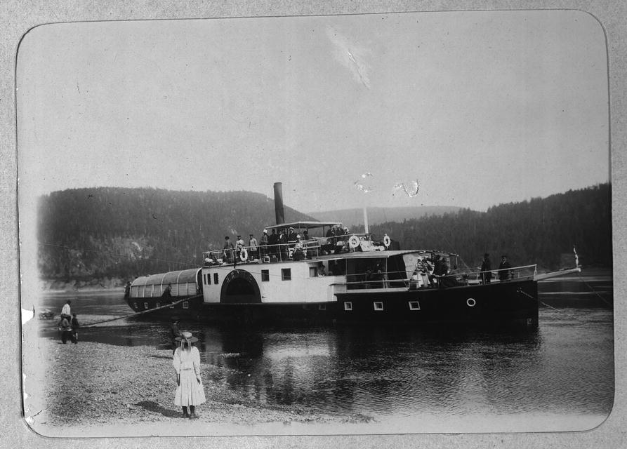
Shipbuilding and shipping on the river Lena | |||||||
|---|---|---|---|---|---|---|---|
| Shipbuilding |
| ||||||
| River ports |
| ||||||
| Ship types |
| ||||||
| Well-known vessels |
| ||||||
| Well-known travels |
| ||||||
| River accidents |
| ||||||
| Significant persons |
| ||||||
Earth's primary regions and subregions | |||||||||||||||||||||||||||||||||||||||||||||||||||||
|---|---|---|---|---|---|---|---|---|---|---|---|---|---|---|---|---|---|---|---|---|---|---|---|---|---|---|---|---|---|---|---|---|---|---|---|---|---|---|---|---|---|---|---|---|---|---|---|---|---|---|---|---|---|
| |||||||||||||||||||||||||||||||||||||||||||||||||||||
Authority control | |
|---|---|
| General |
|
| National libraries | |
| Other |
|
На других языках
[de] Lena (Arktischer Ozean)
Die Lena (russisch Лена; jakutisch Өлүөнэ, Ölüöne) ist ein Strom in Sibirien im asiatischen Teil Russlands. Sie mündet in die Laptewsee, ein Randmeer des Arktischen Ozeans. Die Lena ist von der Quelle bis zum Lenadelta 4294 km lang, über den wasserreichsten Deltaarm Bykowsskaja Protoka[1][6] sind es sogar insgesamt 4400 km. Sie gehört zu den längsten Flüssen der Erde.- [en] Lena (river)
[it] Lena (fiume)
La Lena (in russo Ле́на; in sacha Ulachan Örüs, grande fiume)[1][2] è il più orientale dei tre grandi fiumi artici siberiani (gli altri due sono l'Ob' e l'Enisej) che fluiscono nel Mar Glaciale Artico. Attraversa la Siberia orientale da sud a nord per sfociare nel mare di Laptev dopo un percorso di oltre 4.400 km,[1] drenando un bacino di 2.490.000 km².[2] La Lena è il decimo fiume più lungo del mondo[2] e fra i maggiori per ampiezza di bacino, il quale coincide, sostanzialmente, con l'intera Siberia orientale.[ru] Лена
Ле́на[4] (якут. Улахан Өрүс[5] — «большая река»[6], якут. Өлүөнэ (Öлÿöнä)[7], бур. Зүлхэ, эвенк. Елюенэ[8]) — река в Восточной Сибири России[9], впадает в море Лаптевых Северного Ледовитого океана. Длина вместе с дельтой — 4400[6] км. В некоторых случаях указывается длина 4294 км[10] без учёта Быковской протоки (106 км) в дельте Лены. Площадь бассейна — 2,49 млн км²[10]. Годовой сток равен 515,6 км³.Другой контент может иметь иную лицензию. Перед использованием материалов сайта WikiSort.org внимательно изучите правила лицензирования конкретных элементов наполнения сайта.
WikiSort.org - проект по пересортировке и дополнению контента Википедии