geo.wikisort.org - Island
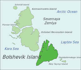
Bolshevik Island (Russian: о́стров Большеви́к, pronounced [ˈostrəf bəlʲʂɨˈvʲik]) is an island in Severnaya Zemlya, Krasnoyarsk Krai, Russian Arctic. The island is named after the political faction of the same name.
Native name: о́стров Большеви́к | |
|---|---|
 Bolshevik Island, Russia | |
 Bolshevik Island Bolshevik Island in Krasnoyarsk Krai, Russia | |
| Geography | |
| Location | Arctic |
| Coordinates | 78.630006°N 102.480469°E |
| Archipelago | Severnaya Zemlya |
| Area | 11,270 km2 (4,350 sq mi)[1] |
| Area rank | 66th[1] |
| Highest elevation | 935 m (3068 ft) |
| Highest point | unnamed |
| Administration | |
Russia | |
| Demographics | |
| Population | 0 |
History
The island, together with the eastern coast of what was named Emperor Nicholas II Land, was discovered by Boris Vilkitsky at the time of the 1913 Arctic Ocean Hydrographic Expedition. Its insularity, however, wasn't proven until 1931, when Georgy Ushakov and Nikolay Urvantsev charted the archipelago during their 1930–32 expedition.[2]
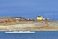
Prima Polar Station,[3] currently the only Polar station operating in Severnaya Zemlya, is located in this island near Cape Baranov.[4]
Geography
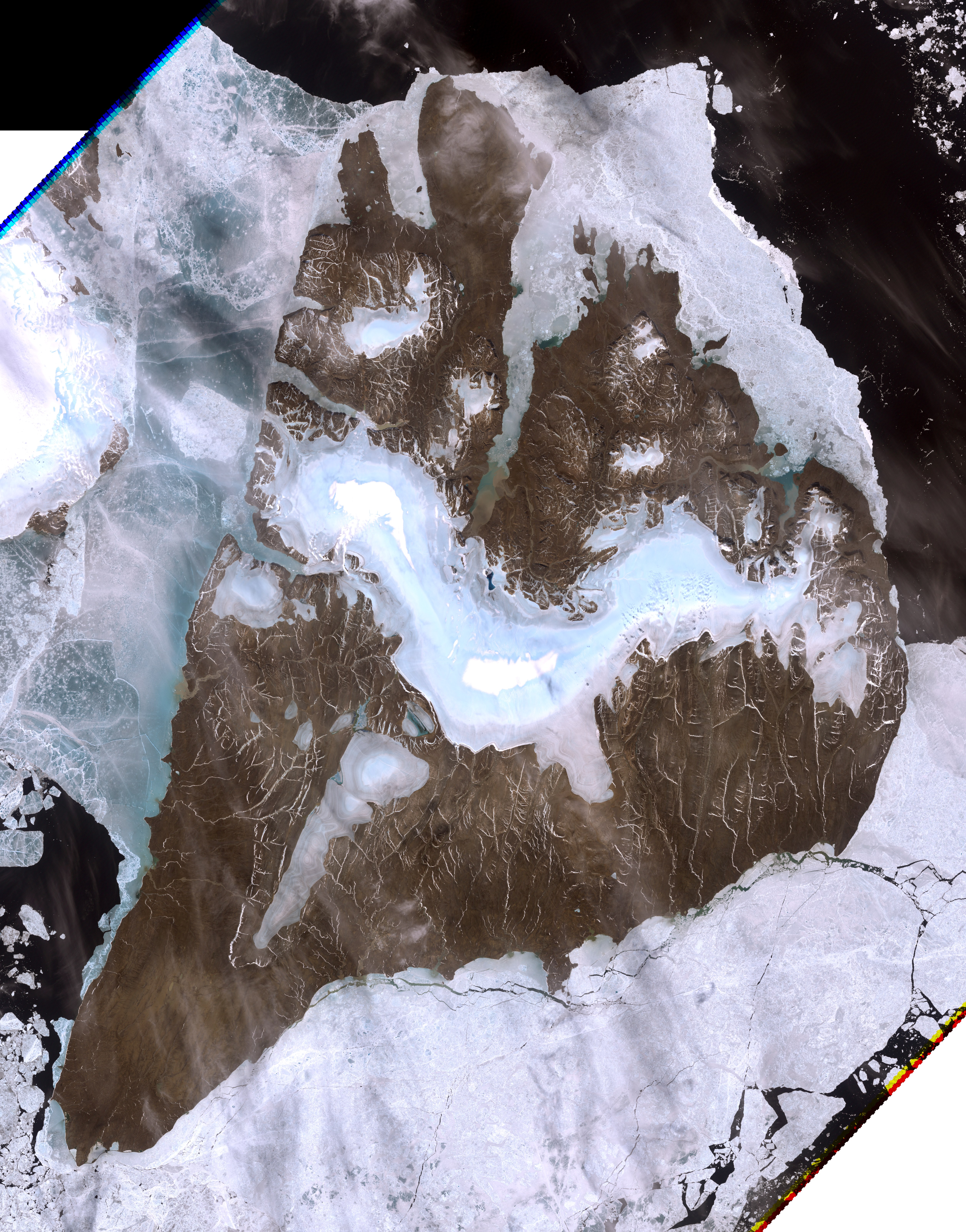
It is the southernmost island and the second largest island in the group. The area of this island has been estimated at 11,270 km2 (4,350 sq mi).[1] The island is mountainous reaching a height of 935 m. About 31% of Bolshevik Island, totaling over 3,300 km2 (1,300 sq mi), is covered by glaciers, the largest are Leningrad Glacier, Semyonov-Tyan-Shansky Glacier, Kropotkin Glacier, Mushketov Glacier and Aerosyomki Glacier. Most of these ice formations do not reach the sea, ending in moraines in valleys or coastal plains having a sparse vegetation of moss and lichen.[5]
Parts of the shore of the island are deeply indented, with Mikoyan Bay in the northopening to the Shokalsky Strait, as well as fjords such as Akhmatov Fjord, Thaelmann Fjord, Spartak Fjord and Partizan Fjord. Cape Unslicht (Mys Peschanyy) is the northernmost point of Bolshevik Island[6] and Cape Neupokoyev at the SW end the southernmost.[7] Ostrov Tash is a small island located on Bolshevik's southern shore. Lavrov Island and Blizky Island are located off the NE shore and Ostrov Lishniy off its northern tip.
The group formed by the larger Maly Taymyr and Starokadomsky islands is located further offshore off the southeastern end.
Image gallery
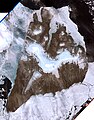 Bolshevik Island image (Landsat-7 1999-07-29)
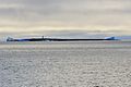 Southern coast of
Bolshevik Island:
Antsev Point (78°11’N, 103°7’E)

 Bolshevik Island:
Akhmatov Fjord (79°30‘N, 103°12‘E)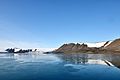 Bolshevik Island:
Akhmatov Fjord (79°30‘N, 103°12‘E) Bolshevik Island:
Mikoyan Bay at one of the world's most spectacular iceberg roads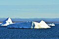 Bolshevik Island:
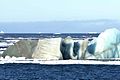
Mikoyan Bay (79°22‘N, 102°E) Northeast coast of Bolshevik Island:
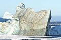
iceberg road (79°28‘N, 103°E)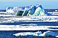 Northeast coast of Bolshevik Island:
iceberg road (79°28‘N, 103°E)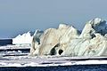


Weather conditions
The weather on the island is extremely cold; the annual average temperature is −16 °C (3 °F).[5]
See also
- List of islands of Russia
- List of research stations in the Arctic
References
- McCoy, John F. (ed.) (2002) Geo-Data: The World Geographical Encyclopedia Thomson-Gale
- Barr, William (1975). "Severnaya Zemlya: the last major discovery". Geographical Journal. 141 (1): 59–71. JSTOR 1796946.
- Фотогалерея: 2004 - "Полярное Кольцо" - Местонахождение: 17 мая, Северная Земля, о.Большевик, м.Баранова, п/ст Примах
- Bird Observations in Severnaya Zemlya, Siberia
- ""Severnaya Zemlya"". Archived from the original on 2010-12-23. Retrieved 2009-03-14.
{{cite web}}: CS1 maint: bot: original URL status unknown (link) (translated as "North Land). Oceandots.com. Accessed May 2011 - "Mys Peschanyy". Mapcarta. Retrieved 27 November 2016.
- "Mys Neupokoyeva". Mapcarta. Retrieved 29 November 2016.
External links
 Media related to Bolshevik Island at Wikimedia Commons
|
На других языках
[de] Bolschewik-Insel
Die Bolschewik-Insel (russisch о́стров Большеви́к, Ostrow Bolschewik) ist eine im Arktischen Ozean nördlich des russischen Festlands gelegene Insel. Sie ist die südlichste und mit etwa 11.312 km² nach der Insel der Oktoberrevolution die zweitgrößte Insel im Sewernaja-Semlja-Archipel.- [en] Bolshevik Island
[es] Isla Bolchevique
La isla Bolchevique (en ruso, Остров Большевик) es una isla de Rusia localizada en el Ártico, la más meridional de las islas del grupo de Severnaya Zemlya. Con una superficie estimada de 11.031 km², es la segunda isla más grande del grupo y la 70ª isla más grande del mundo. La isla está situada entre el mar de Kara y el mar de Láptev.[fr] Île Bolchevique
L’île Bolchevique (en russe : о́стров Большеви́к) est une île de l'archipel de la Terre du Nord, en Russie, entre la mer de Kara et la mer des Laptev. Elle est la deuxième île de l'archipel par sa taille et également son île la plus méridionale. Elle est séparée du continent par le détroit de Vilkitski et de l'île de la Révolution d'Octobre par le détroit de Chokalski.[it] Isola Bolscevica
L'isola Bolscevica (in russo: остров Большевик?, traslitterato: ostrov Bol'ševik), è l'isola più a sud dell'arcipelago delle Severnaja Zemlja, nella sezione russa dell'oceano Artico, tra il mare di Laptev e il mare di Kara, costituendo la seconda maggiore isola nel gruppo, dopo l'isola della Rivoluzione d'Ottobre, che si trova poco più a nord, separata dallo stretto di Šokal'skij. Politicamente, fa parte del Territorio di Krasnojarsk, in Russia.[ru] Большевик (остров)
Большеви́к — второй по величине остров архипелага Северная Земля и его южная оконечность. Отделён от материка проливом Вилькицкого, а от острова Октябрьской Революции — проливом Шокальского. Омывается Карским морем и морем Лаптевых.Другой контент может иметь иную лицензию. Перед использованием материалов сайта WikiSort.org внимательно изучите правила лицензирования конкретных элементов наполнения сайта.
WikiSort.org - проект по пересортировке и дополнению контента Википедии